A typical one day trip for me....600 miles, 60 pictures and
17.5 hours on the road....
Sheesh, when will I learn !!!
Grab a coffee or put the kettle on for
a cup of tea cause this is going to be a long one...
My usual shotgun partner Ron Patrick and myself set a daunting agenda for the day, but we did it, and we're not tired.. or proud... (apologies to Arlo Guthrie of "Alice's Restaurant" fame)
Time stamp: 5.20 am
Meow.....meow........ meow.......meow......meow
where's my shoe when I need it..
Get up to feed the cat, then get up 10 minutes later to let the cat out, then get up again 10 minutes later to let said cat in.. oh well, guess I'm up now.....
Picked up Ron Patrick around 7.00 am and we highballed it from Maple Ridge to the Fraser Canyon for our first highlight stop of the day, the town of Lytton.
Lytton is considered the northern end of the wild Fraser Canyon.
It has also had First Nations people living at the confluence of the Fraser and Thompson rivers for over 9,000 years.
Lytton is usually the hotspot of Canada due to the sheltering nature of the Coast Mountain range. Most of the rain falls on the westward side, so Lytton on the inland side receives only warm dry winds to buffet the canyon. Lodgepole pine and sage grass are typical of the flora in the area. An amazing sight is the two train bridges over the Fraser just south of Lytton. Here Canadian Pacific and Canadian Rail exchange sides of the river before they plunge into the heart of the Canyon on their southward journey.
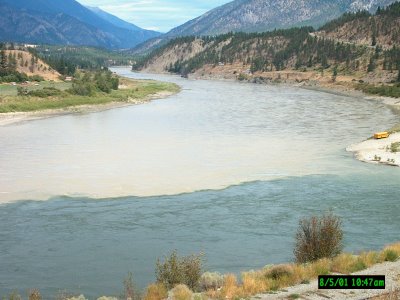
Another sight to see is the joining of the water of two rivers.
The Thompson runs through mostly hard rock or gravel hills and mountains on it's journey, picking up "cleaner" detriment while the Fraser eats away at the softer sandstone and clay on it's route, turning the river silt brown.
The blue, clean waters of the Thompson merge with the brown muddy water of the Fraser, and the stark contrast between the two is something to see.
Lytton was also one of the important forks along the Gold Rush Trail.
If you followed the Fraser you headed towards the northern gold fields around Quesnel and Barkerville, and, if you followed the Thompson you headed easterly for the silver and copper mines in the Interior.


Staying on Hwy#1 you follow the Thompson river and are immediately plunged into the Thompson Canyon. While smaller in scale than the Fraser Canyon, it is no less impressive.
Here the river runs through an arid land, even less trees to be seen than before due to lack of good soil. This route travels along the western edge of the Thompson plateau which extends northward for several hundred miles, east for 200 miles, and south for 100 miles.
Most of the plateau was covered in successive glaciers, the latest retreated only 10,000 years ago. As a result, much of the land formations are a direct result of their actions. In this case, most of the area in the Thompson's watershed is comprised of high mountains made of hard bedrock, with the wide valley's between filled with low rolling hills consisting of mostly gravel which was deposited as the glaciers retreated in a northerly direction. Hence, some of the pictures you view will show large areas of unstable river banks, especially evident in the canyon shots.

Our next stop was Ashcroft, specifically Ashcroft Manor, which is now a museum.
This is one of the view remaining road houses from the Gold Rush route to the Cariboo, used at first by miners walking the route, then later as a stage coach overnight stop as they traveled between the coast and inland.
The Manor is truly an oasis among the desert. After traveling for 100 miles or so through an arid land with few trees and only sage grass for ground cover, the bright greens of the grass at the manor have a cooling effect on the body. We poked around the museum's grounds checking out the antiquated kitchen and the main floor. On the walls of the hallways they had old pictures from the late 1800's of the Manor, as well as a few old rifles such as Enfields and Winchesters.
Out back they had several original buildings still in original shape. One of these was a 3 room sod hut that served as a storage shed and a living quarters. The rooms on either end of the building housed the Chinese who worked on the property, while the middle room was a storage shed for food stores that they kept cool by diverting a creek to run through the cabin.
From Ashcroft we turned southeast and climbed steeply as we
gained the altitude of the Highland Plateau. Here the climate was cooler, and we began to see more spruce and fir, as well as the white bark of Aspen trees. We traversed the plateau for 20-30 miles, then began a descent into the ancient crater of a volcano many miles wide. It is here the Highland mines has one of it's 4 open pit mines.
Coming around a corner of the road we were suddenly treated to a rare treat amongst the drab dark greens of the forest.

Emerald greens and bright white lept of the landscape into our vision.
After a minute of disbelief, we realized that the lake that we saw was an enormous tailing pond for one of the open pit mines in the area.
The pond stretches for 7 miles east to west, with earthen dams at either end. While it was only a "sewage" pond, the scene was amazing nonetheless.
At the eastern end of the pond is the beginning of one of the mines.
This one stretched for 4 miles east to west, and 3 miles north to south.
It filled the entire landscape before us, or I should say, it ate up the entire valley before us.
Molybdenum and low grade ore are hauled from the mine face in large mine trucks, some of which we could see off in the distance hauling waste ore to the dumps sites.
Even from our vantage point a mile or so away they looked huge.
Their true size was evident when one of them passed a school bus used to shuttle employees within the mine. The bus looked like a Tonka toy in front of a real car.
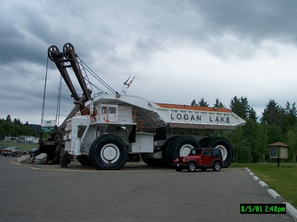
Another 10 miles brought us to the instant town of Logan Lake.
Most of the mining company's employees live in Merritt, approx 50 miles away. The company wanted to have the people live closer to the mine, so in 1970 they created the town of Logan Lake. One of the more unique tourist bureau's I have ever seen is located here. The mine donated an old mine truck and an old tractor-shovel used for loading the massive trucks.
Inside the main body of the shovel is the tourist centre...pretty cool!
After a quick look around town, we once again did a pinball move on the map.
Instead of continuing south east to Merritt, we instead headed due north along 45 miles of gravel road for a meeting with the Trans-Canada Hwy at a point west of Kamloops. Halfway into the route we passed Tunkwa Lake. This is a newly created park with 3 large open area campgrounds at the north end of the lake. Very picturesque, worth a visit if you get up that way. The main activities are fishing and walks along the open grass areas around the lake. Yes, the biozone had changed again, and as we headed north we lost elevation, the air warmed up, and we entered the transition zone from cool mountain with large trees to open rolling grassland with lodgepole pines dominating the landscape. We noticed unusually large samples of bunchgrass, some six feet high. These were so strong they were pushing the farm fences out of their way as they grew.
We finished our descent and arrived at the small community of Savona.
Reunited with Hwy#1, we headed 60 miles east to Kamloops.
As we were pulling into town we realized that it was nearing dinner time, meaning we had already been on the road for 10 hours. I phoned home to let Annette know where we were, and she just laughed and asked if we were spending the night! I said "No, we'd be home tonight", maybe very late, but we'd be home......
Kamloops is one of the larger towns in the Interior of BC, and, as usual, every time I come through here there are more and more houses, condos, strip malls and traffic. We gassed up in town, but what we really wanted was the east side of town and the road signs pointing us in the direction of Monte Lake. The route we were now on was once one of the original Hudson Bay Fur Brigade trails, and along these trails the famous brigades were a sight to behold. 400 horses handled by 40 men stretched out for miles, a sight that the local Indians always found curious.
The route originated in Merritt, went to Nicola Lake, east to the Douglas Plateau past Douglas Lake, then north to Westwold were it forked, one path west to Monte Lake, the other east towards Salmon Arm. We were following the Brigade Trail in a reverse direction, starting from Westwold and heading south into Cowboy Country......
This was also the northern terminus of the Douglas Lake Road, one of my main objectives for the day.
We turned south and entered the narrow canyon through which the Salmon River flowed. Once again we were in the cool air, only this time we had not climbed 2000 feet.
Ron and I were surprised when we noticed that the canyon looked like any other in the P.N.W.
This was a different venue for us, as all day we had either been traveling through a barren, arid landscape, or driving through alpine areas with small evergreens that were sparsely spaced.
The small river traveled quietly as it threaded it's way along the valley floor amid the ferns and firs that lined the route.
Just when we thought we were a long way from civilization, we would turn a corner and come across a small farm nestled in the turn of the river. Each one of these idyllic settings caused us to murmur that we would like to live here, but we were both sure that we would be all by ourselves if we did.
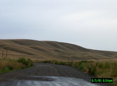
25 miles driving gave us another transition zone. The canyon walls slowly faded away, and see forever rolling hills of prairie grass were before us.
We could see the higher, "real" mountains miles off in the distance, but all around us was prime grazing land.
We could just imagine all the cattle that must be grazing just over the crest of every hill we saw.
Here high on the Douglas Plateau was ample evidence of glacial action.
The creation of the plateau itself was caused by the massive ice sheets that covered most of B.C., the latest ice age occurring just 10,000 years ago. The mountains were ground down, the plateaus ripped open and reformed, leaving wide open valleys filled with rolling hills. In between ice ages the area was covered three different times by huge ice melt lakes that stretched from Spences Bridge and Ashcroft in the west, to Merritt in the south and Kamloops in the north. The ancient shoreline of these lakes are still visible high on the surrounding mountains, particularly so when accented by the first snow of the season.
The many north-south lying chain of lakes indicate the direction of the ice movement. Drumlins and eskers, side and front moraines, and erratics such as huge boulders in the open fields, mark were the ice melted, dropping it's heavy load.
 Finally, after miles and miles of grassland, we turned a corner and there below us, nestled against the north shore of Douglas Lake was the ranch. It is the largest working ranch in Canada, consisting of 500,000 acres. It had it's beginnings during the days of construction of the Trans-Canada railways.
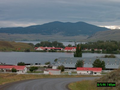
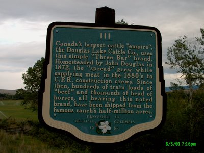
It supplied most of the beef and a lot of the farm food for the hungry crews in Western Canada. As was common, with the ranch being so large and so far from the nearest town, the ranch took on all the functions of a small town, complete with general store and it's own post office, even it's own church. Hundreds of thousands of cattle and horses have passed through the ranch over the years. For a long time it was owned by the Woodwards family, which owned the now defunct Woowards department stores. Guests such as Tom Jones and Queen Elizabeth have been entertained in the luxurious ranch house, and ridden the open range with the cowboys on the ranch.

At the small Indian village of Spahomin, (meaning little reeds, which are woven to form fish nets), we once again changed direction and headed for the eastern shore of Nicola Lake. Just north of the Quilchena Hotel, (been there, done that) we arrived back on blacktop at the junction of the Douglas Lake Road and Hwy 97C. This was the official "end" of our day's drive, however we still had a 3 hour drive back to theVancouver area and home.

We stopped off in Merritt for a break, filled up the tummies and drinking mugs, gassed up the Jeep and made some re-assuring phone calls to home to let them know we were still in one piece.
It was now 9.30pm, which put our arrival time home after midnight.
17.5 hours on the road was a bit much, but we wanted to cover some new territory and not have to backtrack in doing so.
WELL, WE MADE IT!!
And did you go through a whole pot of coffee or tea reading this road trip?
No comments:
Post a Comment