Sunday, December 10, 2006

A Muddy Cache Indeed !!


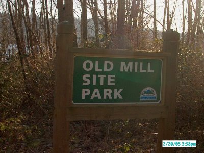
Annacis Island is located in the South Arm of the Fraser River. On the island there is a cache located at its most westerly tip; the cache is called “What’s the Point?” and it is hidden by Gorak.

The cache is located approx 1/3 of a mile from parking, but it’s the last 1000 feet that you have to be prepared for.

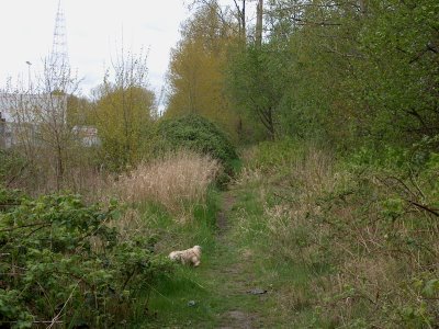
The walk starts off pleasant enough as you walk along an overgrown trail along the top of the dike. After approximately 200 feet the trail takes a slight bend as it moves away from the dike and now runs along an old skid road through the bush.

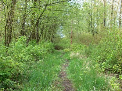
Again, so far so good; this part of the trail is a good gravel “road” easy to walk on.
Along this part is another cache called “Used Cassette Exchange” hidden originally by Team Muppet, now adopted by Queens Borrowers. Their cache is located next to the trail and is easily accessible.

Continuing on, the trail takes another bend and suddenly comes to a dead end.
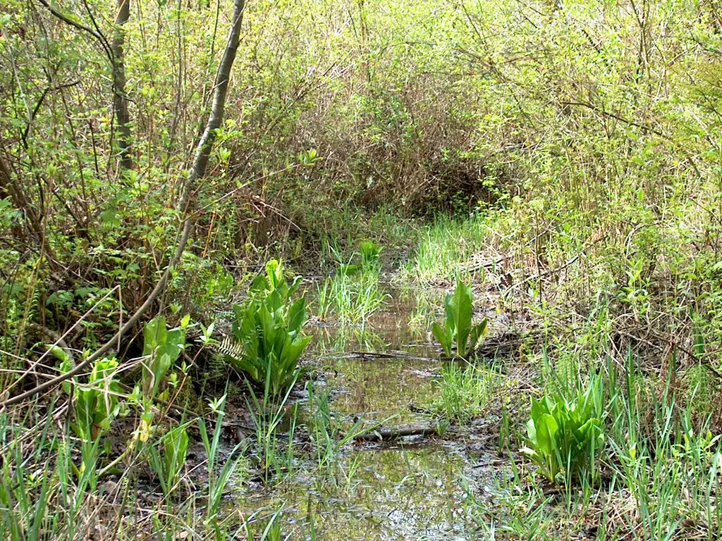
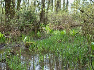
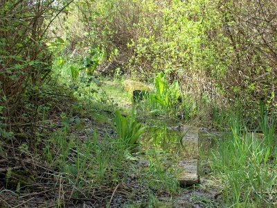
Well, at least you think it does: the trail carries on along the skid road but the road level is lower than before. Consequently rain water sits through here and the road is being reclaimed by nature in the form of a swamp.

Skunk cabbage grows large through this area and deep, slippery mud puddles force you to put on your big rubber boots to keep your feet dry. Hidden boards lying in the muck below the stagnant water are hoping you will step on them and take a slip-slide tumble onto your keyster, causing sure calamity for you and a definite photo-op for you companions.

Once you get through the swamp the real fun begins: you have to cross the moat!
The moat is actually a side channel of water that cuts through the island. At best it is a 'boot sucking' mud crossing that threatens to suck your boots right off your feet leaving you hopping in the mud on one foot! And you know that never works….

At worst the moat is filled with 4 feet of water as the tide in the Fraser River rises and floods this end of the island. Across the moat some one has strung a large log chained at either end to large poles stuck in the ground. I don’t know about you, but log rolling was never my best subject in high school. It would be pretty tough to make it across the log without taking a bath.

We had timed our arrival at this cache to coincide with the lowest tide of the day:
HEY, we’re smart fellers. “I am so smart, S-M-R-T!”
Today we only had to risk having our boots sucked from our feet as we walked bravely across the channel with our gum boots making “shtuck shtuck” sounds as we took each stride.

Once past the moat the island appeared to be all tall grass, how ever that’s too good to be true. The tall grass hides more ankle deep mud that makes your boots go “shtick shtick” with each stride. Not quite as bad as the moat but definitely 'no running' through here.
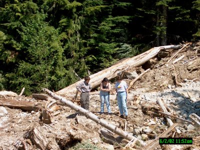
Once past the grass you reach the end of the island and you are now walking on the break water consisting of large boulders. The cache is an easy find at this point and almost anticlimactic. The real challenge was just walking the last 1000 feet!

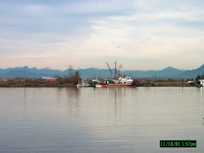
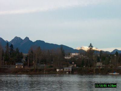
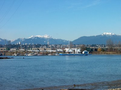
The view from here is beautiful as you are surrounded on both sides by the Fraser River with the marine traffic chugging by just a stone’s throw away. To the south is Delta with industry all along River Road and at the river’s edge; to the north is Richmond and large box warehouses along the river front. Way off to the north the North Shore Mountains in North Vancouver stand as testament to the forest that lays just beyond the city.

We took our time here as we signed the log book and sat on the rocks taking in the vista from this rare vantage point. Eventually we gathered up our gear and began the trek back through the 'shtick shtick' mud, through the 'shtuck shtuck' mud in the moat, and back along the swampy trail past the smelly skunk cabbage.

I’m told by other cachers that along the north shore of the island there is an old board walk along the water’s edge, reminiscent of by gone days when squatters may have lived there.

Back on dry land our boots were testament how muddy the walk to the cache had been, and how happy we were we had planned the visit to the cache just right.
As we walked back to the car we felt like fisherman just stepping off the river after a day of fresh water fly fishing. Our choice of foot gear was gangly and awkward on dry land, but necessary where we just came from.

This was a rewarding cache to find as the journey required foresight and the cache area was a treat to visit.

A Day in the Life of a Geocacher


I first wrote this story for a Backroads group I belong to as a way of explaining what geocaching is all about. The story has appeared in Icenrye's geocaching videozine episode 13. You can catch all of Icenrye's videozines at www.Icenrye.com, on YouTube and on PodcastAlley.

For Christmas my loving wife gave me one of my "toys" that was on my long wish list: a Magellan Gold GPS. I wanted it mostly for back roading and off-roading, as here in B.C. the Forest Service Roads are poorly marked.

After a bunch of twists and turns, with several forks in the road, and darkness descending, all of the FSRs begin to look the same. A GPS ensures that you get home safe.

While I was getting familiar with my GPS, I remembered talking to some other group members on the Mineral Lake tour in Washington. At Mineral lake these folks took out there GPS and searched for a geo-cache. This is a stash of treasure; usually trinkets, that people have hidden in their home areas, and then post the co-ordinates to one of the "community" sites like Geocaching.com.

I logged on to the web site, created an account for myself, (TJGUY98), and then searched for some caches near my house. With 215,524 caches in 218 countries, it wasn't hard to find several within a couple of miles of my house. With GPS in hand I raced down to find the cache, and failed. Not because the cache wasn't there, but more from my lack of knowledge on how to use the GPS.

Well, a couple of months later, and some experience under my belt, I've become much more adept at using the GPS; I've explored it's various navigation screens and menu options, as well as discovered how to create waypoints and use the GO TO features employed in tracking your way to a known set of coordinates.

Keeping all this in mind, you'll understand my story a little better.

On this day my brother Ken and I decided to go geocaching for the whole day. We picked an area where we could find roughly a dozen caches, knowing that we would only make it to some of them. With the driving between sites and the leisurely walks to the cache site itself, you'd be surprised how much time gets eaten up in a day.

Today we headed for two areas: our first destination was the Mission area of the Fraser Valley about 50 miles east of Vancouver BC. The second area was right across on the Fraser River on the Fraser’s south shore, this second area is the northern section of Abbotsford.

Once we began our journey, one of the first things we observed near Mission was a Cormorant on a local pond juggling a fish in its mouth; the bird flipped the fish several times in its mouth as it manoeuvred the fish to swallow it. Now that was neat to see!

Our first stop was at a cache called Complex Mission Sports,(for those cachers in the group it's waypoint name is GCHD99). This one was located in a small forest area on the edge of a large outdoor sports complex. At the complex are several baseball diamonds, as well as several soccer fields. Two of the soccer fields were in use by young girls teams playing hard in the sunny, but cool morning air.

While we were searching for the cache, Ken's dog decided to roll in some unknown substance on the forest floor: that's never a good sign! We found the cache with minimum fuss and had a look through the odds and ends in the cache; I took two "home made" music CD's created by one of the local family caching teams. These folks have made over 50 music CD's, complete with an announcer between songs sending "hellos" out to other local cachers...sounds a lot like Underground radio.

It must take a lot of time and effort to simulate a radio station, and it shows a lot of dedication to their fellow members, good on them! I left a Maytag Olfa knife, and Chirpy the Travel Bug. Travel Bugs are serialized dog tags that people buy and then attach some cute item, like a dinosaur, or toy soldier, or in this case, a largish plush toy spider. These travel bugs are logged on a separate area within Geocaching.com, and you can follow them as they make their way around the country, or around the world. It all depends on where their owner wants them to go.

I had picked up Chirpy the weekend before in Port Moody at another cache, and the instructions for Chirpy stated that she wanted to go to the mountains for the summer. So I took her for a 50 mile drive and dropped her off at this cache for the next person to pick up and carry her on her journey.

We signed the small logbook in the cache, and moved on to the next cache. Our next stop was only a few miles away on the hillside above the town of Mission; this one was called College Cache, (CJV2B). It was called this as it is only a few blocks away from the local college. The actual cache was located along a neat little linear park that was sandwiched between subdivisions. You walk along an elevated boardwalk as you gain elevation to go from one subdivision to the next. The park contains a small creek that flows down the hillside, mostly under the boardwalk.
Neat place!
At this cache I took an air freshener for my little truck, which I've been told could use one! We signed the logbook, made a "thank you" note to the hider, and moved on.

Our last one in Mission was called Mission Hillside Pilgrimage, so called as it is in the park where the original mission of the Oblate priests stood, (GCCDFE).
The park is high on the hillside over lookingthe Fraser River, with grand views west towards Vancouver, and east up the Fraser Valley towards Agassiz. On a perfect day like today, Mount Baker looms large to the south.

The park consists of many acres, both where the mission buildings originally stood, and acres of forest on the hillside above the mission site. The GPS waypoint for the cache led us off into the woods along a good gravel path.


At first the path skirted a deep ravine, and then the ravine gave way to a forest glen where the creek in the ravine originates. A small pond area was the start of the creek, and several Mallard ducks took advantage of the solitude of the area. The cache was hidden in the woods right above the pond.
The cache was the usual Lock and Lock container, similar to Tupperware, but the lid locks much more solidly.


In the cache we found a disposable camera that the cache owner had left for the finders use to take a picture of them selves, and then put the camera back into the cache. (Developed pictures are later loaded on the cache page on the web site).

We took a picture of Ken's dog with her nose in the cache rooting around for a new ball to have as a toy. At this cache I took nothing and left nothing, signed the logbook, then we sauntered back to the car for a trip over the Fraser River for our next cache in Abbotsford.

The next one both Ken and I looked forward to as it was at a small village called Clayburn. At the turn of the century Clayburn was a company town created by the Clayburn Brick Factory. Clayburn Bricks were used all over B.C. and even in Washington state for making every thing from factory smoke stacks and smelters, to brick office buildings in growing downtown areas; even brick houses as can be found in Clayburn Village.

You could easily identify which bricks came from here as they were uniquely stamped with the Clayburn name right on the brick. The cache itself is called A Brick From the Past, (GCKT68), and Ken and I took pleasure in further exploring the old brick factory foundations as we searched for the cache.

Along side the old foundations we found three smallish cement foundations, which we recognized from the cache write up as being 3 of the original kilns where they made some of the bricks. After letting the GPSr average down we found the cache easily. The area was being reclaimed by the land, and tall trees had been throwing off the GPSr's ability to get a lock.

I took nothing; left nothing, signed the logbook, and then poked around in the open area. Under all of the years of leaf clutter we found small areas of broken and discarded bricks. These piles were obviously where they dumped the damaged or poor quality bricks. But I was after better things.

Going deeper into the forest area, and further away from the cache, I found what I wanted; 3 Clayburn bricks with the Clayburn name stamped on them, and all in relatively good shape. An added bonus was one of the bricks had been stamped " Clayburn Made In Canada". I have seen a lot of their bricks in various places in BC, and seen them in history books on the local areas. But neither Ken nor I had ever seen one stamped "Made In Canada".
To me that was a real find, a brick design that had not been seen in the history books!

Back into the car and onto Through The Woods to Grandma's House,(GCHR1E). This one was another one of those hidden gems in suburbia, another small stream that meandered down the hill side from one sub division to the next. The highlights of this one were another elevated boardwalk over a marshy area, and strong wooden bridges over the little rivulets that ran through the forest.

The walk was 3-4 blocks long, and as we enjoyed the forest shade, birds serenaded us as we searched for the cache. Upon finding it, I took a quarter (I put it towards lunch) and I left a holder for sunglasses that clips on to a car's sun visor. We signed the logbook, and headed to another one just a few blocks away.

Those That Came Before (GCJX1Z) is named by a local prominent cacher in honour of all of the past cachers that contributed to the local growth of the sport. This cache was located along the same waterway but 1/2 a mile upstream. Here the water way was not a shallow bed like further downstream; instead a very deep ravine cut through the heart of the local housing areas.

Another few blocks walk along the hidden pathway led us to the cache. This one was a small cache owing to the hiding place, so I took nothing but left a 2-dollar coin, signed the log book and then we walked leisurely back to the car. Along the path both Ken and I commented on what a great job the cachers had done to show case their local areas by showing their fellow cachers these hidden community parks.

And that's the real treasure in this sport...getting one's butt off the couch and out into the cities and surrounding country side to explore the local areas; and if you're lucky, learn some of the local history of our home towns.

This was the last find of the day, as I had to head to work shortly.
Both Ken and I thoroughly enjoyed our day’s outing and wished we didn’t have to stop.
Oh well, there’s always next weekend!


At the heart of the sport of geo-caching is the same explorer urge that drives many of us to become back road drivers to explore the country side.

Ed Pedersen in Maple Ridge BC
(who found that same darn cache tonight that I couldn't find at the start of the story!)

Monday, November 20, 2006

Jeep Nutz Jaunts

On Sunday three members of the Jeep family got together
to do a light trail ride in the Harrison Lake area of the
Lower Mainland. In attendance was a YJ, XJ, & a TJ
For those of you going "huh?", the 95 Wrangler (YJ)
was driven by Cheryl Steele of Everett, the 97 Cherokee
(XJ) by Noreen Machon of Maple Ridge and Ed Pedersen
driving the 98 Wrangler (TJ).

Noreen was accompanied by her friend Donna and her
companion Bill.

"Everett?" you say...yep that's right...Cheryl came all
the way from Everett just for the day...
she's a true Backroader, she just LOVES to drive !

Let me tell you the whole story..

I had hosted the Fraser Valley tour a couple of weeks ago,
and, of course Cheryl (CJ as she like to be called) was there
for the tour. We had a good days outing, as you'll know if
you read the trip report, we all got home kinda late, especially
CJ who had to drive all the way home to Everett the same night.

A day or two later I got an email from CJ saying,
"hmm, I noticed that the next trip is at the end of June,
that's a long time from now. We should do something before
then". CJ was all gung ho to come up here again the next
weekend for another drive!

I said it would be a couple of weeks before I could go again,
and that I had a few ideas but they might be long drives,
and CJ said "great!...let me know what day, what time and
I'm there"!

Fast forward a couple of weeks; Noreen works with me,
so I mention to her that I was going out on the weekend for
a trail ride....mostly good FSR's with the occasional
bad spot, but nothing that a 4X4 couldn't easily handle.
Noreen said "sure, sounds like fun"..

So......Sunday I meet Noreen at her house, only two blocks
away, and those of you who have read my past trip reports
will know that I don't do mornings well, so I'm still half
asleep when I meet Noreen, her girl friend Donna,
(whom coincidently I've known as a business acquaintance
for many years) and her friend Bill.

We convoy out to Mission, meet up with CJ, have a too
large breakfast, then head for Dewdney Valley,
our portal into the woods of BC.

This is a trip I've done several times before, but I still
enjoy it; It's one of the few trips you can do that allows
you to travel from one valley to the next.

Most of the FSR's dead-end at the head of the valley...
drive in 20 miles, turn around and drive out....

This trip I aimed to go in through Dewdney Valley,
crossover via Margaret's Pass to Chehalis Valley,
head around the north end of Chehalis Lake and
use Mystery Valley as a side road to reach the last
FSR.. that being the Harrison Lake West FSR.

The road up Dewdney was showing a lack of upkeep,
many potholes and the occasional overhanging branches
meant that it had not rec'd any upkeep since the winter.
We found out why...at mile 25 a huge landslide had washed
out the road, and there was now way past it.

We stopped at the slide for a while and marveled at
how much damage it had done, then turned around and
re-traced our steps back down the valley for the main
paved road to take us east towards the start of the Chehalis
Valley Road.

Up the road we went, reading with trepidation the signs
stating that a bridge we would need to cross was washed out,
as well a bridge we needed for our exit via Harrison lake
was scheduled to be worked on the next day.
With fingers crossed we started our 25 mile trip up the valley
hoping that any washouts would be passable.

The Chehalis road too was in pothole condition,
with a few washouts and slide zones to cross.
This also was not a good sign....another indication
that the road ahead might be blocked.
The creek washouts and slide zones were not possible
by car, but the 4X4's had no problem with them..
CJ has a some 4X4 experience, so most of the trouble spots
she took in stride.

Noreen had only been out once before, and she was a
bit tentative in spots, but her passengers had never been
before and Donna continually reminded her when the
road got to narrow and the cliff on the passenger side
was too close for comfort..,,,,
I think Donna's words during the day was something like
" NO ROAD........NO ROAD ON THIS SIDE" !!!!!

Bill rode with me for some of the day and he was
impressed at what a 4X4 could do over that of a
regular truck or car.
In more than once instance where we crossed
a rocky washed out section of the road we would
have to crawl down into a "wide stream size"
ditch, and after we crawled out the other side Bill
would make comments like "wow", or "what a surprise",
or words to that effect.

I know what he was feeling.......the first time you have ever
been offroad with a 4X4 you are continually amazed at
what doesn't stop you. As a car driver you are so conditioned
to avoiding bumps and rocks in the road,
let alone drive up a small embankment,
that it doesn't occur to you that to a 4X4 they aren't even
an obstacle...they're not even worth worrying about!

I remember my first time out with a friend in his 4X4...
I'm sure I told him 4 or 5 times to turn around cause
the road was rough, or the mud too deep,
or the washed out culvert impassable.
Each time he just nosed the 4X4 into the bad stuff,
kept a slow steady pace and we walked out the other side.

Once we had to go over a small ledge that I was sure
was impassable......I remember vividly the feel of the
front tires reaching the rock ledge, and instead of spinning
tires and stuck front wheels, I felt the front tires
literally reach out and climb up the rock,
just like you would crawl up a steep stretch of a hill
with your hands to help pull you up...
And I know Bill was experiencing that feeling as well...

The washed out bridge was in Mystery Valley,
but it wasn't a problem.
The creek had sliced through the road creating a gap
in the FRS as wide as a car was, and the water flowing
in the creek was axle deep.

We stopped and looked over the obstacle, checked out
the creek depth, ensured the creek bottom was solid,
made sure the 2 foot embankment climbing out of
the creek wasn't too bad, and then in I went.
It looked worse than it was...the Jeep crawled through
and climbed out the other side with barely a spin of the
tires.

Bill in the passenger seat was again surprised that this
obstacle that at first looked like a 'trip stopper"
was so easily passed.

Next in was CJ...she gave it just a little too much
gas and came out of the creek in a hurray,
making me scramble to get out of her way as I
was taking a picture of her...

Noreen was next....after watching CJ rush through
the creek Noreen thought that she had better give it
some gas so she wouldn't get "stuck" in the creek
either....so again Ed was forced to take a picture
and then move out of the way quickly to give Noreen
room to get by....

Jeez...I'm just trying to take a picture and people are
trying to run me over >>>>>

The rest of the trip was uneventful, other than us
enjoying the mountain vistas, the glaciers in the next
valley over, and superb views of Chehalis and
Harrison Lakes from various view points along the way.

So, I think we have Noreen hooked on easy 4X4'ng,
Donna and Bill definitely had a good time,
and CJ has already badgered me into going out again
in a couple of weeks for some more bumping around.
I think this time we'll head into the Chilliwack Valley.
Ironically Noreen's brother has just bought a 97
Grand Cherokee Laredo and can't wait to get out
and play with it....maybe will have 4 little Jeepsters
out playing around next time....

Eddie in Maple Ridge
One of those Jeep Nutz

Coquihalla Canyon Crawling


Had another free Sunday coming up, so I made plans to
enjoy it outdoors in the beautiful sunshine. At least, that's
what the weatherman promised on Friday's forecast.
Saturday he was saying "sunny with cloudy periods and
a possiblity of a shower".

SUNDAY MORNING 6.30am.
It's pitchblack outside and it's raining, no, it's absolutely
pouring down!!! Thanks Mr. Weatherman ! :(

I stumbled around the darkened house putting together
a lunch and trying to find my wet weather gear.
Got organized finally, (left my mug of wake up tea
on the counter...arrgh) and wandered over to pick
up Ron Patrick at 9.00am.

The agenda for the day was the Coquihalla Canyon
north east of Hope. The canyon is now the main highway
out of the Vancouver area heading for the Interior of BC.

The "super highway" has now cut 1.5 hours of travel time
for travelers heading to towns such as Vernon and Kelowna.

This was going to be a low altitude preamble for a summer run
that's been percolating in the back of my mind for a year or
two; that is to follow the path of the old Kettle Valley Railway
that went from Hope to Penticton. As the days are short now,
and the first snows are coming to the upper reaches of the
Coquihalla Summit, I wanted to spend a day poking around
the lower reaches of this historic route.

Our first stop was the Weaver Creek Spawing Channel in the
Harrison area. I had just been here last week, but Ron had
not seen it, and, as it is a "must see", we spent an hour walking
the grounds looking at the Sockeye, Chum and Pink Salmons
that were spawning.

Then it was back in the Jeep and eastward to Hope and beyond.
On the hour long drive to Hope I remembered a small community
spawing channel that had been built recently in the Hope townsite
on a small tributary of the Coquihalla called Sucker Creek.

We arrived in the pouring rain, of course, and had a walk around
the short loop trail that allows access to approximately one
kilometre of the creeks banks.
In the creek we saw numerous Chum and Coho salmon using the
new "creek bed" to it's fullest.

We then headed up the "Coke", as the Coquihalla is known to locals,
and searched out any backroad that we could find to explore.
One turn put us on an old Forest Service Road that quickly took
us away from the main highway and up a side valley. As this is
not what we had in mind for the day, I filed that route away for
another visit, and we headed back down the road to the
main highway. Here we found a paved road that I believed
ran up-canyon, paralleling the super highway, while it accessed
a small park along the river. As we slowly went along the road
it occured to me that the land we were now on was the right
of way for the Kettle Valley Railway...WOO WOO, we found
part of our intended path !!..err accidently of course....

In short order the road turned to a potholed dirt road that only
lasted another 2 miles. A bridge washout over the Coquihalla
River ended our hopes that this was the road to the canyon
park. It was obvious that we were only on an old logging road
but that did not diminish that fact that we had achieved at least
part of our planned agenda; that of finding a section of the
old railway bed.

By now we had only a couple of hours of daylight left,
and with the heavy rain that occasionally engulfed us
causing the sky to be blacker than it should be,
we decided to call it a day and headed back down the
canyon towards Hope and ultimately home.

Stopping in the small logging town we looked back on the
day's accomplishments....we saw lots and lots of fish,
saw some new territory, and found some new routes for
further exploration......
we got kinda wet, the windshield wipers got a work out
and I got the Jeep a little muddy....all in all a good day
in the rainy Pacific Northwest!!

Eddie in Vancouver BC
(who's baseball cap is just now drying out)

Reifel Bird Refuge in Ladner BC


Had another opportunity to visit the the Reifel Wildlife Sanctuary in Ladner, just southwest of Vancouver B.C. I had been here earlier in the year during the late summer when there had been a preponderance of songbirds but few water fowl. This being Autumn was a prime time for viewing as the Flyways are busy with many species migrating south to their wintering grounds.

Especially notable are the Snow Geese that stop over in the Fraser River delta as they feed and recuperate from their long flight. Usually 15,000-20,000 of these large birds will make the migration. As the past five years have been relatively mild many chicks have survived to make the arduous journey; as many as 45,000 to 50,000 are believed to be in transit along the Western Flyway this year.


Ron Patrick and I had been waiting for their arrival, and with a beautiful sunny Sunday tempting us to comeout, we loaded the cameras into the Jeep and headed for the ocean. We wanted to get there early in the day as parking and admittance to the Refuge is limited. Normally this is not a problem, but the star attraction of the Snow Geese had been reported in the local newspapers and on T.V., so we knew we had to get there early to beat the crowds. The lot was full, but we found a spot no problem, broke out the cameras, and then our warm clothing.

It had been down to freezing over night, and it was still only a few degrees above that now, with a cold wind blowing off the ocean. We paid our $4.00 entry fee and picked up a couple of bags of bird seed to tempt the birds into camera range if necessary. There were literally hundreds of Mallard ducks crowding around the pathways in the park, all waiting for a free handout from those little brown paper bags. We walked around the refuge making note of the numerous types of water fowl present, some of which were:
Mallard ducks, American Coots, Great Blue Herons, Tundra Swans, Canada Geese, Wood ducks, Blue Winged Teals (ducks), Lesser Scaup, (ducks), and more Mallard ducks.

As we got closer to the northwest boundary of the Refuge, we could hear, but not yet see, the loud honking of thousands of geese as they foraged on the outer tidal flats. We climbed an observation tower that was approx. 45 feet tall, and it easily lifted us high above the surrounding maze of hedges and marsh lagoons. Off in the distance we could see what appeared to be snow lying on acres of tidal flats, but a low flying Harrier Hawk spooked our "snow" and the honking of geese sounded an alarm as thousands upon thousands of Snow Geese suddenly took to the sky as one giant flock It was quite a sight to behold, and all around us every body stopped to watch the spectacle.

At strategic locations, such as bird blinds and the observation tower, volunteers were there to answer questions. One volunteer told us that there were an estimated 15,000 Snow Geese on site today and we had the opportuinty to see the entire flock in action a while later after a Bald Eagle did a fly-by and every single bird in view took off in the opposite direction. WHAT A SIGHT !!

Ron and I made our way back towards the exit stopping for photos whenever we could. Back at the parking lot I came across a Sandhill Crane begging for handouts from people. This was a surprise as normally these birds are quite aggresive and do not hesitate to attack people.

As the Cranes stand almost 4 feet tall, they are definitely dangerous to humans with their quick jabs with their sharp beaks. However, this one let us get within feet of it, and hence I fired off a few good shots, as did Ron.

It was now after lunch and we were getting hungry, so we left the hordes of folks to the birds, and we wandered down some dyke roads looking for a scenic stop. Well, we found it on Fuller Slough...we had a picturesque view with the mountains north of Vancouver stretching from west to east, unbroken for over 80 miles all the way to Hope, gateway to the Interior of B.C.

To the west was Vancouver Island and it's mountains only 26 miles away across Georgia Straight, to the south was the superport of Roberts Bank, and to the east was the Cascade Mountain range running in a northerly direction to meet the Coast Mountain chain at Hope.
Mt. Baker was prominent in the Cascade Range, and as it is an active volcano, I always look at it and wonder...what if? .............

Back in the Jeep we meandered down a few more roads and wound up at Roberts Bank Terminal. Here we watched in amazement at the giant cranes, called gantries, speedily unloaded a container ship of it's containers, of which there were too many for us too count.


We then decided to more or less call it a day and slowly headed for home in a circuitous route. 45 minutes of driving found us well out to the east of the ocean, we were now out in the farming community of Langley which borders the Fraser River. Having an hour left of daylight, I wanted to find Derby Reach Regional Park. As well as being a riverside campground with excellent bar fishing, it is the site of the original Fort Langley built by the Hudsons Bay company in 1827.

As it turned out the fort site was a couple of miles upstream from the campground. We went up to the historic site, had a quick tour around, but the fading light meant that we didn't have much time, so we made a mental note to come back another sunny Sunday. That was it for the day..Ron had taken a couple of dozen of quality photos with his telephoto lens, while I had used up 60 pictures with my digital camera.

While we were now only a ten minutes from home, as the crow flies, across the river to Maple Ridge, we had to drive around on Hwy #1 over the Port Mann bridge through Coquitlam, and it was almost an hour's drive before we were home.

It was a great day of exploring in our own back yard, and Ron was continually surprised at all the things to see in our own town..a nice change instead of driving 500-600 miles in day as we had done on our summer drives.

Eddie in Maple Ridge