Ashcroft was founded in the 1860's by the two English brothers Clement and Henry Cornwall. They originally came to BC to be part of the Gold Rush but on hearing stories of failed gold searches, decided to found the town to give future gold searchers a place to saddle their horses. The village of Ashcroft and it's 1600 citizens remain, as does Ashcroft House, a station house for the Cariboo wagon trains.
Click on the pictures to see the full size version
Like every small town, the original train station building stood in the centre of town, and knowing this, you can usually figure out where the first buildings in any town were located if you look for the train station. Here in Ashcroft it was still at the centre of town, and again, like most towns, the station has been refurbished to it's original glory. Only Ashcroft did it one better - they developed a block long park around the station with panoramic heritage displays of the history of the area, along with an old shack and a working water wheel.
A block down the street was the pioneer cemetery where our first cache was near; always neat to walk among the headstones and read the ages of those who worked this land before we came along doing frivolous things like geocaching. So many died young, and so many were from countries far away, lured to the new country by the promise of riches.
In the pioneer park with the train station was a short multi-cache that had you walking around exploring the history of the town via the displays in the park. This was an enjoyable multi-cache as it managed to casually get us into fine "geocaching form" for the day. We did a few more in-town caches which included some more of the Gold Rush caches - St. Albans The Martyr Anglican Church built in 1891, Harper's Grist Mill from 1878, and The Butte Ranch Site, circa 1860. We especially liked the last site, as this site was the location of a bustling ranch "town", complete with it's own school.
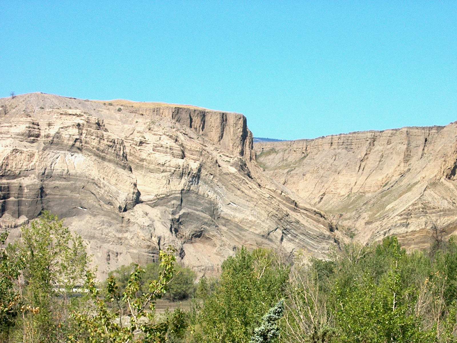
The Butte Ranch site also provided fantastic views of the sand bluffs created as the Thompson River cut through the glacial till formed when the last of the Ice Age glaciers were melting. The various coloured layers of sediment provided a natural canvas for nature to draw on.
We wrapped up the Ashcroft area, headed north the few miles back to Cache Creek, then headed east on the Trans Canada Highway aiming for Kamloops. We stopped at the earth cache called "A Burp in Time", located right on the highway. The McAbee Fossil Beds are the remnants of 50.2 million year old lake sediment; back then the area was not dry arid land like now. Instead it was subtropical, and a large lake existed here. Diverse fish and reptiles species swam here, many a precursor to today's existing species. The fossil beds originate in the Early Eocene period, where moon eyed fish, eosalmo (ancient salmon), and zeolites (microsporous crystalline solids) abound.
The area also has a great collection of hoodoos, pillars of rock with harder rock caps. The harder rock protects the softer composite rocks below them, leaving fields of vertical stack rocks which gave life to First Nations folk lore explaining hoodoos were invading warriors who broke a promise and were turned into stone.
Next stop was Juniper Beach, a small provincial park that allowed the public to get down to river level and camp among the cacti and juniper bushes along the cool river. The cache itself was a quick find, as long as you were watching where you stepped and where you reached - too quick and you had a hand full of cactus needles! The small park was a bit of an oasis on a hot day - shaded by the opposite river bluffs and cooled by the breeze off the river - probably like heaven on a scorching day.
Another few miles east on the Trans Canada Hwy brought us to the turn off for Wallichin - now all but a ghost town with only a few residents.
In 1907 it was an American's vision of grandeur along this section of river that gave rise to the current name. Charles Barnes envisioned the rich fertile ground providing scores of produce and fruit for the elite British society he planned to attract from Britain. In 1908 the families began to arrive, elegant homes and businesses where established, ground broken and subdivision parcels sold.
Chinese workers were hired to tend the fields and orchards, allowing the upper class British to live the life of leisure and luxury. By 1912 the town was well established with a bakery, a general store, barber, butcher, dairy, livery stables, ladies stores, two insurance offices, three laundries, post office and hotel.
Water for the orchards was brought via water flumes from 20 miles away from Snohoosh creek in the Deadman Valley. This was an engineering feat in its day but took a lot of maintenance but time was not on the community's side. World War 1 called back many of the British men to serve their country and the flumes fell into poor repair. With no water source for the fruits and orchards, the town soon died. On the bluffs to the north of the river still stand remnants of those very flumes - something to look at and wonder at the ingenuity of the people in their day.

A half hours drive brought us to Savona, a small community of the west end of Kamloops Lake. We did a few caches in the area but for me the prime cache was another Gold Rush cache called "Savona's Ferry". Francois Saveneux built a small one horse cable ferry to cross the narrow outlet of the lake as the trail to Cache Creek was so far just that, a trail. It wasn't until the Royal Engineers completed the construction of a Wagon Road in 1866 that a larger vessel was required. Over the years it had it's share of problems, with broken cables during spring melt causing the most problems.More than once the scow was washed downstream putting the ferry out of commission to the following year.
We hugged the south side of the lake as we picked up a few caches here and there in Savona both in the town area and along the lake shore. We kept up the pace as the day was getting on and we still had another 20 or so caches to pick up before we stopped for the night. A couple more hours of daylight would get us through some forest roads and back onto main roads before we ended our day night caching.
We were still west of Kamloops and west of the Coquihalla when we decided to do some scenic caching by taking a few of the Forest Service Roads in the area. The roads were all good graded roads and we passed a few cars here and there as they went to the more remote houses or farms in the area. Nothing memorable here, other than the enjoyment that back roads always bring - a hidden lake around the next corner, a herd of range land cows, the occasional deer just as surprised to see you as you are it!
We picked up a few caches with out going too far down the FSR, then turned around, went back along the Trans Canada and headed south on the Coquihalla for a few miles. There we took the Inks Lake Road turnoff and headed east along the road, actually another well graded FSR, and picked up a few more caches in this new area.

The one we all liked the best was at the site of an old log cabin; the cabin itself was situated in a clearing guarded by a swampy-when-wet area full of hungry skeeters just waiting for a meal. We picked our way through the soft wet ground, getting only slightly damp feet in the process, and walked into the clearing towards the cabin. This was one of those great scenic moments; the setting sun was low in the sky but still shining bright on the cabin, the grounds of the clearing sparkled with wetness and the cabin stood alone amongst the grass. I fired off a few shots from the camera, at this moment savouring the setting and the touch of history much more than the cache. But wasn't that the whole point of the cache being here....to bring fellow cachers to a scenic place to enjoy it as much as the cache owners does...
We continued picking up a few more caches and worked our way out to Lac Le Jeune Road and then headed north towards Kamloops. Night had now falling and I was feeling pretty good, actually kinda smug, about my route planning for the day. I figured we would have just enough time to pick up the last of the caches along the FSRs before night fell, and knowing that we would be doing our last caches in the dark I planned a route that would leave us doing caches close to the highways and a mile or two outside of Kamloops itself.

Our last cache had us doing a bit of circling back to be alongside the Coquihalla Highway again, only now we were on Sugarloaf Road travelling parallel to the Coquihalla Highway.As a matter of fact, our last cache was amongst the sage bush just a 100 feet from the busy highway. This was one of those caches that really made sure you know you were there....bits of spurs from the low ground plants blended with the sweet smell of sage on our pant legs and shoes, all under the light of a couple of flashlights and a BFL.
With the last cache of the day under our belt and the toll bells ringing 10.00 PM, we traced our steps back along Sugarloaf Road and headed along the freeway into Kamloops to score a nice warm dinner for our hungry tummies and pick out a hotel with a nice warm bed for our tired bodies.
To see the complete set of pictures from the trip, click here to go to my Flickr site to view the entire album.