After 18 years of service my 1998 Jeep has taken a rest. In its place is a 2016 Ford Edge. My love of exploring has not changed, and at the root of all my travels is the love of finding something new.
It's on these pages I've written travel logs to describe my wanderings.
I hope you enjoy the stories ...
Click on the pictures to view them full sized; after viewing click on the page to the left or right of the enlarged picture to return to the story
Day three we awoke in sunny Kamloops and began our day of geocaching at a "liar's" cache' this is a cache where everything about this cache is a lie, right from the size of the cache to the location and the finder's entries. These are always fun as they let the finder's imagination run wild, and it's always neat to read what other cachers write in the logs. In this case, the cache was a micro, so everyone wrote that the cache was huge, the location was an abandoned business, so every one wrote how it was tough to find a parking spot, etc. As a finder going looking for the cache with no preconceptions, the "idea" of where the cache will be found was skewed by the untruths written in the logs - makes you second guess yourself as to whether or not you're even in the right area of the cache itself!.
We did a few more caches in the city, some provided historical information from Points of Interest areas, some gave us geology lessons of the Kamloops area, and still some showed us you can put a cache pretty well anywhere!
One of the caches is located on a elevated pedestrian walkway leading up from a riverside pathway to a bridge that crosses the Thompson River. As it was a magnetic cache, you really have to trust your GPS and the cache hider that both sets of co-ordinates are bang-on. As it was, with a clear view to the birds up above, the co-ordinates were pretty darn close, but that still gave us 60 feet left to right of ground zero, and two sets of railings to search. We found it after 10 minutes of looking, which we didn't consider too bad, and for which we were pretty happy about.
Another nearby cache had us looking through three Ponderosa Pine trees, eventually turning up in what is known as a "typical Interior" hiding spot. I won't say what that means for those of you who have not experienced that type of hide - no spoilers here.
We spent most of the day chasing down city caches before we realized the day was slipping away and we needed to get the geo-truck pointed east towards Chase and Salmon Arm, our next stop for the night.
Heading east out of Kamloops we did a few caches here and there just to break up the drive; one of the ones we did was at Ducks, at a historical site that I knew well. Billy Miner, the train robber, committed the first train robbery in BC's history in 1904 near Mission BC. That location in Mission is just a few miles down Hwy #7 from my home base, so there was a bit of local interest for me as well.
If you read the historical marker in the picture above, you'll see that Billy Miner stayed in the Princeton area; as a matter of fact, he spent much time in the Merritt area as well on a friend's ranch, and often appeared at the Quilcheana Hotel for dances on Saturday night. He was known as a U.S. business man with a quiet demeanor and a fondness of dancing with the ladies. Having visited the Quilchena Hotel several times, and seen the old fashion bar in the small saloon with it's bullet hole and all, it was cool to be following in the foot steps of one of the characters from BC's history.
ABOVE: MrTJ at the Billy Miner historical marker just east of Kamloops in Ducks
ABOVE: TGUY98 at the Billy Miner historical marker just east of Kamloops in Ducks
ABOVE: Bowser98 at the Billy Miner historical marker just east of Kamloops in Ducks
Back on the highway we started putting a few more miles under the tires as we continued on heading eastward, picking up caches that were close to the highway or ones a little off the beaten track ifthey looked like interesting locations or caches. One of those neat places was just on the outside if Chase at a road side rest area that I have used a few times over the years. There is an information sign that informs travellers of the mountain goats that inhabit the steep cliff around the town; it's also right next to a small creek that offers travellers a much needed cool oasis during the hot Interior summers. The find itself was easy, and it gave me a chance to play with the camera a bit on the small waterfalls located here.
We scooted across the highway and took one of the feeder routes into the small town of Chase. We stopped at the 1909 Blessed Sacrament Catholic Church, which is now the town museum. Unfortunately an arsonist had a go at the museum and it is now closed while they await funds to restore it. The cache itself was missing, probably as a result of the initial clean up from the fire, but we did get to see a log cabin from the 1800's and a few small steam engines. Sorry to see the aftermath from the fire, although we did enjoy our short visit.
ABOVE: Fire scorched Chase town museum
We zig zagged through the small town of Chase doing a few caches in city parks and along roadways, losing daylight as we went along; we still had another dozen or so caches to pick up before we slid into Salmon Arm, so we skeedaddled back east along the highway knowing for the third night in a row we would be ending the day doing night caching.
Just before we lost daylight we stopped at one of the more interesting cache locations, this was at the now abandoned Squilax General Store; while it's life as a general store is now over, this building now houses the offices for the Squilax hostel. Just below the hostel are three old fashioned train cabooses that act as dorms for the hostel. The office buildings have been left untouched as there is a colony of Yuma bats that have been roosting here since the 1930's. It was good to see how the local community has supported the bat population in the area - many other peoples would have cared little for such yucky creatures as bats.
Oh, in case you were wondering, "Squilax" means "black bear" in the local First Nation's language.
Almost forgot, we managed to sneak in one more daylight cache worth telling you about; as we cached along the southern shore of the Shuswap Lake's system, we stopped in a small village called Tappen. The cache in mind was located at one of those old time cemeteries where it's beauty is in it's informal nature, unlike the sterilized ones you see in some big cities. The cemetery is located up on the hillside above the lake in the wide broad sweep of the Tappen Valley. It was evident even from our short jaunt here that this was a prime farm country, and the gentle winding country roads just begged for more exploration....sad to say it would have to wait for our next trip this way.
We had been keeping an eye on the time, not wanting to wait till too late at night to find a hotel in Salmon Arm; we also had an ear cocked listening to the local radio. We knew that a major storm system was buffeting the Salmon Arm area and points south and we knew we were heading right into it. My daughter and her fiance were holidaying in Kamloops that day and text messages from them indicated that this was a major lightning and rain storm causing wide spread flooding accompanied by power outages due to lightning strikes. We had actually been skirting the storm since dinner time when we pulled out of Kamloops; occasional bouts of rain told us we were just on the edge of the storm.
Not wanting to risk caught out in the inclement weather, we packed it in for the night and headed south the last few miles to Salmon Arm. Well, talk about good timing! About 2 minutes down the road we ran into the wall of the storm and were instantly driving through a heavy rain storm; to add to the poor visibility, we were driving through a few miles of freshly paved highway that was black as the night with no markings on the road way as of yet. All three pairs of eyes were glued to the roadway in case we drifted too far right and went off the shoulder of the pitch black road.
Soon enough we were in the growing town of Salmon Arm and starting the time honoured traveller's tradition of scoring a motel room for the night. That's a story unto itself, but we'll save that for another time.Suffice to say we managed to score a pretty nice suite at the Podollan Inn and Spas thanks to a free upgrade from the desk clerk, one that we very much appreciated and I don't mind putting a plug in for them. Two king size beds and a third queen size sofa bed with a large sitting area and a well laid out large bathroom with separate shower and tub was way more than these weary cachers expected, all at a reasonable price.
Time for another 10.00 PM dinner, then head back to the hotel and sort through today's cache finds and scan tomorrow's route, then hit the comfy beds for a well earned sleep!
Tomorrow would be Day 4 and the last day of the road trip for the Jeep Brothers......... To see the complete set of pictures from the trip, click here to go to my Flickr site.
Ashcroft was founded in the 1860's by the two English brothers Clement and Henry Cornwall. They originally came to BC to be part of the Gold Rush but on hearing stories of failed gold searches, decided to found the town to give future gold searchers a place to saddle their horses. The village of Ashcroft and it's 1600 citizens remain, as does Ashcroft House, a station house for the Cariboo wagon trains.
Click on the pictures to see the full size version
Like every small town, the original train station building stood in the centre of town, and knowing this, you can usually figure out where the first buildings in any town were located if you look for the train station. Here in Ashcroft it was still at the centre of town, and again, like most towns, the station has been refurbished to it's original glory. Only Ashcroft did it one better - they developed a block long park around the station with panoramic heritage displays of the history of the area, along with an old shack and a working water wheel.
A block down the street was the pioneer cemetery where our first cache was near; always neat to walk among the headstones and read the ages of those who worked this land before we came along doing frivolous things like geocaching. So many died young, and so many were from countries far away, lured to the new country by the promise of riches.
In the pioneer park with the train station was a short multi-cache that had you walking around exploring the history of the town via the displays in the park. This was an enjoyable multi-cache as it managed to casually get us into fine "geocaching form" for the day. We did a few more in-town caches which included some more of the Gold Rush caches - St. Albans The Martyr Anglican Church built in 1891, Harper's Grist Mill from 1878, and The Butte Ranch Site, circa 1860. We especially liked the last site, as this site was the location of a bustling ranch "town", complete with it's own school.
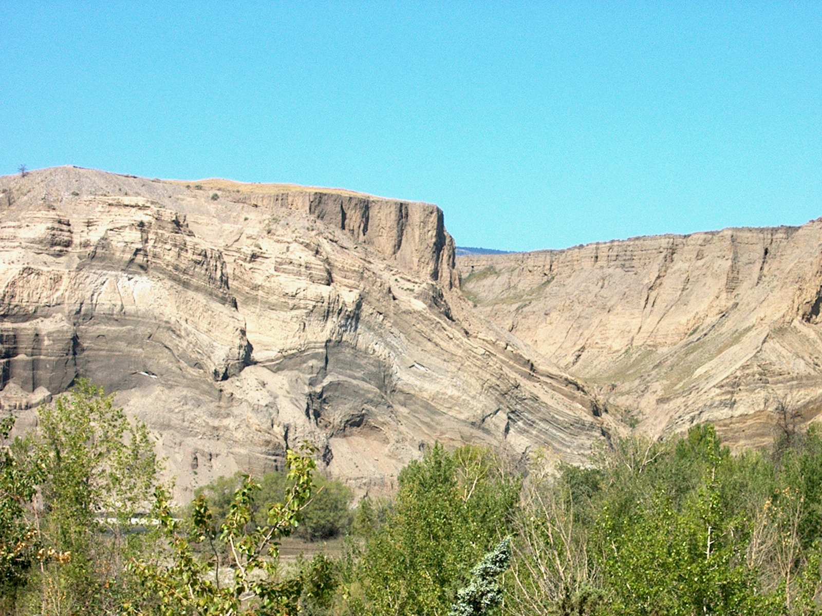
The Butte Ranch site also provided fantastic views of the sand bluffs created as the Thompson River cut through the glacial till formed when the last of the Ice Age glaciers were melting. The various coloured layers of sediment provided a natural canvas for nature to draw on.
We wrapped up the Ashcroft area, headed north the few miles back to Cache Creek, then headed east on the Trans Canada Highway aiming for Kamloops. We stopped at the earth cache called "A Burp in Time", located right on the highway. The McAbee Fossil Beds are the remnants of 50.2 million year old lake sediment; back then the area was not dry arid land like now. Instead it was subtropical, and a large lake existed here. Diverse fish and reptiles species swam here, many a precursor to today's existing species. The fossil beds originate in the Early Eocene period, where moon eyed fish, eosalmo (ancient salmon), and zeolites (microsporous crystalline solids) abound.
The area also has a great collection of hoodoos, pillars of rock with harder rock caps. The harder rock protects the softer composite rocks below them, leaving fields of vertical stack rocks which gave life to First Nations folk lore explaining hoodoos were invading warriors who broke a promise and were turned into stone.
Next stop was Juniper Beach, a small provincial park that allowed the public to get down to river level and camp among the cacti and juniper bushes along the cool river. The cache itself was a quick find, as long as you were watching where you stepped and where you reached - too quick and you had a hand full of cactus needles! The small park was a bit of an oasis on a hot day - shaded by the opposite river bluffs and cooled by the breeze off the river - probably like heaven on a scorching day.
Another few miles east on the Trans Canada Hwy brought us to the turn off for Wallichin - now all but a ghost town with only a few residents.
In 1907 it was an American's vision of grandeur along this section of river that gave rise to the current name. Charles Barnes envisioned the rich fertile ground providing scores of produce and fruit for the elite British society he planned to attract from Britain. In 1908 the families began to arrive, elegant homes and businesses where established, ground broken and subdivision parcels sold.
Chinese workers were hired to tend the fields and orchards, allowing the upper class British to live the life of leisure and luxury. By 1912 the town was well established with a bakery, a general store, barber, butcher, dairy, livery stables, ladies stores, two insurance offices, three laundries, post office and hotel.
Water for the orchards was brought via water flumes from 20 miles away from Snohoosh creek in the Deadman Valley. This was an engineering feat in its day but took a lot of maintenance but time was not on the community's side. World War 1 called back many of the British men to serve their country and the flumes fell into poor repair. With no water source for the fruits and orchards, the town soon died. On the bluffs to the north of the river still stand remnants of those very flumes - something to look at and wonder at the ingenuity of the people in their day.
A half hours drive brought us to Savona, a small community of the west end of Kamloops Lake. We did a few caches in the area but for me the prime cache was another Gold Rush cache called "Savona's Ferry". Francois Saveneux built a small one horse cable ferry to cross the narrow outlet of the lake as the trail to Cache Creek was so far just that, a trail. It wasn't until the Royal Engineers completed the construction of a Wagon Road in 1866 that a larger vessel was required. Over the years it had it's share of problems, with broken cables during spring melt causing the most problems.More than once the scow was washed downstream putting the ferry out of commission to the following year.
We hugged the south side of the lake as we picked up a few caches here and there in Savona both in the town area and along the lake shore. We kept up the pace as the day was getting on and we still had another 20 or so caches to pick up before we stopped for the night. A couple more hours of daylight would get us through some forest roads and back onto main roads before we ended our day night caching.
We were still west of Kamloops and west of the Coquihalla when we decided to do some scenic caching by taking a few of the Forest Service Roads in the area. The roads were all good graded roads and we passed a few cars here and there as they went to the more remote houses or farms in the area. Nothing memorable here, other than the enjoyment that back roads always bring - a hidden lake around the next corner, a herd of range land cows, the occasional deer just as surprised to see you as you are it!
We picked up a few caches with out going too far down the FSR, then turned around, went back along the Trans Canada and headed south on the Coquihalla for a few miles. There we took the Inks Lake Road turnoff and headed east along the road, actually another well graded FSR, and picked up a few more caches in this new area.
The one we all liked the best was at the site of an old log cabin; the cabin itself was situated in a clearing guarded by a swampy-when-wet area full of hungry skeeters just waiting for a meal. We picked our way through the soft wet ground, getting only slightly damp feet in the process, and walked into the clearing towards the cabin. This was one of those great scenic moments; the setting sun was low in the sky but still shining bright on the cabin, the grounds of the clearing sparkled with wetness and the cabin stood alone amongst the grass. I fired off a few shots from the camera, at this moment savouring the setting and the touch of history much more than the cache. But wasn't that the whole point of the cache being here....to bring fellow cachers to a scenic place to enjoy it as much as the cache owners does...
We continued picking up a few more caches and worked our way out to Lac Le Jeune Road and then headed north towards Kamloops. Night had now falling and I was feeling pretty good, actually kinda smug, about my route planning for the day. I figured we would have just enough time to pick up the last of the caches along the FSRs before night fell, and knowing that we would be doing our last caches in the dark I planned a route that would leave us doing caches close to the highways and a mile or two outside of Kamloops itself.
Our last cache had us doing a bit of circling back to be alongside the Coquihalla Highway again, only now we were on Sugarloaf Road travelling parallel to the Coquihalla Highway.As a matter of fact, our last cache was amongst the sage bush just a 100 feet from the busy highway. This was one of those caches that really made sure you know you were there....bits of spurs from the low ground plants blended with the sweet smell of sage on our pant legs and shoes, all under the light of a couple of flashlights and a BFL.
With the last cache of the day under our belt and the toll bells ringing 10.00 PM, we traced our steps back along Sugarloaf Road and headed along the freeway into Kamloops to score a nice warm dinner for our hungry tummies and pick out a hotel with a nice warm bed for our tired bodies.
To see the complete set of pictures from the trip, click here to go to my Flickr site to view the entire album.
"Summer time.....and the living is easy....." so goes the song.....a time when all is mellow and right in your world, at least for a few moments. But those moments live on fondly in your memories for years to come.
Such was a few moments in my life when my brothers Alan and Ken, AKA Bowser98 and MrTJ, decided that it was time to pack up just the three of us into one of the trucks and spend a few days doing a caching run up to the Interior of BC. We had done a similar trip a couple of years ago, and I for one couldn't wait to do another.
I have a Jeep TJ, Alan has a Jeep Liberty, and up until recently MrTJ also had a TJ, hence the moniker of "The Jeep Brothers" that some of our caching friends have bestowed on us. Well, I guess I've been called a lot worse!
So here was the plan; start the serious caching in Hope, cruise up the Fraser Canyon and finish off the day in Cache Creek. From there we would head over to Kamloops for the night, then on to Salmon Arm for the last night, and head back home from there. Well, we did pretty well just that, with lots of caching in between.
Now here's the problem....MrTJ and myself travel and cache quite a bit, so I've done lots of the ones up the Fraser Canyon. MrTJ and Bowser98 have done a bunch of the ones in Hope from a previous trip to the Interior, so now matter how we sliced it there was going to be some repetition of cache visits for one of us. Oh well, just do it and soon enough we'll be on to virgin territory.
We did most of the caches around town and the ones we liked the most were the ones along the old Kettle Valley Railroad right of way in the Suckers Creek area, a small marshland that lies between Kawkawa Lake and the Coquihalla River. The rail right of way is a smooth slightly graded walk about a kilometre long, which gave us plenty of time to chat in between spaced out caches. The history of the area was a big pull for us, to be able to walk in the footsteps of our heritage is always neat.
We especially liked the cache that was located at the heritage 1861 Anglican Christ Church; this gothic revival design building was built at the height of the gold rush in the area by the Sappers, as the British Royal Engineers were known. Besides administering to the hordes that came this way, it was also a strong reminder of the British presences in the area.
After grabbing lunch at one of the fine eateries in town, we began our northen journey up the Fraser Canyon. A couple of caches close to each other gave us a bit of a charge, each in their own way. The first was at the intersection of the highway and Nickel Mine Road. The cache was located just outside a private residence, one with an acre or two of wooded property; the cool part was the owner had salvaged many articles from the abandoned mine up the road for his house. Items like old bed frames, miner's picks and axes, mine helmets, lanterns and even a couple of old tractors gave the yard a great nostalgic feel...we would have loved to wander around his yard.
The other cache we liked was back across the highway and down at the edge of the Fraser River. One of the old time residents had left his property to the government, and the parks board has granted public access down to the rivers edge. I have to admit, this was a bit of a different view of the river for me; for most of the Canyon's length, travellers are high above the river looking down at it. At this new park we could walk down to a small sandy beach area and be at river's level. Oh yeah, there was a cache there too!
We headed on up to Emory Creek Provincial Park, where a campground was located on an old miner's camp. In 1858 the area was one of tents and miner shacks; When the gold just wasn't present in numbers they thought, many miners moved north up the Canyon looking for better pickings. After changing hands a few times, the CPR decided to make Emory City as the western terminus of the railroad; with this proclamation the town grew swiftly, counting thirteen streets, it's own newspaper, various shops, a brewery, nine saloons and a sawmill. When Yale was made the terminus instead of Emory City, the town died; just a few short years later by 1885, the town was all but abandoned.
I have to say, of the two caches we were looking for here we failed miserably! We couldn't even get close to one in the park above the camping area, and the other one by the river we thought must be missing. No one else has found it since, so we're sticking to that story. While thrashing around in the bush, on top of the hill above the river, MrTJ made a neat discovery; two wide rows of boulder size rocks neatly stacked up, the rows being approx 80 feet long each and about 4 feet high.
My first thought was we had wandered into one of the Native Indian fortification areas along the river used to repel raiding parties of other First Nations groups. Upon looking at the lay of the land, and realizing that these stacks ran perpendicular to the river, not parallel, I realized these were probably remnants of placer mining done by the Chinese miners; I've seen stacks like this in other areas, such as in Lillooet not far from where the Hanging Tree is located. For me, this was major cool - stumbling into a piece of hidden history was a great surprise!
We continued northward, stopping only occasionally to do a cache as MrTJ and I had already done all the caches in the Canyon, so we stopped for the benefit of Bowser98 to find the odd cache. In Boston Bar we stopped in town at a cache called "Cache, Cables, and Cars"; this one was a micro cache located on one of the old aerial trams that used to transport cars and people across the Fraser River from the Boston bar side to the North Bend side. Not so long ago the tram was still in use, until they finally built a bridge across the river.
We got into Lytton and started doing a few more caches, especially the Gold Rush caches put out by some of the small towns in the Gold Rush area. These caches are found in a geo-tourist book, each page giving a full historical recount of the area where the cache is located; collect 24 stickers from the caches and you can send away for a geocoin in the shape of a gold bar.
We hit the cemetery caches and showed Bowser98 around the small town, stopping for the always great view of where the blue water of the Thompson River meets with the muddy brown of the Fraser River. The Thompson water resists merging for a few hundred yards, but can't resist the influx of the mud bearing Fraser for long.
Off we went, the next neat stop being Nicomen Falls - if you haven't seen these falls before, they are spectacular. This 272 foot two step waterfall plunges out of an extremely narrow basalt gorge into a 400 foot amphitheatre gorge. The water flow is not great, but it is enough to have carved a sinuous, twisting slot through the basaltic rock formation, making the falls appear to spring from a cave in the middle of the rock wall. The best picture I have ever seen is from high above the fall's level; there you can actually see further back into the gorge from whence the waterfall springs.
We mosied on further up the highway; at Lytton we had left the Fraser Canyon and were now following the Thompson River as it travelled through the Thompson Canyon. In places the road was down almost at river level; here the road was carved out of the side of the cliff were normally the river would roar through at the height of the spring freshet. It is quite a sight to see, and can be slightly unnerving to see the wide raging river almost even with your car!
Spences Bridge brought us to a small community on the banks of the Thompson River before it heads south into the canyon. Here the river was slower, and prime steelhead fishing grounds. We stopped at a cache in a small rec type camping area that I'm sure exists solely for fishermen to camp and fish the river for steelhead. While here, Bowser98 noticed an old truck in the campsite that had been refurbished and was being used to haul a trailer. Bowser98 meandered over to have a conversation with them about the truck and to grab a couple of pictures for his Flickr albums; check out BC Road Relics for photos of old working trucks.
Anyways, after a few minutes of chatting turns out the owner is a fellow geocacher named tedylok; we've been chasing him up the canyon all day! We had a good conversation about geocaching and old trucks and life in general before we realized that, with night fall it wasn't getting any brighter, and we still had a bunch of miles to put under our caching belts before we made it to Cache Creek.
We found a few more caches in Spences Bridge in the dark, then started spinning the wheels on the F150 to get on our way to our final stop of the night. It was a shame really, as there are quite a few neat places to cache along this route but the night time made the locations "ordinary" and there were just too many caches still to do before we touched down for the night.
We bypassed the turnoff for Ashcroft and all it's caches, we would get to them in the morning. We headed on up the road a few more miles till we pulled into Cache Creek and picked off a few caches in the dark around town. Finally, around 10.00 PM, after being on the road and caching for 14 hours, we decided to call it quits for the night. We grabbed a really late dinner at the 24 hour A&W in town, then went in search of a hotel room where we could crash for the night.
Whew! Lots of story telling and it's only day one!! Man, I sure can spin a yarn! LOL
All pictures from the trip can be seen on my Flickr page here TIP - right click on link to open new web page
What a wonderful way to start my holidays - a hot summer day and a nice drive into Vancouver to have brunch and pick up some pastries, but not just any pastries.
Having been in Belgium a few weeks ago and being bowled over by the wonderful goodness of _real_ Belgium waffles served with a topping of whipped cream, chocolate and strawberries, we swore that if we ever found a place with real Belgium waffles in the Vancouver area we'd go there for sure.
Well, a month ago Annette does The Ride To Conquer Cancer from Vancouver to Seattle, and one of the food sponsors was a company called Patisserie Lebeau; they supplied waffles at the food stops during the day. Annette had them and said "these are real Belgium waffles"...luckily her friend Connie found the wrappings from a waffle and on there was the company name, address, web site...woo woo!
Annette looks them up and finds out they are in the Kitsalano area near the Burrard Street bridge. In the mean time Alan, one of my brothers, has been raving about this Danish bakery in Burnaby at Royal Oak and Rumble that have great pastries and have something called a Kringle. Well, we were also in Denmark, birthplace of the Pedersen clan, and we loved the pastries there....why not drive into town and make a day out of picking up some decadent treats that will help us relive our recent European trip by tantalizing our taste buds!
So, we set off from Maple Ridge into Vancouver and arrive at the Patisserie Lebeau just after lunch - a perfect time to have a late brunch and pick up some goodies to go. Annette ordered a plain waffle (are you kidding me!) and I ordered a waffle topped with whipped cream, fresh strawberries and fresh blueberries.....in a word - "AMAZING". Annette even helped me with my lunch by picking away at the fresh fruit so I wouldn't have to eat so much.
I was down to the last few bites when I thought "crap, I should have taken a picture"! Oh well, what can you do...it was hard to think with what was on the plate just begging me to dig in.
We finished up our waffles, licked the last of the whipping cream off my fingers, and stood in line to buy a couple boxes of frozen waffles, as well as a small crumb style banana cake and some cookies.
Now, on into Burnaby for the Danish pastries....
At Royal Oak and Rumble is The Elite Bakery, specializing in Danish pastries - this is where we came for the Kringle. It's a large pastry, kinda looks like a cinnamon bun only it's about 5 times as big. Lots of flaky pastry topped with sugar and thinly sliced walnuts. It's thin, not thick like a bun, and very easy to break off a section and wolf it down.....I mean delicately snack on a little bit of it at a time...
We made the run home in the car with the air conditioning up high trying to keep the frozen waffles and other pastries cool....I think it worked...I plan on having a pretty good waffle breakfast tomorrow morning and a great after dinner dessert.
Here are the links to the two yummy places: next time you're in town check them out. Annette's already stated that they are a "must" stop whenever we head into town in the future!
June 18 and 19 was the "Bike Ride to Conquer Cancer" - a 240 K trek starting in Surrey BC and ending near Seattle Washington. This is only the 3rd year for this event but it is fast picking up participants and status as a premier fund raiser: 2900 riders raised 11.1 million dollars! Not bad for the third year of a new event.......
The first year it was held, my darling wife Annette was planning on participating but she took ill with the very thing the fund raiser is for. Last year she was training for the ride although she was still suffering the effects of the treatments, and she had a nasty tumble off her bike and broke her wrist just weeks before the ride. As she had already raised all the funds for her entry fee, and as her friend Connie was going to ride with her, Annette decided to help out in other ways and went as a crew member. Needless to say, after missing the event for two years in a row she was rather disappointed.
Annette promised she would go this year no matter what, a bold statement as she is suffering still from the treatments. Many of you know that, as much good as the treatments do, you can't bombard the human body with that kind of abuse with out something being affected. In Annette's case it was her ability to walk properly; you gotta wonder if she can't walk with out pain, how is she going to ride 240k?
Well, as luck would have it, riding is a bit easier on the body than walking, so it was possible providing she could handle the pain. Annette and some of her lady friends from the gym got together, added a gentleman co-worker of one of the ladies, and Connie's husband Larry opted to ride unofficially again this year, same as he did last year when Annette was unable to ride. Me, I was the official shadow; I followed along in the truck and took video when I could to record their achievment. Hey, somebody had to take the video and I was the only person who owned a camcorder! :)
They fund raised the necessary monies and trained when they could on weekends and nights; the final ride they did was 70 miles, about the same distance as the days of the ride itself.
So, fast forward to Saturday June 18, and after a nice week of sunshine, they assembled in Cloverdale in the pouring rain! Not a nice way to start the ride ...they were cold and wet before the ride even started.
But full of enthusiasm, off they went on their great endeavour.
The first night's stop was in Mt. Vernon, the riverside park was full of blue tents for those that opted to spend the night on site. Many more, us included, choice to get a good nights sleep and camped out in one of the local hotels where the riders could at least try to dry out their gear overnight.
Sunday morning was marginally better than Saturday morning - instead of pouring rain it was a steady drizzle that got you just as wet. Still, the riders would not be deterred and off they went aiming for the finish line in Redmond. Another long day of country roads and hills...big hills.....more hills than the first day....and the end was within reach before you knew it!
I raced ahead of Annette and her team members and managed to catch Annette, Connie, and Larry as they came across the finish line. Annette was overcome with emotion and shed a few tears - so did I. Annette was so happy to be able to do the ride to not only raise funds for others, but to attain her goal of completing the arduous task of riding all that way. I am so proud of her, the determination and guts she showed to make it to the finish knowing all the time that she'll pay for it for days.....it just blows me away.
Here's a video I made of the ride - you can also view it on my YouTube channel by clicking on the link at the bottom of the left column on the page.
Where the heck has Ed been? No activity on his blog for a long time.....well, the answer is.....Europe! Just got back a few days ago from a combination holiday of one week driving from Belgium to Denmark, and then a second week of cruising in the Baltic Sea visiting Talin, Estonia; St. Petersberg, Russia; Stockholm, Sweden; Helsinki, Finland: and Copenhagen, Denmark. I'll have a lot more to write about later.
In the meantime, here is a short video I threw together of our visit to the Island of Aeros in Denmark, and the city of Aeroskobing on the island where our Father's father lived. The hamlet of Dunkaer, the church and graveyard at Risemark, and the area around Little Rise all are pictured here, as is the town of Aeroskobing. All are touchstones in our family's heritage, especially Aeroskobing; I was able to stand in the doorway of 18 Vestergarde, where my grandfather lived, and walked down the same cobblestone lined streets that my relatives did. That was pretty cool!
Haven't been out caching or back road touring much due to winter time, only managed to get out a couple of times past few weeks, so I thought I would look backwards and see where I've been.
I have been doing back road and forest road driving for close to 35 years, needless to say my knowledge of the South West corner of British Columbia is pretty extensive. On Jan 9 2005 I added geocaching to one of my hobbies, which dove tails nicely with my love of exploring the countryside and poking around little corners of the Vancouver suburbs and the Fraser Valley. Looking for geocaches is a good way of finding those hidden gems of parks, ocean vistas and high mountain views. Add in my love of photography and story telling, well, you have all the makings of a guy who goes every where and wants to tell every one about it! :)
I've expanded my way of getting my travelogues out as the years went by; starting with simple emails, then to writing trip reports for web site forums, to posting pictures on Flickr.com, then getting my own web space in the form of this blog, and finally adding videography to my story telling repertoire.
Let's see where I've been, stories I've told, and who's seen me......(I know, rather self-aggrandizing but there you are) LOL
Starting with this blog, which began on Oct 2 2006; 16,642 visitors have viewed 24,412 pages worth of 90 trip reports and blog write ups. Guests have come from dozens of countries, every where from Canada to the U.S., China, Argentina, the U.K., France, Netherlands, Italy, Australia, Israel, Russia, Austria, Columbia, Denmark, and dozens more countries.
My Flickr account consists of 1,959 pictures which have been viewed 30,154 times
My YouTube channel contains 52 videos I have uploaded which have been watched a combined total of 7100 times, give or take a few times.
On the geocaching front I have found 2,366 geocaches in 3 provinces, 8 U.S. states and two countries in Europe. Doing so I have logged 36,190 miles between caches.....thankfully I didn't walk it all! :)
As a way of saying thanks to the geocaching community, I have hidden 54 various geocaches. My cache hides are in such diverse places as your run of the mill shopping mall parking lot, where the busy area makes it difficult to retrieve the cache unobserved, to local suburban parks, to forest mountain roads treating the finder to fantastic lake views, west coast rain forests, and beaver ponds.
A lot of time has gone into documenting and recording my activities to share with my family, friends and colleagues, but that same type of force that drives my wanderlust also drives my story telling...I've had such a great time and seen some fantastic places that I just have to show and tell every one where I've been, whether they want to hear it or not! LOL
I hope you didn't nod off reading the stats, but when I look back on the journey so far, I'm amazed at the territory I've covered doing what I love - exploring BC and beyond!
Bring on the nicer weather and melt that snow in the mountains, me and the Jeep are ready to hit the road again!
Part 2 of our two week holiday was spent on a leisure visit of the southern section of Vancouver Island. We caught the ferry around dinner time on the Monday, which put us in Victoria around 9.00 PM. We cruised around till we found a hotel with wifi available (you old geeks in the crowd would call it "war driving"), then searched out the local phone number for a hotel right downtown that Annette had in mind. And a good score it was...
This time of year Victoria is a quiet town, most of the tourists have disappeared, the tree huggers don't like protesting in the cold and the rain, so we had our pick of hotels at prime spots. Annette got a sweet deal at a hotel a block away from the Parliament Buildings, and a short block away from where the Blackball ferry from Washington docks. A charming smile from myself got us upgraded N/C to a room overlooking the Inner Harbour, with a fantastic view out our balcony of the harbour. At least it would be come sunrise...
We went for a short walk around 10.00 PM in a lite rain on deserted streets near the Parliament Buildings and popped into a corner store for some cool drinks. We meandered back to our room at a leisurely pace just enjoying the quietness of a normally busy street, with no place to go and no hurry to get there. It was a good moment, walking hand in hand under the umbrella, with all our cares many miles away.
We had a lazy wake up, no rush to start the day as we were officially on "Island Time". I was still half asleep when Annette said "have you looked out at the view yet"? Well, no....I was still in bed! But, oh yeah, this will be a great view, with excellent shots for the video. Annette stands back, and lets me peek out the curtains....I rub my eyes as there's too much sleep still and I can't focus...then she starts laughing....I couldn't see a darn thing cause it was foggy as hell! Well, I started laughing too...best room I've had for a while in Victoria, good price with a great view...LOL
Oh well, whaddaya going to do, other than pack up and head on out towards Sooke, someplace I had yet to be. The fog slowly lifted and the sun came out to make it a great day for the start of November - it was so warm that we had to take our coats off in the car, and the outside temperature hovered between coat or no-coat.
We grabbed a bite to eat at Timmy's in Colwood and wandered up Metchosin Road as it followed the coast line. I sure like these drives a lot better than the main highways - there is much more to see and more opportunities to pull over when ever something sparks your interest. We went past the town of Sooke for a few more miles, and picked a random place to stop where the highway touched the water...somewhere along the length of Sooke Bay.
The sun was fully out now, doing it's best to warm our hearts, and the shoreline did it's best as well. We walked the few yards to the beach, sat on a log and just enjoyed the sights and sounds for a few minutes. The place was enchanting, so much so that a brief stop turned into a couple of hours spent sitting on the beach acting like boyfriend and girlfriend again...in a good way! LOL
The beach here was full of small pebbles, and the shoreline short and steep; when the tide pulled out, it pulled all the small pebbles with it. Under the quiet roar of the undertow, was the unmistakable sound of pebbles tumbling over themselves.
Sadly, we knew there was more to see, so we trudged back to the car and turned the car back towards Sooke. I wanted to find at least a few geocaches while we were on the Island, so I had several picked out close to the road as we travelled the Island. The first one on my list was in Sooke, on a quiet back road.
So, picture this....we've been on holidays for a week already, we are on Island time with no rush to do anything or go anywhere, and I have only one thing "I" _want_ to do today...that's to find a cache. So, funny enough, the missus, who shall remain nameless, immediately starts by saying "how far down this road do we have to go", "we don't have all day to waste caching"! Excuse me? I thought we were in "relax" mode...apparently not when it comes to something she has no interest in....so we go about 6 blocks down this road (that's not really far is it?) and we pass a small trail into the bush...GPS says 130 feet to the cache. I park on the side of the road, GPS says 86 feet to the cache...I have one foot out the door and someone in the car, who shall remain nameless, says "hurry up"! I say "shut up, I haven't even gotten out of the car yet and I only have to go 80 feet" ! Sheesh! Isn't this the same person just a few days ago had me sitting on a bench guarding her purchases for 3 hours as she power shopped at the Outlet mall in Portland? Hurry up my ass!
With that little incident out the way, the drive went without further excitement as we went back through Sooke and caught the Inner Island Highway up island. We cruised up the Malahat Highway stopping at the viewpoint to take some pictures and video, and just enjoy a few moments out of the car. We continued north, getting off the main highway where we could to drive the old roads along the waterfront. This was way more funner! :) We drove through small towns like Mill Bay that displayed its rich fishing heritage for all to see. Fishing nets hung off the side of small houses pushed right against the old road, with pylons for footings to hold the house over top of the shoreline. Where space permitted, boats big and small were tucked between neighbour and house.
We got off the main highway again at Cobble Hill Road and took the old road down into the old town of Cowichan Bay right on the waterfront in, what else, but Cowichan Bay! There is a lot of First Nations history here, as it is one of the main First Nations settlements on the Island pre-European contact. For thousands of years, the people harvested salmon from the rivers and shellfish from the tidal flats. Warm winters and plenty of wildlife made this an ideal place to live.....and still does.
We ended the day's drive in Chemainus, another bright tourist stop during summer months but quiet on this Autumn day. Chemainus was an old logging town that was dying like most logging towns did in the 1980's. From it's inception as a First Nations village, to it's dynamic times of logging, mining, and fishing, the town was all but dead when the last lumber mill was scheduled to close in 1983. In 1981 the town decided to beautify itself and at the same time attract tourism, by painting murals on the sides of businesses. They started with 5 murals, today they sport 41 murals, plus a scenic little old fashioned, downtown section. It has now become a main tourist draw on the Island itself, and the little town is choked with tourist cars, RVs, and tour buses in summer.
Being here in Autumn, gave us the town pretty well to ourselves; and, as we discovered, there was a new Best Western hotel in town, only a year or two old. It looked like the only people staying there were a few blue collar workers and a few old tourists also enjoying the off season. Again, my charming smile along with a casual request for some kind of "free" upgrade brought us to the top floor in a corner suite. And what a great little room it was...you walk in, bathroom by the door, walk down a short hall, bedroom is on the right hidden behind double doors, a full kitchenette tucked off to the side of the spacious living area, and a large walk out balcony where you could sit out in the morning and enjoy your eggs and orange juice on a warm day! I definitely made a point of saying "thank you" to the young lady at the reception desk - that was a great gift from the hotel!
In the morning we had a lite breakfast at the hotel, then wandered around the streets taking in the murals and popping into the small shops advertising some typical touristy stuff, and some fine crafts made by local artists. We even went into the theatre they had, not so much to see the theatre, but the higher end gift shop stocked by local artists with small items like jewelery, up to paintings and metal work. Hmmm, that place wasn't quite for us....some prices seemed way over our heads. Still, I'm sure the workmanship was worth the dollars they were asking.
The day was getting on, and we had to start getting on as well, so we did get on up the highway, next stop, petroglyphs! I had gotten my eye on a small park advertised in the local Parks map and wanted to see in real life some petroglyphs..had only seen a few to date. Just a couple miles south of Nanaimo is Petroglyph Park, a 2 hectare park right at the side of the main highway overlooking the Nanaimo Harbour. The earth here is mostly exposed smooth rock, perfect for First Nations to use as a tablet to tell their stories.
First question I had - what's the difference between pictographs and petroglyphs? Well, I had to look that up, as they seemed the same to mean...here's the difference.
Rock paintings are called pictographs - rock carvings are called petroglyphs. Now you know!
I pulled off into the small parking area looking forward to the rock carvings; Annette chose to stay with the car, partly as she wasn't as interested as I was, and partly due to the local crime fighting sign that stated "Thieves work here". As it was, it was a very short walk up to the top of the large boulders above the car, and there I could see the rock carvings. The Park has done a good job of highlighting the carvings, and interpretation signs help the visitors. What I was disappointed in, was the fact there had not been any maintenance done in the park for some time. Fallen leaves and moss obscured the petroglyphs - I guess this was one down side in coming out of season - no work was done for the visitors sake.
Back on the road, we took the Old Island Highway north and stayed near the water again, this time passing through Lantzville, Parksville and stopping in Qualicum Beach for lunch. We headed up the hill away from the water into town and found a trendy tapas bar restaurant with good sandwiches. A nice lunch in our bellies, we headed back down the hill to the water, and continued our sojourn at waters edge.
Through Fanny bay and Oyster Bay, with their oyster operations creating mountains of white shells besides their buildings, and the strong smell of seawater from the concentrated operations, we marched on up island, until we got to the turn of for Cumberland.
Cumberland is an old coal mining town that has been nearly dead for as many years as I've been coming to the Island. Annette use to visit a good friend here back when they were both young girls, and she always wants to poke around town to see how it's changed. Well, if any thing, it's deader now then back then...although there is the odd sign of new life here and there as the town becomes an alternative place to live for the folks from the bigger towns of Courtenay and Comox as they look for cheaper housing.
We did a quick tour of the town, all 8 blocks of it, then headed back to the ocean to have a look-see around Courtenay. Like many parts of the Island, new shopping malls on the outskirts of town indicated a growth spurt that we hadn't seen before. But the downtown core remained pretty well the same, as many towns do.
We crossed the bridge out of Courtenay and drove the couple of miles to Comox, sister town of Courtenay and home of the large CFB Comox at the Comox airport. We looked around the air force base, taking pictures of some of the old planes on display in a museum area. Problem was, we couldn't get in to tour them...end of tourist season....bah!
We meandered over to the museum itself and spent a couple of hours looking at the vintage air force equipment, from the WW1 goggles worn by pilots in open cockpits, to the radar set ups of yesteryear, to the plane-dropped torpedoes on display....which Annette wouldn't let Ed kick to see if they were real!
If you are in the area, check it out; entry is by donation and I bought a CFB Comox golf shirt to help the cause.
Another must do in the area is the Courtenay Museum and Paleontology Centre. For many years the museum was a typical small town museum, doing it's best to preserve local history. The history of the Courtenay-Comox area goes back many years - the latest event for mankind was the visit by Captain George Vancouver in 1792 aboard the HMCS Discovery. Recent findings suggest that an even earlier visit by Sir Frances Drake in 1579 was the first real European contact for the First Nations people. Thousands of years before a sail ship entered Comox harbour, the People lived well off the abundance of deer, bear, beaver, salmon, whales, and shell fish.
And, millions of years before the People came, dinosaurs roamed Courtenay. Not too many years ago, a startling find on the Puntledge River led to a boon in fossil hunting. An elasmosuar skeleton was found by the river; this set off a boon and many more fossils were discovered, from the smallest of creatures called trilobites, to gastropods and bivalves, all the way up to the giant elasmosaur. Courteany had it's calling card, and another tourist draw to help the town.
For Annette and I, Courtenay held another treasure for us...our old friends Ron and Donna Mae had moved here from Maple Ridge a few years back, and no trip to the Island would be complete with out a visit. I worked with Ron back in the old Westinghouse days in 1976, and it was clear even back then that Donna Mae was the smart one in the family...so naturally I hung around with Ron as he was more my speed! :) Ron use to be my shotgun partner back in the days when a Sunday drive with Ed meant you never knew where the hell you where going or when you would come back. Our wives received more than a few calls at dinner time from us to say something like "we're in Ashcroft but will be home soon". The response was always "what the heck are you doing way up there"?
Ron is fond of telling a story of spending a day with Ed in the Jeep going into the mountains along Harrison Lake and driving for miles and miles on forest service roads only to have Ed ask him "want to stop for coffee"? Ron thought "where the hell are you going to stop for coffee in the middle of the bush"? Ed says, "wait 10 minutes". A few miles down the road the Fraser River running through the wild and dangerous Fraser Canyon came into view and Ron said "where the hell are we"? We had crossed over from Harrison Lake to Big Silver Valley, passed through the Kookipi Canyon and entered into the Nahalatch River system through the back door, getting deposited on the banks of the Fraser River at Boston Bar. I think that trip really blew Ron's mind...the fact that you could go into the Coast Mountains near Vancouver, leave one biogeoclimate zone, cross the Coast Mountain Range, and come out into the Interior Desert biogeoclimate on the back end of the Interior Mountain range. Or he could have just been amazed I knew where the hell I was! LOL
We had a great visit with our old friends, they are the type of people that even though you haven't seen each other for a few years, it's like you never left each others company. A nice cup of after dinner tea at their house, followed up by a lunch at the White Spot the next day helped us catch up on each others lives and what "the kids" where doing.
All too soon, we had to say goodbye to our friends, (definitely the hardest part of the trip) and goodbye to the Island as we were running out of days. We took the new Inner Island Highway from Courtenay to Nanaimo in a bid to catch one of the late ferriesback to the mainland. Let me tell you, the new highway is just like driving the Coquihalla - the same people who made the Coq must have had a hand in the Island highway. It's 4 lanes, it's mostly straight, and it's fast. A 2 1/2 hour trip now took only 90 minutes if that, and we couldn't believe how fast we got down island.
Well, a late ferry out of Nanaimo let us get back home in Maple Ridge around 10.00 PM, just enough time to play with the cat and enjoy our own bed.... ahhhh....
If the video is too wide for your screen, view it hereon my YouTube channel