 Hosted by Ed Pedersen
In attendance:
Mark Woodside & Alina Smolyansky from Vancouver
Richard and Jan Leek from Portland
Cheryl Steele from Everett
Ken and Linda Pedersen from Maple Ridge
Right about the time I was bumping and crawling up a steep rocky hill in 4 low I was thinking how glad I was that I advertised this trip as a 4X4 trip only. Most of the trip could have been done in two wheel drive, but 4 of the miles in the middle of the trip consisted of pretty rough road. A clue was when my cup holder fell off the door spilling it's contents on the floor for the third time....
We left the rendezvous point pretty well on time, well, the term "on time" is flexible according to Ed's standards. We gassed up and headed towards Harrison Mills, our entry point and mile zero of the long forest roads we were to follow for most of the trip.
The south end of Harrison Lake is five miles to the east of Harrison Mills, but the West Harrison Lake FSR starts on the west side of a small mountain in Harrison Mills, heads north, then rejoins the lake arond the 10 mile marker. We stopped at the start of the gravel road for last minute instructions, such as spacing out between vehicles to keep the dust down, and to ensure we were all on the same frequency on our CBs.
I had previously been on trips with most of the people who came out for this ride, except for Mark and Alina. They were out for the first time, and I think Mark was surprised when he asked if I had a map, and my reply was "don't worry, I'm a trained professional...it's all in my head!", ...he must have thought we'd be getting lost for sure !!
We headed up the popular FSR amid a freeway of cars coming and going along the first part of the route. Viewpoints were hard to come by for the first stretch, but when they did the views were wonderful indeed..deep blue waters showed the depth of the glacier carved lake that we would be driving along for the next 50 miles.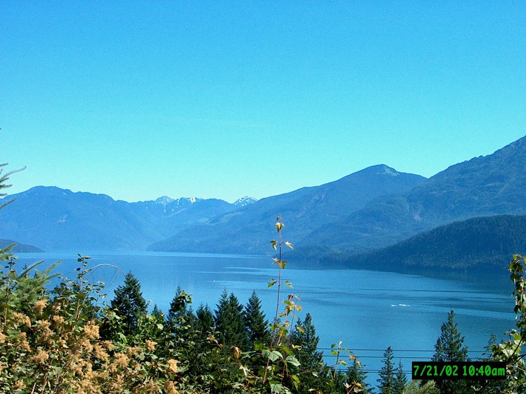
We drove along through mature second and third growth forests. This area was the sight of a vast railway logging operation at the turn of the century, and still supports a large logging operation in the surrounding area. We stopped at the newly renovated campsite located at 20 Mile Bay. The original campsite was close to the road on the side of the hill: the new one was right down at the edge of the lake on a peninsula of land. The new spot is clean, the shallow waters of the bay at the campsite are warm and kid friendly, and the campsites are in the shadows of the trees, but subject to a breeze to help cool off. We had a leisurely early lunch, then got back into the vehicles and headed further down the road. This was the stretch of road I was concerned about. In the past the FSR from here on was not maintained, and several wash outs had made the previous trips somewhat adventurous. Well, now the logging company has opened a new area to log further up the lake, and they have made the FSR into a main line, and it was smooth as silk. That is, until we were 4 miles from the end of the lake. The good road turned off the old West Harrison FSR, and headed up the mountain to the current logging areas. We had traveled through some active logging right at road side, but it was not the main logging site.
The further up the lake we went the more rugged the mountains became, and the blue water at the south end of the lake was slowly becoming more green as we got closer to the lake head. Here the emerald green waters of the Lillooett River carried it's colouring into the lake and extended it's reach for some miles out into the waters. The Lillooett is fed by glaciers on the surrounding peaks, and we could see remnants of those winter snows still defying the hot summer sun on the high, cragged mountain tops on both sides of the lake.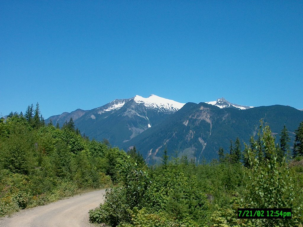
Well, about the same time the scenery starting getting our eyes off the road, the road went from good gravel to a deteriorated road bed....the FSR had several washouts and some of the long steep sections had small creeks flowing down the road, washing away the surface layer, and leaving uneven bedrock and small to medium size rocks for the 4X4's to bump and grind over as we used 4 low to either crawl up a hill or crawl slowly down a hill. It was at this very moment that I was glad I trusted my instincts and said "4X4 only for this trip", right before that darn cup holder went under my feet again.....
The rough section didn't last too long, and before we knew it we had crossed over to the next tree license area, and the logging camp at the north end of the lake had pushed a spur road south towards our location. A good graded road signaled that we had made it through the worst of the trip, and we shifted out of 4 low and cruised the last mile or so in comfort.
We drove down the last hill into the active Tipella logging camp. We came in through the back door, so to speak, and we drove through the large dry land sorting area towards the main offices and work buildings. 
I was surprised at how empty the dry land sort was; while they had a fair amount of inventory boomed in the lake, lots of bare ground was showing in the yard. I think this is because of the current tariff war between Canada and the US. The Canadian industry has lost a large share of their market in the U.S., and there are thousands of laid off workers because of it. Generally yards like this are overflowing with stacked products awaiting sorting and grading prior to shipment.
As it was Sunday the camp was shut down, and we drove through unhindered, not having to worry about avoiding large grapple movers and logging trucks moving about. The other benefit of the weekend is that we did not have to worry about meeting a logging truck head on over the next 40 miles of FSR.

The camp was the official end of the West Harrison FSR, and the start of the Pemberton-Lillooett FSR, officially known as the In-SHUCK-cha FSR.
As this was now the main haul road north towards the mills in Pemberton, the road was in excellent shape but there was a trade off....DUST !!
Soft billowing talcum powder dust was to be our friend for the remainder of the gravel FSR. We spread out as far as possible in the convoy to allow the dust to settle, but that didn't work when we would pass a vehicle coming the other way. Then we would quickly roll our windows up, but that too was useless in deterring the inside of the 4X4's from being covered in a layer of white dust.
Three miles north of the camp we passed over the Sloquet River. It is 8 miles up this side valley to where the Sloquet Hot Springs reside, the same Sloquet Hot Springs that I have talked about before on the list. Another couple of miles and we took a side road that returned us to the head of Harrison Lake, only this time we were on the east side of the lake.
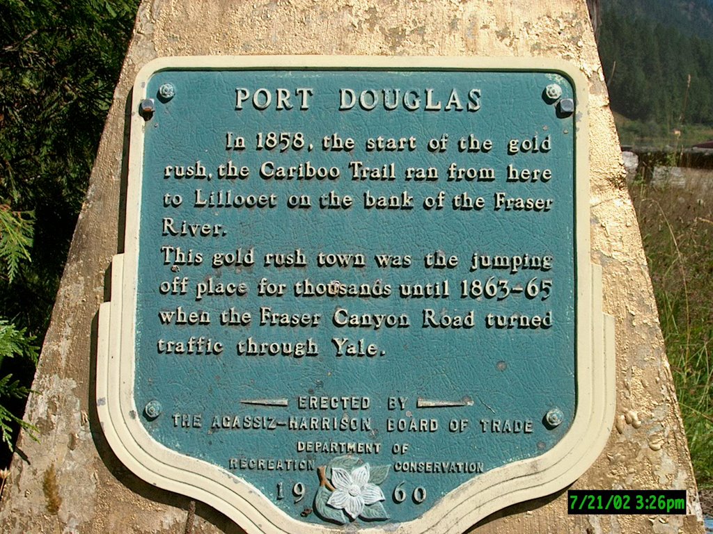
Port Douglas was the head of navigation for steamers from the late 1850's to the early 1860's. This was the first of four lakes that made up the Gold Miner route called the Douglas Trail. It was named after Governor Douglas who ordered a port to be built at this location. A city soon flourished to serve the needs of the hordes of passing miners. Being a frontier town there was no shortage of troubles and the crown colony of BC sent one of their judges to calm things down.

Judge Matthew Begbie was know as the Hanging Judge. He was 6'5" and solid like a rock..legend has it he saw a street fight where one fighter was taking on all new comers for 20 bucks...story is he took up the bet and knocked the man out cold. He gained a lot of respect that day!
When we first got to the hamlet of Port Douglas I jumped over a low fence to look at a historic marker in some ones front yard. Before long two dogs came running out and a lady was following after them. Turns out she is the caretaker of a metals research camp that now occupies most of the old downtown section of Port Douglas. She was nice enough to invite us onto the property and gave us a first hand tour of the camp and it's buildings, as well as supply us with some local history.
On the back of the property there was an old stone foundation that used to be the courthouse from the 1860's, and across from it was an enormous cottonwood tree that a man convicted of murder by Judge Begbie was hanged. Unfortunately, like most towns from this era, they had a major fire in 1894 that leveled all the wooden buildings. This lady spent a good hour with us and was most generous with her time, she really added a good historical footnote to our Gold miners trip for the day.
Back on the road we soon realized what it feels like to have some one pour bags of flour over your head. This section of the country was warmer and dryer than the southern end of the lake, and the roads here were wide and smooth, but covered in 4 inches of floured dust. All that dust kicked up by 5 vehicles traveling at 30 miles an hour, it doesn't take long to figure out what we looked like and felt like after this section of the road.
We were now on the east side of the Lillooet River, and it had that deep emerald green that comes with heavy concentration of glacial flour. We drove for many miles strung out a mile or so apart to give the dust a chance to settle, and trying to find the right spot between "not too far apart" and "not too close".
 As we drove along the mountain views were spectacular; every turn of the road brought a new glacier, or a new jagged mountain peak to view, or the river would have a few more twists that would make the water sparkle in the sunlight. I stopped often snapping pictures, all the while trying to maintain the distance from vehicle to vehicle. Eventually the valley opened a bit, and along side the river we found the Indian settlement of Skookumchuk, which means "fast water" in the Interior Salish tongue.
The Reserve boasts a picturesque three tower church that is approx 100 years old. I've seen pictures of this church in many backroads books and web sites on the Vancouver-Southern BC area. Shortly after the Reserve we came upon St. Agnes Wells Hotsprings, administered by the local Skookumchuk Indian Band and supported by the Abernathy family, one of the pioneer logging families from the Fraser Valley.
 St. Agnes Wells was the site of a hotel built to serve the miners and entrepreneurs that struggled along the Douglas Trail in the 1860's. It was named after the founder's daughter, Agnes, whom he obviously thought a great deal of.
They have done a great job on the camp site and the area around the hotsprings themselves. Originally there was one large rock pool made at the base of the small cliff from which the hot springs originate. Now they have two large bath tubs covered with A frame shelters, each of the tubs large enough for 5 people. They also have a tub of in the corner of the springs near a bush area, and another wooden one person tub right on the tiny creek that flows through the clearing. Even the campsite is wide open and spacious. It's actually a clearing amongst the trees, pitch your tent where you like, either close to the pools or 100 feet over on the edge of the emerald green Lillooet River.
 We spent some time here, I think all wishing we had brought our swim gear, although, like most country hot springs this one was clothing optional.
Back on the road we once again got the pleasure of eating the voluminous clouds of fine dust, and what a joy it was.....Another 30 minutes down the trail brought us to the start of Lillooet Lake, and it was the same green that the river itself was, only this time the visual plane of green was as wide as the valley.
We paralleled the lake for many miles, keeping one eye on the lake views, and the other on the narrow one lane road as it ran along the base of the cliff at water level. Eventually we neared the north end of the lake, and here the valley was wider with more land at the edge of the lake.
We passed several Forest campsites along this section of the road, but my favourite was back at the hot springs. Another half hour of travelling and we were getting close to the end of the gravel forest service road. We had good CB communication as the valley was wide open and the terrain flat along the lake, and we counted down the mile markers to one another to keep a bearing on where we all were along the road.
It was with some relief that I called out "the leader is at mile zero and on pavement"! No more bloody dust up my nose and in my shorts !! I should have stripped down and jumped in the tubs back at the hot springs and to heck with modesty.....
We assembled at the end of the trail, and did our best to do a quick wash up of faces and hands to feel somewhat clean, and then headed a few miles down the road to the town of Pemberton to gas up and grab fresh drinks.By now it was 7.00pm, and we had been eating dust and rattling the 4X4's around since 10.00 am.
Over 110 miles on two Forest Roads covering just half of the historic Douglas Trail, and that was plenty enough for us. We lingered at the gas station reflecting backon the day, and we all agreed while it was harder on us then vehicles, we were all glad we had come for the day.
We convoyed south through the ski resort town of Whistler, and stopped at Squamish for a burger and drink that constituted a 9.30pm dinner. Again we convoyed south, now in the dark along the scenic Sea to Sky Highway, heading for Vancouver. Even in the dark the near full moon reflected on the waters of Howe Sound, lighting up the waters with it's glow.
11.00 pm and three vehicles were back in Maple Ridge, 10.00pm arrival for one to Vancouver, and CJ drove straight through to Everett and home, with her usual set of troubles to tell us about...
On the way home her soft top on the Jeep thought that 12.30 am on the I5 was a good time to start coming off.....I guess it had finally had too much banging around for the day, and rebelled...
This was a VERY long and tiring trip, which I knew it would be, as did the participants, but they still came out anyways. Through it all we kept our sense of humour and enjoyed the day, but I know we were all glad to head home after this one. My thanks to all who came out for the trip, I enjoyed all your company and was pleased to have a few extra folks along to show them the great scenery in my "backyard".
4 comments:
We did that road today, well until the first major rut about a kilometer past the first washout. We were not really wanting to go any further as we didn't know that our vehicle would be able to handle any other snags along the way. We may attempt it at some other time with a different vehicle, but it won't be for a while.
My Husband and I just got back from a weekend at 20 mile Bay. It was beautiful. We had been avid 4x4ers for some time and are going to be taking our Pathfinder on the same trip. We will make our's a 4 day trip instead of a day trip. We will stop here and there for a night and then carry on the next day. Your article was fantastic. Thanks for the info.
Kristin
Kristen, i think I seen you and your husband at 20 mile! I was there with my three kids and asked you for directions to the creek nearby. Small world.
Marko
Hi Kristen! I think I seen you at 20 mile bay. I was only there for a lunch break. I was with my three kids and I you brought out your map to show me how to get to Hail Creek. It was nice meeting you guys.
Marko
Post a Comment