Monday, October 15, 2018

East Coast Cruising - Kennebunkport Maine


This portion of the shore excursion was titled "Portland and Kennebunkport Maine". In reality it was a fly by of an ordinary mid size town called Portland with a stop at picturesque Fort Williams Park to see the lighthouse and military battery, and then off we went down the road to Kennebunkport.

Kennebunkport is a name that sticks in your mind as it is an odd name to start with, it also associated with American President's names as it is a fave recreation place of many presidents.


It is a very pretty town, kept pretty I'm sure for the hordes that come here every day aboard cruise ships like our own, and from the wealth of the local citizens.

The houses on the edge of town are well tended, and many houses hint at their original function as true summer houses for the well to do. Two story wooden houses sit on an acre or two of land, old trees front the yard with swings hanging from a lower branch were possible. You can still imagine kids playing on the swings while adults picnic in the grassy front yard.

The tour bus dropped us off in a back lot off Main Street and we were free to wander for an hour to spend as much money as we could to help the local economy.
As I stated, the town is pretty and you can see the amount of money spent on buildings and paint and sidewalks and lighting and everything else that goes into making a town tourist friendly.


The town is a typical tourist trap but we still enjoyed wandering in and out of the shops, and we found some good kid stuff to buy for the grand kids as things Grandma and Grandpa brought back from their "boat cruise"
Soft lobster stuffies and sea side hats were the items that were purchased and stuffed into the back pack to be carted back to the cabin for packing into suitcases.

The hour went fast and soon enough were were back on the bus for the 45 minute trip back to the ship.

On the way out of town we took the sea shore route and passed a beach where Barbara Bush walked every day. It's said that she would have her Secret Service men walk up on the sidewalk so that the towns folk would not be afraid to stop to talk to her. And they did regularly - the town loves the Bush family and vice versa.

Barbara Bush would often sneak into the local area hospitals in Portland to read books to the kids in the hospital. There was no fan fare involved, no photo ops, most of the time no one knew she was there. She would just come in to read to the kids to brighten their day.

We went past the Bush family compound which sits on a small peninsula on its own. George H and George W, as well as Jeb and other family members. The Secret Service enforce the "no stopping" policy on the road that winds around the compound. It took all of 30 seconds for a couple of tourists whom stopped to take a picture to have a big black Suburban leave the compound and make it's way over to them to move them along.

So, a short spin around Portland, a trip to Kennebunkport for a bit of shopping and sightseeing, then we were back on the point in time for dinner.
The meals were consistently good, at times really good, and we were beginning to look forward to dinner times.


 It was Ken and Linda's 41st wedding anniversary, so Annette and I bought them a bottle of champagne to celebrate their happy day, as well as a fun cruise with family.


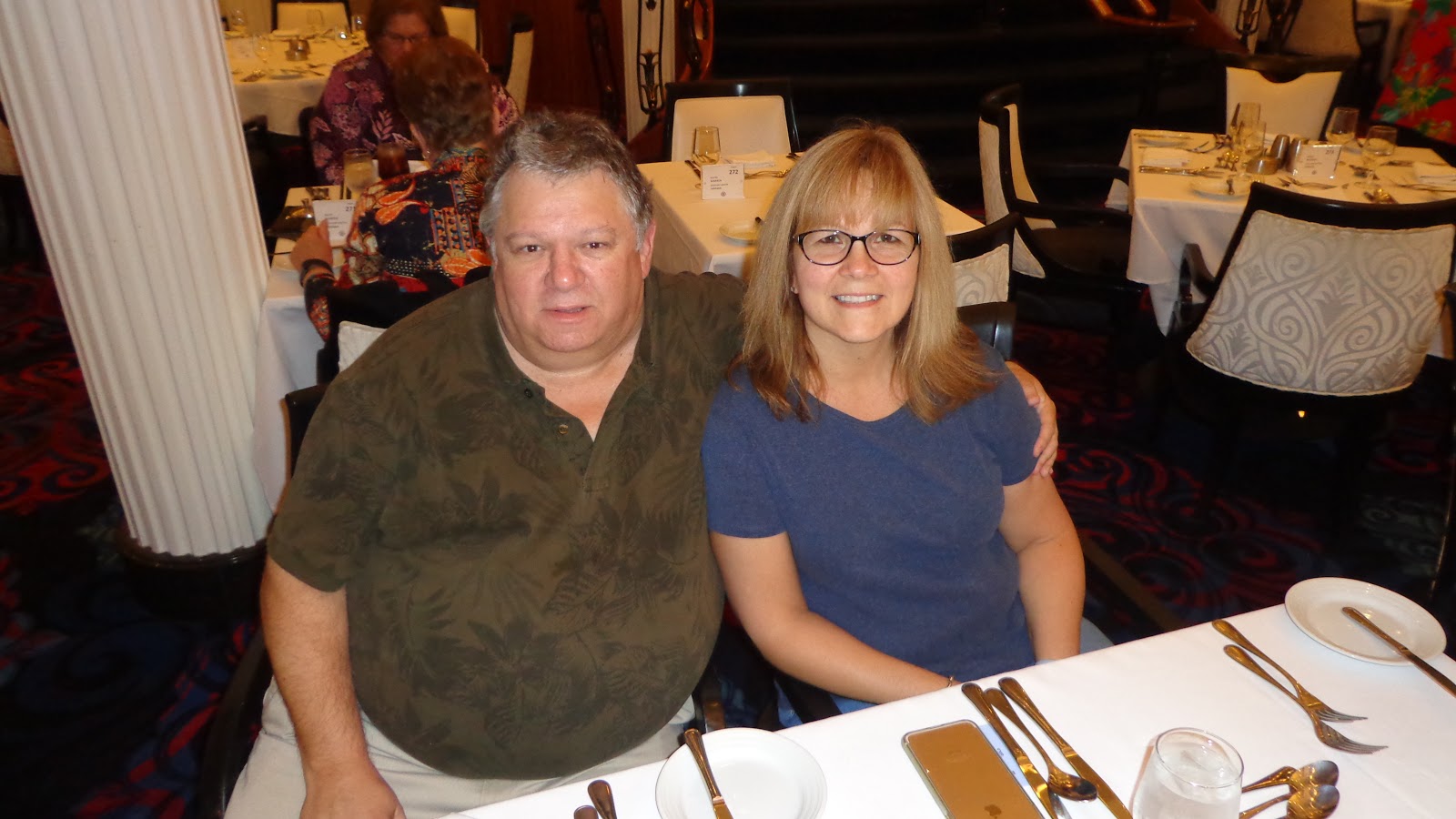
For Annette and I, every day is a wonderful day that we are together. Yeah, right she says  :)

And you are right as well if you just said "not many pictures here"
I only gave a couple of teasers.I know, what a pain I am.  :)

All of the pictures of Kennebunkport can be found here on my Flickr site.   


Friday, October 05, 2018

East Coast Cruising - Bar Harbor Maine


September brought a cruise to the East Coast for Annette and I. We started in New York, visited two cities in Maine, then sailed over the International Boundary into Canada and visited several cities in the Maritime region. The cruise ended in Quebec City and we ended our holidays after spending time in Montreal.


CLICK ON ANY PICTURE TO SEE THE FULL SIZE VERSION

Our second port of call on our East Coast cruise was Bar Harbor, Maine.
The coast line of Maine is one of the playgrounds of the rich folks from the New York and Boston areas and has been for over 100 years.

By 1880 there were 30 destination resorts in the Bar Harbor area. These were very large buildings and were designed to house their guests for the entire summer. It was an adventure in itself just to get to Bar Harbor as the only way is by boat as the town is on an island..


We chose to come by boat as well but I think we had it a bit more luxurious than days of old. Where the old wooden boats may have brought 100 or so people at a time, we had 3200 tourists from many countries descend on the small town from our ship alone. The Rotterdam was shadowing us from port to port and it has 1500 passengers aboard. That was 5,000 tourists in a small town of only 5,000 residents. I can't help but think us tourists are a blessing and a PITA at the same time for the townsfolk.

We jumped on a tour bus to take us on a tour of Acadia National Park which is a large park occupying much of Mt. Desert Island on which Bar Harbor is located. 
There was a large fire in 1947 that wiped out most of the forest and destroyed 9 towns on the island, nearly destroying the town of Bar Harbor as well. As a result the forest has large spaces between trees and little underbrush to impede sight lines. 


The National Park is encouraging regrowth of native species and have created a small garden area to aid in plant growth and small animals and reptiles. This provided a break for the passengers and a chance to stretch our legs. The rest rooms were a hit with the bus passengers - use them when ever you get the chance.  :)

At the end of the tour was our first East Coast lobster lunch, I got a couple of great pictures of the bright red lobsters on the plates, but you have to go to my Flickr site to see the pictures.  :)

YOU CAN VIEW ALL OF THE PICTURES FROM BAR HARBOR HERE ON MY FLICKR SITE


This picture captures almost all of the shopping district close to the harbor area. A couple more blocks behind me, and a block or so to the left and you have the entire town in your hand.

It was a cute town, being on an island helped to keep the population growth down, plus the residents are not inclined to let the larger chain stores or coffee chains onto the island which helps keep the town's "local" feel.

We picked up a few souvenirs for the folks back home and caught a late afternoon tender back to the ship in preparation for a dinner time sailing and a diner time, well, dinner ....in our fancy three story dining room I might add  (Pictures of the cruise ship to come on a later post)

Our next port of call is Portland, Maine and the famed Kennebunkport, playground of America's political powerhouses with names like Kennedy and Bush. 
Watch for the upcoming post with more pictures to enjoy.
     .  

Thursday, October 04, 2018

East Coast Cruising - New York City


September brought a cruise to the East Coast for Annette and I. We started in New York, visited two cities in Maine, then sailed over the International Boundary into Canada and visited several cities in the Maritime region. The cruise ended in Quebec City and we ended our holidays after spending time in Montreal.
I'll divulge the full itinerary over several posts - today we'll just talk about New York city with a few pictures to back up the tale.

ALL PICTURES OF NEW YORK CAN BE FOUND HERE ON MY FLICKR PAGE 

We had one of those early morning flights were you have to be at the airport even before the Starbuck baristas wake up. In the past we have stayed at a local hotel to save some time as it is an hour from our house to the airport as long as there are no traffic problems.
Better to spend the night close to the airport and safe some time and stress in the early hours.
We checked the airport hotels and they were all almost double what they typically cost - oh yeah, it is the September long weekend and every one us travelling.

The Fairmont Hotel at the Vancouver Airport is pricey, but today it was only $40.00 more than a Best Western room, so deluxe accommodations here we come.
We were able to get a room overlooking the airport terminal which was just ideal for Annette as she is an air plane junkie - she just loves flying.


I think this is one of the sweetest photos I have of Annette - seeing her spell bound like a little kid with the airport at her feet melts my heart. Annette sat for hours at the window watching the coming and goings of the various planes until it was time to go to bed.

Up early, we got dressed, checked out, took the escalator down to the check in gates and we were there! 8 minutes from hotel room to the check in counter, that even includes checking out of the hotel - that was an awesome commute. :)

We stayed in Newark across the water from New York city. As luck would have it our hotel room had a view of the Newark runways so I lost Annette to another night of her watching jumbo air planes take off on their way to somewhere only she could imagine.

We took a 25 minute train ride into New York and found ourselves at Penn Station. This put us in good walking distance of the Empire State Building which was the only must-do on my list of things to see.


CLICK ON ANY PICTURE TO SEE IT AND THE OTHERS FULL SIZE

The view provided from the outdoor viewing area on the 86th floor is amazing, you can walk around the perimeter and see in all directions. The skylines of the buildings below, and in some cases above, was varied and you could almost see the generation of buildings as they progressed from the 1940s right through until today which includes the new ones that are currently being built.


To provide a rough idea of the island, we were on the west side about 1/3 of the way up the island. The collection of tall buildings in the distance is the south end of the island. This is where the twin World Trade Centers stood. As well, Wall Street stock market with it's large bull statue is located in the area.
After a trip up to the 102nd floor of the Empire State Building we wound our want back to ground level and tackled the subway system.
Surprising, during our days in New York we had several people randomly stop to help us traverse the ins and outs of the system as well as suggest subway stops to get off at to put us closest to our destination.


We headed south to the 9-11 memorial which consists of two large fountains that now take up the footprints of the original towers It's still surreal to think at one time there were two sky scrapers here and over 3,000 people lost their lives on this spot.


.
On day two in New York we were joined by my brother Ken and his wife Linda who would be joining us on the 10 day cruise to the East Coast, as well as joining us on our travels in Quebec City and Montreal.
Linda has visited New York several times, for the rest of us it was our first time in town. Our first stop of the day was Grand Central Station. For many years we have all seen the train station in movies, films, and on TV shows - so naturally we had to see it in person.

First thing you think is - it's smaller than I thought.
The "grandness" is there, if somewhat overshadowed by your unmet expectations of the scale of the building.
Still, had to come see it after hearing about it for so long.


The Rockefeller Center with all of it's associated attractions of Rockefeller Center, Rockefeller Tower, NBC News studio, Radio City Music Hall, and more was high on the "must see" list.
We went up the Rockefeller Tower to the 70th floor open air observation deck and were rewarded with more stunning views of New York City. "chic-chich" went the cameras non stop as we all took loads of pictures from our vantage point on top of the building up on the roof with the antennae and satellite dishes.


Back on the ground we visited St. Patrick's Cathedral, wandered past the British Empire Building with it's gold plated figurines, past the Waldorf Astoria, which surprisingly was closed as it was being renovated, and found ourselves at Tiffany's and Company. A dangerous place to go shopping for sure.


That was the end of day 2 in New York. We took the train back to our hotel in Newark for the night. The next morning we would be a 20 minute cab ride from joining another 3,200 people on the next part of our journey.

First point of call on the cruise - Bar Harbor, Maine.
Picture and story for Bar Harbor are on tap next time.

I PROVIDED JUST A TEASER OF THE NEW YORK PICTURES, THE TOTAL SET, COMPLETE WITH COMMENTARY, CAN BE FOUND HERE 


Saturday, September 29, 2018

Day 3 Geocaching Merritt Area June 5

Day 3 of the geocaching weekend seen us leave Cache Creek in the morning, cache around Ashcroft on the way down, then hit the Fraser Canyon as our pathway home to the Coast.

In Ashcroft we did some city caches, and a few on the outskirts of the city, one was at a small farm outlet store on the bench land above Ashcroft. They sold their own brand of jams and preserves, as well as other locally produced items.
Always happy to see these small enterprises and we bought a few things to take home as a way of helping them and as a way to say "thanks" for letting a geocacher put a cache in the antique farm tractor on your property.

Another cool stop of interest was in just outside of Lytton. There was an yard artist whom welded all kinds of junk together to make life size art pieces that were easily recognizable. Every thing from eagles to motorcycles to people had been created, you have to watch the video to see how creative this guy was.

The last clip on the video shows an old mile signboard located in the Fraser Canyon. It's a bit faded now and somewhat hidden, however it's heritage goes back to the motor crazy days and hot summers of years gone by.

Many years ago, before there was the Coquihalla Highway, the only route to the Interior of BC was the Fraser Canyon. During the heat of the summer, it heats to 100 degrees in the canyon, and long lines of traffic would flow like snakes around the bends and turns in the Canyon. Very little support services except at Boston Bar, and little in the way to tell how much further to go to your destination.

After a long hot drive on the road you knew you were getting somewhat close to home in Vancouver when you seen the wooden mileage sign telling you the distance to Vancouver, Seattle, and even San Francisco should that be your ultimate destination.

As a young lad driving my first car with many free weekends at my leisure, quite often I could be found doing long day drives to points north of Vancouver. That sign is etched in my mind as a mental signpost to how much further and how much longer to home

I had forgotten all about that signpost until a geocacher placed a cache there as part of the Gold Country series which incorporates story telling of the Gold Rush days in the Interior with geocacches placed at historical locations to help spotlight the area for visitors.

Enjoy the video, it's a short one but shows the never changing scenery of the dry interior and the rivers that carve their way along plateaus that are remnants of mountains ground down by glaciers.
The sharp eyed geologists will pick out the vast glacial tills of sand that the train tracks cut through. One look and you know a land slide is just waiting to happen .


Thursday, July 19, 2018

Day 2 Geocaching Merritt Area June 4


PS - Don't worry if the pictures appear as video. It's a result of exporting a screen snip from the video software tool.

Day2 of the Geocaching adventure would take us from Merritt north through Logan Lake and then west to Ashcroft. This path would take us along a string of caches that paralleled the large Highland Valley Copper Mine, one of the largest open pit mines in Canada.

This string of caches could be considered a "power trail" where the emphasis is on finding as many caches in a row as possible. On the one hand it was fun to grab so many caches so close together. On the other hand we were jumping out of the truck every 600 feet or so. The poor truck would barely get up to speed before you had to pull over again.
And the caches were boring, just small containers hanging in trees or stuck behind a rock.
Having said that, as a cache owner, I know how much work it is to put out 50 or so caches in a row, create the cache pages on geocaching.com, and have to maintain them when one got damaged or went missing.
That is a huge amount of work and kudos to the cache owner for spending that much time so his fellow geocachers could enjoy the day.


The one cache that we really enjoyed finding on this stretch of the way was an old miner's cabin up in the woods. The logging operations had pushed roads close to the cabin so the access to the cabin was made easier. To top it off this was a Gold Country geocache, one where you could gather a sticker from the geocache and count it towards your "collection" of Gold Country caches you need to find to to work towards gettin a "gold" bar geocoin to show you had visited 24 of these historic locations.

This was the highlight of the day, if not the weekend. We were really glad to have taken the time to get off the beaten path and find this tidbit of history. The mosquitoes and biting things were really happy we stopped by as well as they were getting pretty hungry.!


Another one of my favourite caches was another Gold Country cache at Black Canyon. An old farm was on the end butte of the arid hills overlooking the Thompson River. With the sun shining bright on the land below, the greens of the valley stood out in contrast to the arid landscape in the area.

Not a lot to talk about for the caches themselves, the real treat was in the scenery and a chance to explore a bit more of Super Natural BC

Enjoy the video below, you will see what we seen as we traveled through the beauty of the Thompson Plateau region of BC


Saturday, July 07, 2018

Day 1 Geocaching Merritt Area June 3


At least once or twice a year two of my brothers and I wander up to the Merritt area for a three day weekend of geocaching from dawn to dusk, or so it seems.
In reality, we typically find our first cache around 9.00 AM and continue straight through the day having a late lunch and an even later dinner well after the sun goes down.
It's not unusual for us to break out the BFRs (big frigging flashlights) and continue for a couple of hours after dark. A 10.00 PM dinner at the local Boston Pizza seems to be the routine for us boys.

It's a fun weekend for us to be just ourselves and be as carefree as we want with dirty pants, dirty hands, and dirty mouths - well, boys will be boys.
I always find it interesting when siblings get together, they immediately fall into the family dynamics of "first born, second born, last born", etc harking back to their younger years in the family home.
Even though two of us are retired, and the youngest of the bunch just a couple years away himself, it seems like we are all suddenly teenagers for the weekend. There is a certain comfort of the soul that  is felt with being back in the family environment of our youth.

So, Day 1 - here we are heading up from Vancouver to Merritt, a route we have taken many times and pretty well cached out the area on our various times through.
On this trip there were a few new caches along the Coquihalla Highway, mostly at the Coldwater Rd junction.
As we had previously found all the caches in Merritt that would interest us, it was time to start getting off the beaten path and take some of the forest service roads that would lead us in an indirect way to Merritt and our hotel room.

We took the Coldwater Road exit and headed back east along Brookmere Road. Our aim was to follow Brookmere Rd through the small village of Brookmere, an old Kettle Valley Railway stop, and then follow the Voight Valley Rd to meet up with Kane Valley Rd, then follow a trail of geocaches that would lead us out to Hwy 5A and then cruise into Merritt for the night.

These are all easy ranch type roads which wind through high country suitable for cattle and horse grazing. While there were no fantastic views to be had like rushing rivers and snow capped mountains, there was a certain serenity to the open grasslands where you had the feeling time had not changed the landscape much and the local people still worked and lived the same as the generation before them, and probably the one before that as well. 

Considering we left Vancouver around lunchtime, we had enjoyed a full day of caching, picking up the last of the caches just to the west of Merritt in Lower Nicola which was one of the major First Nations population centres in the Nicola Valley in the early days.

Keeping to our established habits, it was now 9.00 PM, sun was going done, caches were done for the day, and Boston Pizza was calling us with promises of a large pizza and a large pitcher of cool beer to share.

Enjoy the video below; it shows Day One as we roamed the ranch land roads south east of Merritt.


Saturday, June 16, 2018

Quick Geocaching Trip To Kamloops Area


British Columbia on the West Coast of Canada is a mountainous region and if you drive on almost any highway in the province you will see these warning signs for truck drivers. To the rest of us, this just means a steep road and spectacular scenic views the mountains afford.

CLICK ON ANY PICTURE TO SEE THE PICTURE FULL SIZE IN THE PHOTO ALBUM


Brothers Ken and Al had to make a business trip to Blind Bay on Shuswap Lake, approx. 45 minutes east of Kamloops. While pondering whether the trip was worthwhile, they decided to turn it into a geocaching trip and that made all the difference in the world.

A quick call to myself, and a couple of days later we were leaving Vancouver on the South West Coast and heading up country to Kamloops.
Bowser98, MrTJ, and TJGUY98 were on the road again ....


It was to be just an overnight trip so I researched around 80 caches, assuming we would be lucky if we hit 50 of them with all the traveling to do.
I picked mostly city caches for the first day as we got into Kamloops after dinner, so our caching time would be limited on Day 1.


.
There is a lot of history in BC but often it is tucked away rather than being on full display. On the south side of Kamloops, on the steep hillside above the city core, we found a cache at a weathered historical sign board. The back alley we just drove down was once part of the Nicola Wagon Road that connected Merritt in the south with Kamloops where the last remaining Hudson's Bay Trading Company outpost was located. The route itself probably followed an ancient trail used by the Shuswap People prior to the arrival of the first fur traders in 1812.


We make an annual geocaching trip to the Kamloops area so this offers us the chance to go back and find some of those caches we could not find last time. We looked for a micro cache in the rock wall for over an hour last year and came up empty. This year we came back and within 7 minutes had the cache in hand - go figure!


On Day 2 we had to get the business part of the trip done, which was to pick up some business materials east of Kamloops in Blind Bay. But that doesn't mean we had to drive straight there; taking the scenic route is always an option.Blind Bay Village is one of the many that line the shore of multi-branched Shuswap Lake. Blind Bay has a small population that swells in summertime when the tourists arrive dragging their boats over the mountains from Vancouver and Alberta to play in the sun.


But in this part of the country all roads eventually lead you back to the Trans Canada Highway. Adventurous tourists with time on their hands can dip their toes in either the Pacific Ocean on the West Coast, or the Atlantic Ocean on the East Coast, and then drive the entire 7,821 kilometres to the other ocean to repeat the feat at the conclusion of their adventure. In doing so they would have driven right down this stretch of highway - "hey, there they go !!


To prove that geocaching is not all hustle and bustle, Bowser98 took a moment in time to hold up a Stop sign for MrTJ while he found and signed a geocache. Teamwork - it makes everything easy. "What was I doing you ask"? Well, taking pictures and chronicling our road trip of course.! Psst - you can't trust either one of those guys with a camera! 👎


Near the highway in a shopping complex on the outskirts of Blind Bay is an old Case Steam tractor and a small wooden covered chuck wagon. Remnants of two different eras of work vehicles used 100 years apart but both an integral part of the work force.


Boating is what Shuswap Lake is all about. The multi pronged lake forms the letter "H" which offers endless boating opportunities for all kinds of boats. The lake is usually calm so houseboats are a big hit on the lake, as are speed boats pulling water skiers and assorted inflatable ride along rafts.


With the warm spring, vegetation had a good head start on the growing season and many of the caches we would look for would be covered over with this year's growth. That's MrTJ in the bush in case you are wondering. Hidden under the bush was the high water level of the lake and MrTJ had to balance on a semi-submerged log to retrieve the cache.


The semi arid landscape of the BC Interior provides good land for growing fruit, with apples being the traditional crop.
I can still see this old pair of work partners working in tandem in an orchard. The McCormick Farmall tractor and it's flat bed trailer would haul the boxes of apples out of the orchards to an access road, then the old Fargo truck would take the load into town. Synchronicity in team work gets the job done. Just like us three geocachers - Bowser98 guides us to the cache site, MrTJ gets all dirty and covered in leaves while he retrieves the cache, and I take the pictures and write up a story to regale our friends of the fun we had while out and about. Like I said "Synchronicity"  !!


We only had time for a few more caches near Sorrento and Chase before we had to head back down to the Coast and our homes in the Vancouver area.
The Coquihalla Highway is one of those mountain pass highways mentioned at the beginning of the story. Average winter snow pack at roadside is 8 feet. The snow that falls during the winter is not measured in inches but in dozens of feet. The highest summit the road crosses is 4,738 feet, which is only 500 feet short of a mile high.


Even in late spring and early summer there is still plenty of snow to be seen. There were patches of snow at the edge of the road 3-4 feet deep in places.The 22 degree weather we enjoyed all day dropped down to 8 degrees as we crossed through the mountains.

Before we knew it Day 2 was over and we were back home late in the evening. Although it was a quick trip we still manged to find 51 caches and seen a lot more of Super Natural BC.
On top of all that, the three brothers got to act like teenagers again instead of respectful husbands and fathers - good times!  :)

ALL PICTURES ON THIS TRIP CAN BE FOUND HERE ON MY FLICKR WEBSITE

MANY MORE PICTURES FROM PREVIOUS TRIPS CAN BE FOUND HERE ON AT MY MAIN FLICKR PAGE

Tuesday, March 27, 2018

Last Day On Maui


Last day on Maui and a less hectic day to wrap up the holiday. Flight time was 7.30 PM so we spent the day by doing a bit of site seeing and hitting a couple of spots that we had not yet visited during the week.


First stop was the old Lahaina Jailhouse where there was a geocache hidden in a 1923 Model "T" Ford touring car. Not much left of the car but there was enough metal to hide a cache so I was happy.

Click on any picture to see a full size version of them


The afternoon was spent at the Maui Ocean Centre, an average ocean aquarium but with an awesome walk through tank that had sharks and Manta Rays gliding over your head.
Various free standing tanks or small buildings housed indoor tanks where you could see everything from reef and coral inhabitants, to the more delicate creatures like seahorses.


Sadly this was the only good picture I was able to get inside the walk through tunnel. This exhibit alone was worth the price of admission


Annette looks menacingly at Ed who is wandering around muttering "pretty sure there is a lever some where around here that operates the shark head"......


While we still had the rental car we ran up the North Coast of the island to Ho'okipa Beach where we could see Green Sea Turtles. Funny thing is, we where here 3 days ago and did not know the turtles where here. If we had walked 30 feet to the edge of the small hill and looked over we would have seen them.
But here we are back again and glad we came to see them and spend some time watching them. Well, they are turtles after all so they don't move too fast, but we watched 5-6 arrive and take up residence on the beach. This is an active beach with surfers constantly going in and coming out of the water but the turtles and the surfers seem to avoid each other and we did not see any conflicts while we were there. The beach goers are allowed to walk around the turtles as long as they keep their distance, but the public like ourselves had to keep their distance to allow the turtles their quiet time.


There were approximately 50 Green Sea turtles on the beach, the turtles get their name from the colour of their skin. The turtles have a long life span of 80 years and grow to five feet when adults and can weigh up to 700 lbs.


The Gathering - Green Sea Turtles resting on the beach, many of them covering themselves with sand to keep them from dehydrating in the sun.
All in all a pretty cool sight to see and we were glad we made the drive out to catch this bit of Maui nature.

All pictures from our last day can be see here on my Flickr site


Last look at the beach for my Baby before we jump in the car and head to the airport to await our flight.


Saddest picture of the whole trip - bags are packed and just waiting for our plane to arrive so we can board that old jet plane that takes us away from paradise and back to our day-to-day world.
BUT - we will be back to enjoy the Sun and Surf again.