Okay, technically that's not quite true...we were on a mission to Logan Lake....but "On A Mission to Merritt" sounds better as a title than "Lollygagging in Logan Lake"!
The complete set of pictures of this trip and other trips can be seen at my Flickr photo web site here
I had a few days off recently, and with MrTJ and Bowser98 being retired, they had a few days off as well. Bowser98 was toying with the idea of going to Logan Lake to see the automotive swap meet on Saturday and I suggested to MrTJ that we turn it into a two day geocaching road trip hitting Merritt, Logan Lake and places in between.Wow, was it hard to twist their arm! :)
As Merritt is only a 3 hour drive from the Coast, we decided to spend most of the day caching in Abbotsford and Chilliwack, adjusting our schedule as required as we planned our arrival in Merritt to be around dinner time to ensure we secured our motel room.
The first couple of caches were roadside caches, no big deal there but we did start off with that warm fuzzy feeling of going 2 for 2 on the day. One of the caches we looked for had been in place for a while but the area was being over run by black berry bushes. Bowser98 got his whacking tool out of his truck and he and MrTJ took turns whacking back the bushes until we had access to the cache. Some brambles were hurt in the hunt, but they evened out the score by drawing blood in return.
We found a few caches around two side-by-side cemeteries in Abbotsford, which gave us 9 caches in close proximity to each other..always good to save driving time. And as this was June 6, D-Day, it highlighted the sacrifices our men and women made, and continue to make, to ensure our freedom and our way of life.
We then moved out of Abbotsford, slowly making our way towards Chilliwack. One of the fun caches we found was on a farmer's piece of lawn art - an old truck cut down to fit on a corner of the yard fronting the rural road. This was kind of neat to see, and neat to think that the property owner had the whimsical thought of putting this piece of truck out there on display. And kudos to the owner for allowing a geocache to be put there for us to enjoy it as well.
Click on any picture to enlarge it to experience the full magic!
We did a few more caches in Chilliwack, mindful of the time of day and skipping some more from the agenda as time got tight. I really wanted to ensure we caught three caches that were old stone obelisks that were mile markers used way before the freeway came into existence. From the main Canada Post Office on Georgia Street in Vancouver to Hope approx 100 miles away, there was an obelisk every mile that let you know how far you had gone. The ones we would be finding were #58, #59, and #60; I had previously found these but wanted to show them to my brothers for their historical coolness..
We scooted up to Hope to pick up a couple of quick caches that were new since last time we came through town; one of them was at the old train station, (every town has one of these). This one, as many are, is being maintained by a local heritage committee which is determined to preserve the town's history. This station had the double pleasure of seeing George VI and Queen Elizabeth in 1939 as they made a stop here on their cross country tour, and, of seeing Princess Elizabeth and Prince Phillip when they made a stop in October of 1951.
With our reminiscing of royalty over, we headed up one of the new royalty of roads...that being the Coquihalla Highway. A wonder to behold in summer, it's a true nightmare to drive in winter; it's not uncommon for this highway to get 2-3 feet of snow overnight courtesy of winter storms. Lucky for us we were in the beginnings of summer, and while we did see some snow still clinging to the high peaks, we were safe down at road level
We were soon getting close to Merritt, time to start finding some historical caches, and by that, I mean caches that took us to historical locations. A few years back, the BC government through Tourism BC offered funds to the Thompson Valley area, which included towns like Merritt, Logan Lake, Ashcroft, Lytton, Lillooet, and as far north as Cache Creek and Clinton. One of the schemes that came out of this was to lure geocaching tourists to the area with a series of geocaches highlighting the Gold Rush days of BC.
In .Phase 1 there were 72 geocaches hidden at historical locations such as at this last remaining train water tower from the Kettle Valley Railway; this tower was rare as the KVR was the only railway that built 5 sided towers. This one is located in the small village of Brooksmere just off the Coquihalla Highway.
Other locations highlight long-gone mining towns, pioneer farms, and any historical place that was involved with the Gold Rush. The geocaches are well made containers, and stocked with stickers that you collect to put in your Gold Rush book to show you been there - you take a second sticker and send in 24 of them on a sticker page to obtain a collectible gold bar geocoin....so far I have one of them and should be close to qualifying for a second one.
We eventually cached our way into Merritt, popped into our hotel to secure our room for the night, then headed back out on the road to continue caching until we got tired, or hungry, or it got too dark...which ever came first.
One of the series of geocaches I like in Merritt is by a cacher named Mole60 which highlight the back roads around Merritt. These caches lead you to pristine views of rural life where the only sound you hear are the birds around you and the occasional call of livestock on the nearby farms.
Another cache series I like is called "A Taste Of The Valley" done by Dumbo09; this set of caches lead you around Merritt and surrounding areas as you get a taste of the Nicola Valley from early pioneer days through to the last generations childhood memories. Following this set of caches from place to place is like having your very own tour guide sitting in the back seat.
We finished off in Merritt at 9.30 PM, just as the last of the sun's rays were setting...time to hit a local eatery and have a late supper, then head back to the motel for trip planning the next day as we had Logan Lake in our sights.
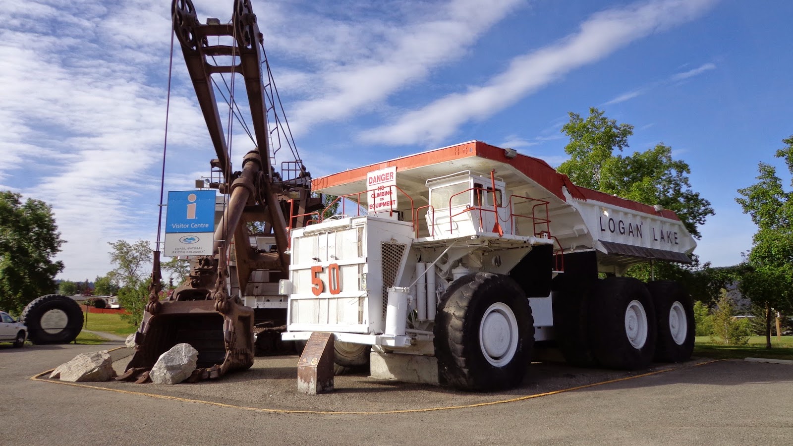
By far the biggest reference point in Logan Lake is the giant mine shovel and it's neighbouring terrain moving mine truck. Both of these "small" units are now retired and serve as the local tourist centre. Many a city folk, (me included), have parked their geomobile next to the truck and snapped a picture to compare the "hugeness" of these mine machines to our tiny on-road vehicles. As it was, this was also the site of our first cache, which was doubly convenient as this was also the site of the community centre where the automotive swap meet (remember me mentioning that) was taking place and the whole genesis of the idea of the road trip!
As the idea of an automotive swap meet bores me to death, I took the opportunity to wander around the show and shine to snap a few pictures of the trucks. Yes trucks...as I am a "Jeep guy" first, followed a close second by being a "truck guy", I was more interested in the old trucks turned out in their Sunday best.
Here's a picture expressly for my "corn binder" loving friend Fred whom has had his old IH sitting in his driveway for longer than my kids have been around (and they are married now) swearing one day he'll get it back on the road! :)
After wandering around the show and shine, I went back to the geomobile and had a nice snooze in the sunshine...ahh, life is good sometimes...
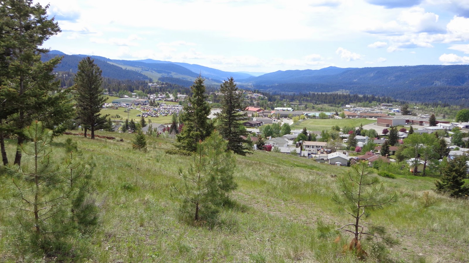
Eventually we started caching again, picking up some of the in-town caches in small parks and a couple of Gold Country caches like the one above called "Birth Place Of Logan Lake". This one provided a good viewpoint of the city and the valley below the hill
.
Here's a good delegation of chores....MrTJ points out the cache to Bowser98, Bowser98 digs the cache out and signs the log, and tjguy98 (me) snaps a picture for posterity.
After Logan Lake, we cached all the way back to Merritt, where we popped into town for a late lunch that we knew would have to hold us over until late at night. We were going to head home to Vancouver today via Spences Bridge and we knew once we got on the road we probably wouldn't be back in Hope until 8.00 or 9.00 PM at the earliest.
The road to Spences Bridge is filled with history, from local First Nations to early European pioneers.who farmed the land, and were eventually buried in that same land.It was a hard life, only a generation or two back from us, but it was a whole different world.
And through it all, the life lines of the day ran non-stop taking produce to markets in the near cities and as far away as Vancouver, transported needed goods to your homestead, and took you away.to places so far away they seemed like travelling around the world. The railway...or railways, as there were many independently owned ones at the time, cut straight lines through the towns and valleys as they worked their magic on our fore fathers. Above is an old railway bridge over the Nicola River, still standing 100 years later.
As we got closer to Spences Bridge it starting getting hotter, like the heat you feel in Lytton in the middle of summer. We had crossed into another geo bioclimatic zone, of which there are 14 in BC, and the heat had us driving with the windows down even at highway speeds. Hoodoos appeared along the Nicola River and with the sun on the decline the walls of the cliffs were bathed in golden light...absolutely the perfect light to show off the sandstone's natural colours.
If you haven't already, click on the above pictures to see them full size and see the natural erosion of the cliffs.
We crossed the Nicola River one last time knowing that just a few miles down the road was Spences Bridge and our last caching stop of the day. We picked up a few new caches that had appeared since our last visit to town, then high tailed it down the Thompson canyon to Lytton, where the Thompson River merged with the Fraser River, and then followed the Fraser River as it ran through picturesque Fraser Canyon all the way to Hope.
A quick stop at the local Timmy Ho's for a bowl of chili and a coffee provided energy for the 90 minute drive back into town. MrTJ and Bowser98 dropped me off at my door at 10.30 PM, and then headed home themselves.
It was a whirlwind two day tour were we combined sight seeing, a swap meet, and geocaching into one big fun trip. We found around 100 geocaches, which isn't a world record by any means, but it was plenty for us as the geocaches took us to beautiful places, all the while teaching us some history about Super Natural BC.
After 18 years of service my 1998 Jeep has taken a rest. In its place is a 2016 Ford Edge. My love of exploring has not changed, and at the root of all my travels is the love of finding something new. It's on these pages I've written travel logs to describe my wanderings. I hope you enjoy the stories ...
Showing posts with label Spences Bridge. Show all posts
Tuesday, June 10, 2014
Wednesday, September 28, 2011
The Jeep Brothers Go On A Road Trip - Day One
"Summer time.....and the living is easy....." so goes the song.....a time when all is mellow and right in your world, at least for a few moments. But those moments live on fondly in your memories for years to come.
Such was a few moments in my life when my brothers Alan and Ken, AKA Bowser98 and MrTJ, decided that it was time to pack up just the three of us into one of the trucks and spend a few days doing a caching run up to the Interior of BC. We had done a similar trip a couple of years ago, and I for one couldn't wait to do another.
I have a Jeep TJ, Alan has a Jeep Liberty, and up until recently MrTJ also had a TJ, hence the moniker of "The Jeep Brothers" that some of our caching friends have bestowed on us. Well, I guess I've been called a lot worse!
So here was the plan; start the serious caching in Hope, cruise up the Fraser Canyon and finish off the day in Cache Creek. From there we would head over to Kamloops for the night, then on to Salmon Arm for the last night, and head back home from there. Well, we did pretty well just that, with lots of caching in between.
Now here's the problem....MrTJ and myself travel and cache quite a bit, so I've done lots of the ones up the Fraser Canyon. MrTJ and Bowser98 have done a bunch of the ones in Hope from a previous trip to the Interior, so now matter how we sliced it there was going to be some repetition of cache visits for one of us. Oh well, just do it and soon enough we'll be on to virgin territory.
We did most of the caches around town and the ones we liked the most were the ones along the old Kettle Valley Railroad right of way in the Suckers Creek area, a small marshland that lies between Kawkawa Lake and the Coquihalla River. The rail right of way is a smooth slightly graded walk about a kilometre long, which gave us plenty of time to chat in between spaced out caches. The history of the area was a big pull for us, to be able to walk in the footsteps of our heritage is always neat.

We especially liked the cache that was located at the heritage 1861 Anglican Christ Church; this gothic revival design building was built at the height of the gold rush in the area by the Sappers, as the British Royal Engineers were known. Besides administering to the hordes that came this way, it was also a strong reminder of the British presences in the area.
After grabbing lunch at one of the fine eateries in town, we began our northen journey up the Fraser Canyon. A couple of caches close to each other gave us a bit of a charge, each in their own way. The first was at the intersection of the highway and Nickel Mine Road. The cache was located just outside a private residence, one with an acre or two of wooded property; the cool part was the owner had salvaged many articles from the abandoned mine up the road for his house. Items like old bed frames, miner's picks and axes, mine helmets, lanterns and even a couple of old tractors gave the yard a great nostalgic feel...we would have loved to wander around his yard.
The other cache we liked was back across the highway and down at the edge of the Fraser River. One of the old time residents had left his property to the government, and the parks board has granted public access down to the rivers edge. I have to admit, this was a bit of a different view of the river for me; for most of the Canyon's length, travellers are high above the river looking down at it. At this new park we could walk down to a small sandy beach area and be at river's level. Oh yeah, there was a cache there too!
We headed on up to Emory Creek Provincial Park, where a campground was located on an old miner's camp. In 1858 the area was one of tents and miner shacks; When the gold just wasn't present in numbers they thought, many miners moved north up the Canyon looking for better pickings. After changing hands a few times, the CPR decided to make Emory City as the western terminus of the railroad; with this proclamation the town grew swiftly, counting thirteen streets, it's own newspaper, various shops, a brewery, nine saloons and a sawmill. When Yale was made the terminus instead of Emory City, the town died; just a few short years later by 1885, the town was all but abandoned.
I have to say, of the two caches we were looking for here we failed miserably! We couldn't even get close to one in the park above the camping area, and the other one by the river we thought must be missing. No one else has found it since, so we're sticking to that story. While thrashing around in the bush, on top of the hill above the river, MrTJ made a neat discovery; two wide rows of boulder size rocks neatly stacked up, the rows being approx 80 feet long each and about 4 feet high.
My first thought was we had wandered into one of the Native Indian fortification areas along the river used to repel raiding parties of other First Nations groups. Upon looking at the lay of the land, and realizing that these stacks ran perpendicular to the river, not parallel, I realized these were probably remnants of placer mining done by the Chinese miners; I've seen stacks like this in other areas, such as in Lillooet not far from where the Hanging Tree is located. For me, this was major cool - stumbling into a piece of hidden history was a great surprise!
We continued northward, stopping only occasionally to do a cache as MrTJ and I had already done all the caches in the Canyon, so we stopped for the benefit of Bowser98 to find the odd cache. In Boston Bar we stopped in town at a cache called "Cache, Cables, and Cars"; this one was a micro cache located on one of the old aerial trams that used to transport cars and people across the Fraser River from the Boston bar side to the North Bend side. Not so long ago the tram was still in use, until they finally built a bridge across the river.
We got into Lytton and started doing a few more caches, especially the Gold Rush caches put out by some of the small towns in the Gold Rush area. These caches are found in a geo-tourist book, each page giving a full historical recount of the area where the cache is located; collect 24 stickers from the caches and you can send away for a geocoin in the shape of a gold bar.
We hit the cemetery caches and showed Bowser98 around the small town, stopping for the always great view of where the blue water of the Thompson River meets with the muddy brown of the Fraser River. The Thompson water resists merging for a few hundred yards, but can't resist the influx of the mud bearing Fraser for long.
Off we went, the next neat stop being Nicomen Falls - if you haven't seen these falls before, they are spectacular. This 272 foot two step waterfall plunges out of an extremely narrow basalt gorge into a 400 foot amphitheatre gorge. The water flow is not great, but it is enough to have carved a sinuous, twisting slot through the basaltic rock formation, making the falls appear to spring from a cave in the middle of the rock wall. The best picture I have ever seen is from high above the fall's level; there you can actually see further back into the gorge from whence the waterfall springs.
We mosied on further up the highway; at Lytton we had left the Fraser Canyon and were now following the Thompson River as it travelled through the Thompson Canyon. In places the road was down almost at river level; here the road was carved out of the side of the cliff were normally the river would roar through at the height of the spring freshet. It is quite a sight to see, and can be slightly unnerving to see the wide raging river almost even with your car!
Spences Bridge brought us to a small community on the banks of the Thompson River before it heads south into the canyon. Here the river was slower, and prime steelhead fishing grounds. We stopped at a cache in a small rec type camping area that I'm sure exists solely for fishermen to camp and fish the river for steelhead. While here, Bowser98 noticed an old truck in the campsite that had been refurbished and was being used to haul a trailer. Bowser98 meandered over to have a conversation with them about the truck and to grab a couple of pictures for his Flickr albums; check out BC Road Relics for photos of old working trucks.
Anyways, after a few minutes of chatting turns out the owner is a fellow geocacher named tedylok; we've been chasing him up the canyon all day! We had a good conversation about geocaching and old trucks and life in general before we realized that, with night fall it wasn't getting any brighter, and we still had a bunch of miles to put under our caching belts before we made it to Cache Creek.
We found a few more caches in Spences Bridge in the dark, then started spinning the wheels on the F150 to get on our way to our final stop of the night. It was a shame really, as there are quite a few neat places to cache along this route but the night time made the locations "ordinary" and there were just too many caches still to do before we touched down for the night.
We bypassed the turnoff for Ashcroft and all it's caches, we would get to them in the morning. We headed on up the road a few more miles till we pulled into Cache Creek and picked off a few caches in the dark around town. Finally, around 10.00 PM, after being on the road and caching for 14 hours, we decided to call it quits for the night. We grabbed a really late dinner at the 24 hour A&W in town, then went in search of a hotel room where we could crash for the night.
Whew! Lots of story telling and it's only day one!! Man, I sure can spin a yarn! LOL
All pictures from the trip can be seen on my Flickr page here TIP - right click on link to open new web page
Such was a few moments in my life when my brothers Alan and Ken, AKA Bowser98 and MrTJ, decided that it was time to pack up just the three of us into one of the trucks and spend a few days doing a caching run up to the Interior of BC. We had done a similar trip a couple of years ago, and I for one couldn't wait to do another.
I have a Jeep TJ, Alan has a Jeep Liberty, and up until recently MrTJ also had a TJ, hence the moniker of "The Jeep Brothers" that some of our caching friends have bestowed on us. Well, I guess I've been called a lot worse!
So here was the plan; start the serious caching in Hope, cruise up the Fraser Canyon and finish off the day in Cache Creek. From there we would head over to Kamloops for the night, then on to Salmon Arm for the last night, and head back home from there. Well, we did pretty well just that, with lots of caching in between.
Now here's the problem....MrTJ and myself travel and cache quite a bit, so I've done lots of the ones up the Fraser Canyon. MrTJ and Bowser98 have done a bunch of the ones in Hope from a previous trip to the Interior, so now matter how we sliced it there was going to be some repetition of cache visits for one of us. Oh well, just do it and soon enough we'll be on to virgin territory.
We did most of the caches around town and the ones we liked the most were the ones along the old Kettle Valley Railroad right of way in the Suckers Creek area, a small marshland that lies between Kawkawa Lake and the Coquihalla River. The rail right of way is a smooth slightly graded walk about a kilometre long, which gave us plenty of time to chat in between spaced out caches. The history of the area was a big pull for us, to be able to walk in the footsteps of our heritage is always neat.

We especially liked the cache that was located at the heritage 1861 Anglican Christ Church; this gothic revival design building was built at the height of the gold rush in the area by the Sappers, as the British Royal Engineers were known. Besides administering to the hordes that came this way, it was also a strong reminder of the British presences in the area.
After grabbing lunch at one of the fine eateries in town, we began our northen journey up the Fraser Canyon. A couple of caches close to each other gave us a bit of a charge, each in their own way. The first was at the intersection of the highway and Nickel Mine Road. The cache was located just outside a private residence, one with an acre or two of wooded property; the cool part was the owner had salvaged many articles from the abandoned mine up the road for his house. Items like old bed frames, miner's picks and axes, mine helmets, lanterns and even a couple of old tractors gave the yard a great nostalgic feel...we would have loved to wander around his yard.
The other cache we liked was back across the highway and down at the edge of the Fraser River. One of the old time residents had left his property to the government, and the parks board has granted public access down to the rivers edge. I have to admit, this was a bit of a different view of the river for me; for most of the Canyon's length, travellers are high above the river looking down at it. At this new park we could walk down to a small sandy beach area and be at river's level. Oh yeah, there was a cache there too!
We headed on up to Emory Creek Provincial Park, where a campground was located on an old miner's camp. In 1858 the area was one of tents and miner shacks; When the gold just wasn't present in numbers they thought, many miners moved north up the Canyon looking for better pickings. After changing hands a few times, the CPR decided to make Emory City as the western terminus of the railroad; with this proclamation the town grew swiftly, counting thirteen streets, it's own newspaper, various shops, a brewery, nine saloons and a sawmill. When Yale was made the terminus instead of Emory City, the town died; just a few short years later by 1885, the town was all but abandoned.
I have to say, of the two caches we were looking for here we failed miserably! We couldn't even get close to one in the park above the camping area, and the other one by the river we thought must be missing. No one else has found it since, so we're sticking to that story. While thrashing around in the bush, on top of the hill above the river, MrTJ made a neat discovery; two wide rows of boulder size rocks neatly stacked up, the rows being approx 80 feet long each and about 4 feet high.
My first thought was we had wandered into one of the Native Indian fortification areas along the river used to repel raiding parties of other First Nations groups. Upon looking at the lay of the land, and realizing that these stacks ran perpendicular to the river, not parallel, I realized these were probably remnants of placer mining done by the Chinese miners; I've seen stacks like this in other areas, such as in Lillooet not far from where the Hanging Tree is located. For me, this was major cool - stumbling into a piece of hidden history was a great surprise!
We continued northward, stopping only occasionally to do a cache as MrTJ and I had already done all the caches in the Canyon, so we stopped for the benefit of Bowser98 to find the odd cache. In Boston Bar we stopped in town at a cache called "Cache, Cables, and Cars"; this one was a micro cache located on one of the old aerial trams that used to transport cars and people across the Fraser River from the Boston bar side to the North Bend side. Not so long ago the tram was still in use, until they finally built a bridge across the river.
We got into Lytton and started doing a few more caches, especially the Gold Rush caches put out by some of the small towns in the Gold Rush area. These caches are found in a geo-tourist book, each page giving a full historical recount of the area where the cache is located; collect 24 stickers from the caches and you can send away for a geocoin in the shape of a gold bar.
We hit the cemetery caches and showed Bowser98 around the small town, stopping for the always great view of where the blue water of the Thompson River meets with the muddy brown of the Fraser River. The Thompson water resists merging for a few hundred yards, but can't resist the influx of the mud bearing Fraser for long.
Off we went, the next neat stop being Nicomen Falls - if you haven't seen these falls before, they are spectacular. This 272 foot two step waterfall plunges out of an extremely narrow basalt gorge into a 400 foot amphitheatre gorge. The water flow is not great, but it is enough to have carved a sinuous, twisting slot through the basaltic rock formation, making the falls appear to spring from a cave in the middle of the rock wall. The best picture I have ever seen is from high above the fall's level; there you can actually see further back into the gorge from whence the waterfall springs.
We mosied on further up the highway; at Lytton we had left the Fraser Canyon and were now following the Thompson River as it travelled through the Thompson Canyon. In places the road was down almost at river level; here the road was carved out of the side of the cliff were normally the river would roar through at the height of the spring freshet. It is quite a sight to see, and can be slightly unnerving to see the wide raging river almost even with your car!
Spences Bridge brought us to a small community on the banks of the Thompson River before it heads south into the canyon. Here the river was slower, and prime steelhead fishing grounds. We stopped at a cache in a small rec type camping area that I'm sure exists solely for fishermen to camp and fish the river for steelhead. While here, Bowser98 noticed an old truck in the campsite that had been refurbished and was being used to haul a trailer. Bowser98 meandered over to have a conversation with them about the truck and to grab a couple of pictures for his Flickr albums; check out BC Road Relics for photos of old working trucks.
Anyways, after a few minutes of chatting turns out the owner is a fellow geocacher named tedylok; we've been chasing him up the canyon all day! We had a good conversation about geocaching and old trucks and life in general before we realized that, with night fall it wasn't getting any brighter, and we still had a bunch of miles to put under our caching belts before we made it to Cache Creek.
We found a few more caches in Spences Bridge in the dark, then started spinning the wheels on the F150 to get on our way to our final stop of the night. It was a shame really, as there are quite a few neat places to cache along this route but the night time made the locations "ordinary" and there were just too many caches still to do before we touched down for the night.
We bypassed the turnoff for Ashcroft and all it's caches, we would get to them in the morning. We headed on up the road a few more miles till we pulled into Cache Creek and picked off a few caches in the dark around town. Finally, around 10.00 PM, after being on the road and caching for 14 hours, we decided to call it quits for the night. We grabbed a really late dinner at the 24 hour A&W in town, then went in search of a hotel room where we could crash for the night.
Whew! Lots of story telling and it's only day one!! Man, I sure can spin a yarn! LOL
All pictures from the trip can be seen on my Flickr page here TIP - right click on link to open new web page
Tuesday, July 21, 2009
Crazy Canyon Caching
ABOVE: Somewhere on the Thompson RiverCrazy Canyon Caching is an excellent name for this trip report as the whole day fits into the category - just crazy!
Here's the stats on the day; 22 hours on the road, 770K, 12 Gold Country Caches for Cookie Cacher, 12 more for me to obtain my 24 caches required for the Gold coin, a total of 60 caches for me and 66 for Cookie Cacher!
Videos and the GPS route of the day's trip, uploaded to EveryTrails.com, can be found at the end of the write up.
THE STORY
I had been up the Fraser Canyon two weeks ago with Stu, AKA Scruffster, as we blasted our way through the canyon one early morning on our way to Cache Creek to arrive just in time for the official late morning kick off of the Gold Country Geotourism event. The event was being held in 6 cities, Cache Creek, Clinton, Lillooet, Lytton, Merritt and Logan Lake, all in an effort to promote tourism in the area.
All that morning, we kept on passing caches that just begged us to pull over and find them; with broken hearts we passed them by, knowing full well we would be back here soon answering their call. This Saturday we were back, only instead of Scruffster being in the shotgun seat, it was Jeanine AKA Cookie Cacher.
Cookie Cacher had been asking to go caching with me for quite a while, and today seemed like the right time for me to make good on my promise of a day of caching together.
We met up in Maple Ridge at 6.00 AM, me almost sleeping in and waking up only 20 minutes before we had to meet. We met up, both of us semi-awake, loaded Jeanine's stuff into the Jeep, and cruised east out of Maple Ridge aiming for the Fraser Canyon.
We did a couple of caches just north of Hope as a way of warming up on the day, then made our way to Emory Creek area where 4 caches awaited us.
One of the caches highlighted the Emory Creek area, explaining how there was a townsite here in the 1880s; it boasted of 13 streets, two hotels, nine saloons, a brewery, blacksmiths, a general store, and residences. It soon became evident that the CPR would make Yale the terminus of the railroad, and by the 1890s no sign was to be found of Emory City.
Also in the area is a Provincial historic signpost explaining the significant contribution of the Chinese in building the original Cariboo Road, and later the railroads.
We found the 4 caches in the area, then moved on to Yale to look for caches there.
In Yale there are several historic places, suchs as the oldest church in BC still on it's original foundation, Lady Franklin Rock, named after Lady Franklin who toured the world while her husband was on his expedition to the Artic.
Another little know fact is that, in 1868 there was a meeting of 26 delegates from all over the colony of BC who were dissatisfied with the colonial government. This convention did much to stimulate popular support for the idea of the Colony of BC uniting with Canada to become a province of Canada.
We finished up in the Yale area, then moved north on our journey, grabbing various roadside caches that highlighted the best scenic viewpoints in the Fraser Canyon, or otherwise little mentioned historic areas.
Another of the more historic spots was highlighted with a cache placed on a trail; not just any trail, but an HBC Fur Brigade Trail.
This one was placed a short ways up the trail next to Alexandra House. Alexandra House was a road house on the original Cariboo Wagon Road, and the fur brigade trail predates the road house. The original road house was torn down and the current one built, supposedly using one or two of the original road house walls. Hard to determine which ones were used, but even so, the current building is pretty old as is.
The cache was located about a 5 minute walk up the trail from the noisy canyon road, but you might has well been 100 miles from anywhere. The trail leads over the mountains into the Coquihalla Valley, on through the Voight Valley, then cuts across the Douglas Lake Ranch holdings on it's way to Fort Kamloops.
In it's heyday, the pack trains of horses were an incredible site; 500 horses packed with large 80 pound bales of fur on each side, requiring 150 men to run the pack. The First Nations people would watch this procession go by in amazement; never had they seen so many "English" men at one time.
In the Gold Rush days, there were two kinds of white man; those that came from America were called "Boston men", as many of the gold seekers came from Boston. Every one else was called an "English men", as most of the non-Americans were English.
This was a great chance to stretch our legs and provided the wonderful experience of allowing us to step back in time, if just for a few minutes, and imagine the sound of many hooves from labouring horses, intermingled with the voices of the packers encouraging their charges to keep moving.
Northward we continued, stopping at more viewpoints and scenic waterfalls till we got to Boston Bar, the site of a bar in the river first worked by American miners, hence the name "Boston Bar". Here we did a couple of caches aimed at highlighting the old suspended cable car that use to run over the Fraser River from Boston Bar on the east side, to North Bend on the west side.
Many an old folks have used this cable car, and can still vividly recall their trips. Years ago the cable car was replaced with a high level bridge to provide more permanent and improved access for the residents on the west side of the river.
In Lytton we came across our first Gold Country caches, where we started collecting stickers to place in our books. We visited a historic church, The Church of St. Mary and St. Paul, and the Lytton cemetery; we also stopped at the Lytton Jelly Roll, so called because, well...it looks like a giant jelly roll. The roll was created in an ice bound lake during the last glaciation period when an underwater landslide caused the sediment layers to slump away. Rather than breaking up and dispersing, the layers rolled up instead to look like a jelly roll.
With jelly rolls on our minds, we scoured Lytton for as many more caches as time would allow, before we headed north once again.
Next stop, beautiful Nicomen Falls; get ready for a great view of a tall waterfall seemingly coming out of a crack in the hill, and a steep short hike to find the cache. This one I looked forward to doing, and I didn't.....I'm no so good on uphills... :(
But, there was no way I was going to pass on this cache just because I had to huff and puff a little bit; besides, I was hedging my bets......I had Cookie Cacher along to perform CPR in case I over exerted myself... :)
As it was, a short, 2 minute hike brought us to the cache location...."well, that was easy"!
"What was I whining about"? With cache in hand and cameras going, we took a few minutes to enjoy the area, before the calls of the caches up the road begged us to continue.
Into Spences Bridge we went, criss crossing the small town while we searched for caches at a cemetery, at the oldest Inn in BC, at a small camp ground on the banks of the Thompson River, and at a small cafe called The Packing House.
Caches found, it was time for a "time check"; it was 5.30 PM-ish.....oh boy, so many more caches to do, so much more ground to cover.
We raced towards Ashcroft picking off caches as we went, taking the time at each cache to enjoy the scenery. As much as we wanted to to the "dash and grab" thing, the vistas where just so beautiful we couldn't help but stop to admire the land and think of what it was like over 100 years ago. It might not be all that different now; the clear blue Thompson River cutting it's way through the surrounding lowlands of glacial till, vast morraines of gravel and sand left by the retreating glaciers 10,000 years ago. The low rainfall, hot sun, and poor soil combine to make this the land of sage brush and rattlesnakes.
We arrived in Ashcroft around 7.30 PM, knowing that we had two, maybe three hours of daylight left before we would have to make a decision; whether to quit at night fall, or break out the flash lights.
We did the Ashcroft caches as quick as we could, then moved up to Cache Creek to pick up the ones there. By now it was around 8.30 PM....what to do, what to do.....we still had a few more caches to do, and I was getting caught up in the Gold Country quest as I only needed 4 more caches to get my 24.
We made the daring decision to push through to Clinton to pick off the caches we could, specifically the Gold Country caches. It was after 9.00 PM by the time we got into Clinton, and we needed to break out the mini mag lights to find the caches around town, all the while trying to not be too suspicious waving flashlights around in a small town.
We grabbed the Gold Country cache at the historic St Peter The Apostle church by the light of the flash lights and got away from the church lest we looked like we were up to no good.
Back in the Jeep, we counted the Gold Country caches, I now had 23, I needed one more! ARRRGGHH.......
Oh well, by now it was after 10.00 PM and it was time to start heading south for the long drive.
Visions of completing my Gold Country quest were fading as I realized it was not to be this day, and that I would just have to do another tour to the area.
Heading back to Cache Creek, Cookie Cacher says to me, "you know, there is another Gold Country cache called Hat Creek just 26K west of Cache Creek on Hwy #99"
I ran the logistics through my head, guesstimating how long it would take to drive out west, find the cache, drive back, and then dead head all the way back to Vancouver. I came to the conclusion that it was better to say "enough's enough", and head home.
Cookie Cacher gave me one more assurance that if I wanted to go grab the cache, she was willing......tempting, but nahhh....time to turn towards home.
As we approached the turn off for Hwy #99, I was content to know that one more cache was waiting for me some where down that highway.
"Wait, what's this".....that adrenaline rush was starting in the brain and moving down my arms, and then into my hands....and then a 'force' over came me and I turned the wheel hard so that the Jeep's grill was now pointed west ward towards the last remaining cache.
I couldn't see Cookie Cacher in the darkened cab of the Jeep, but I swear she was smiling, knowing that I had felt the irrestible pull of "just one more cache"!
Down the highway we ran, highbeams picking up the curves of the road as it meandered through what I remember is a lovely small valley with farm houses filling in the loneliness of the land.
We arrived at a fork in the road, one sign saying Hat Creek Road....Cookie Cacher says "thaddaway 4K"....off we go on the gravel road, the Jeep's tires hugging the gravel around the corners keeping us safe. We come to one more fork in the road, Cookie Cacher says "Left" on Upper Hat Road, just one more K and then "STOP"!
We park the Jeep on the side of the road, leave the parking lights on to help us find our way back in the dark, break out the BFLs and plunge off into the bush counting down to the treasure 30 metres away. We end up going in circles for a few minutes before Cookie Cacher leads us to a suspicious looking wood pile; we grab the wood off the pile and YES, YES, YES!! there it is!!
Number 24 of the Gold Country caches found, the day is now complete!
We sign the log, ensuring we grab the required stickers, I do a little bit of the "Oh Yeah, Oh Yeah" dance singing "uh huh, uh huh, oh yeah, oh yeah, complete with the arms and hip movements! Cookie Cacher is not impressed....actually I think she was trying hard not to laugh at me......
Back in the Jeep, back down Upper Hat Creek Road , then down Hat Creek Road as Cookie Cacher reads about the coal deposits found in the area, back down Hwy #99 to the turn off for Cache Creek, then into Cache Creek for a tank full of gas for the Jeep, and a stomach full of Momma and Sirloin Burgers for us.
We looked back on the day, thinking how 6.00 AM was so long ago, it seemed like yesterday, and it almost was. Stomachs full, we started back through town when I said to Cookie Cacher, "wait, there's one right there you can get".
So, here we are, in downtown Cache Creek, in the middle of the busiest intersection in town, right by the Dairy Queen, at midnight, finding our last cache.
OK, OK, that's really enough now!! Let's put away the GPS' and start home.
And we did, back down along the Thompson River, through Spences Bridge, through the Thompson River Canyon, entering back into familiar territory when we once again joined the Fraser River at Lytton.
Down on through the Fraser Canyon we travelled, past caches that we found oh so long ago....
We spit out of the Canyon at Hope, now on flat land, and hightailed it back to where Cookie Cacher had left her car in Maple Ridge.
It was just before 3.30 AM that I dropped her off, I'm sure she didn't get home till after 4.00 AM. 22 hours on the road, a whole day come and gone in the search for little tupper ware containers in the bush...some how it all seems so normal to me! :)
It took me hours to go through and log the caches, and I'm sure it was the same for Jeanine, not to mention the pictures to download.
Still, if you asked me to go up country this weekend and do it again, I'd say sure! That is, if I'm allowed.... LOL
Videos below, as well as the GPS Route I made of the day and uploaded to EveryTrails.com
You can click on the map to go to EveryTrail.com and see more details. You can also change the map type be selecting a different map style from the drop down menu in the upper right.
Fraser Canyon Caching at EveryTrail
Map created by EveryTrail: Geotagging Community
Labels:
Ashcroft,
Boston Bar,
Cache Creek,
caching,
Clinton,
Fraser Canyon,
Fraser River,
geocaching,
Gold Country,
Spences Bridge,
TJGUY98
Subscribe to:
Posts (Atom)


