Showing posts with label geocaching in BC. Show all posts

Thursday, August 01, 2024

 Cruising into the Columbia Valley


ALL PICTURES ON THE DAY CAN BE FOUND ON MY FLICKR WEB SITE HERE

YOU CAN ALSO CLICK ON THE PICTURES YOU SEE ON THIS PAGE TO HAVE THEM OPEN FULL SIZE

Recently Brother Ken, aka MrTJ in geocaching circles, and myself decided to make a foray into a forgotten corner of the Fraser Valley, someplace where neither of us have visited for 50+ years.

Cultis Lake, 60 miles east of Vancouver, B.C. is Vancouver's local favourite summer time destination. Cultis Lake is a fair size lake surrounded by long time summer cottages on the east, new lake front houses on the north, and densified during the summer by multiple campsites both in Cultis Lake Provincial Park and private campsites along the south shore. At the west end of the lake is the small village of Lindell Beach, an old clutch of summer cabins turned mixture of permanent residences and long time family cottages.

Beyond Lindell Beach, west along Columbia Valley Road, lays a large valley mostly forgotten about by the summer visitors. The craziness of the boaters, paddlers, swimmers, campers, and the occasional obligatory moron, is quickly left behind in just a few minutes as Columbia Valley Road ascends a small bluff and emerges into the Columbia Valley. Due to glacial action thousands of years ago, the Valley is officially classified as a "hanging valley."

The first impression you receive is that you could be in any rural green valley near Salmon Arm, or anywhere in the central part of Vancouver Island. The look of the valley belies its nearness to Canada's third largest city. 

Ken and I barely remember the valley from those many years ago, safe to say neither of us remembered it as we seen it this day. There were a few newer hobby farms with big new houses, but for the most part it seems like the farms and houses we seen years before are the same ones we seen today.

We had approx. 30 caches to find in the valley, with a bit of crossing our tracks back and forth due to the limited number of roads and the spread out nature of the cache placements.

Although I had made an adhoc route for the day, as usual that changed a bit once we got our feet on the ground. We came to realize there was a north side to the valley, a central part, a south side, and then two east sides divided by a ravine watershed. Once we understood the road layouts and the cache placements, the order to find the caches in changed and in turn, made our stops more orderly.

We started our route grabbing the caches along the north side as it was the more straight forward section. We then crossed the valley and started on the south side caches. I had looked at the maps and noticed that the south road ran close to the border. We were very surprised when we arrived on a straight section of road and noticed the forest cut line on the hills nearby. Knowing the cutline ran along the 49th Parallel delineating the International border, we eyeballed the path of the cutline running on the hills in front of us and behind us, and realized we must be very close to the border. We were even more surprised when we realized that the we conveniently stopped next to an obelisk used as the Canada-US border marker. This marker was two feet off the roadway, meaning we were _right on_ the US border. 

We took pictures of both sides of the obelisk; one side says Canada and the other side says United States. Technically I stepped into the US when I went to the other side of the obelisk but all worked out - no floodlights, barking dogs, or armed guards appeared out of the woods to challenge me, so I figured I was good! 

We soon made our way to the eastern side of the valley, and were slightly mystified as to how to get to caches on the other side of a ravine\creek, until we determined we had to go back to the main road, and then tackle the next set of caches from a more eastern access.

Ken and I were surprised by how many blueberry farms are now in Columbia Valley. The Maple Ridge and Pitt Meadows areas with their wetter fields are well known for their vast blueberry fields. The ground here was harder and dryer, although we did notice their seemed to be a lot of sand in the soil. Perhaps the good drainage was an optimum growing environment for the bushes.

One of the caches to find was on a long a right of way road into the very ravine which caused our initial confusion. Ken recalled that he had a book on the old railways of the Columbia Valley and that this ravine access road was one of the main spurs for the railway back at the turn of the century when the valley was logged. Matter of fact, Ken mentioned that, due to the steep bluff from Cultis Lake up into Columbia Valley, the trains could not get down or up the bluff, so the main line went south into the US and the logs were distributed at Maple Falls in Washington state. 

Ken and I did our good deeds for the day for our fellow geocachers whom had hid the caches. As this group of caches were far off the beaten path, I came prepared with a trunkful of trinkets to refill the caches. I even had a dozen or so new cache containers of various sizes and I in turn replaced probably half a dozen missing caches. I also cleaned up, dried out, and replaced paper to use as cache logs for the benefit of cache finders to follow. Looking at past logs, many of these caches had not been found for 6 months. Safe to say these caches were the "way out there" finds to make and did not generate much geocaching traffic during their existence.


Ken and I thought our day might have ended early; you know, get out on the path by 10.00 AM, not find some missing caches, get frustrated and over heated due to the hot weather, quit, go for lunch and then go home! LOL

Instead, any cache we could not find we replaced, any cache found in bad shape was fixed up to be serviceable for months to come. Ken and I spent the entire day in this beautiful corner of the larger Fraser Valley area and thoroughly enjoyed our day. I was going to make a joke about the "company being dubious" 😀 but the fact is the siblings in the family get along great and we all appreciate the quality family time we spend together. But there is something special about hanging one on one for the day and remembering that the kindness and strength of your family is why your life is as good as it is !  

 Please leave a comment if you liked the trip report. I hope to create more in the next while. 


Friday, September 06, 2019

Story Of A Trip About "Vs' And "Ks" and One "M"


Click on any of the pictures to make them full size for your viewing enjoyment!

Once again I had the dubious pleasure of going on a geocaching road trip with two of my brothers where we spend an extended weekend touring cities and geocaching and acting like teenagers rather than grown men. It was a blast !

Brother Al and Brother Ken and myself headed to the Interior of BC looking to visit Al's son in Kelowna and another of our brothers and his wife in Vernon.

The trip took us from Vancouver through the cities of Mission, Kelowna and Vernon. Hence the name of this episode called V's and Ks and one M

We cruised out through Mission BC where we spent some time looking for a few caches in the city. The big "M"  you see in the picture above is an art piece celebrating the town of Mission and its industrial heritage. We did a few easy city caches, just enough to start the weekend on a positive note with successful hunts.


After Mission we crossed over the mighty Fraser River and headed to the Upper Fraser Valley city of Chilliwack. Once in Chilliwack we crossed over to the north side of the river and took some scenic farm roads as we followed a geocache series that wound it's way east with the landscape alternating between fields of summer time corn almost ready for harvesting, and quiet enclaves where livestock grazed the fields.
The nice thing about taking the back roads is you see more scenery than if travelling the highways and you come across unexpected treasures.

In this case the small village of Rosedale provided a stellar surprise in the form of an antiques shop housed in an old garage. Outside scattered around the garage property were old trucks. I have to admit my brothers are more into old cars than I am, but even I was impressed with a couple of vintage trucks that are rare to find. And to have two of them on the same lot was even rarer.


A red Diamond T flatbed was prettied up and parked waiting for admirers to come along. Diamond T trucks were built as luxury trucks of the times, if you had one of these you had serious money.


The other pretty boy on display was a Federal truck. I have seen a lot of old Fords and Chevies and Dodges but not often you see a Federal parked nonchalantly among the other old trucks.

After finishing our caching around Chilliwack we stopped for a quick bite to eat in Hope, then hotfooted it to Merritt and beyond to make up for time spent.
The three brothers arrange a geocaching road trip 2 - 3 times a year. The downside to frequent caching and road tripping is you tend to have to go through the same towns to get outside of your normal range. As a result of this, we have done many of the caches on the main roads that run to and through those towns.

Just east of Merritt we pulled into a natural grasslands reserve and found two Gold Country caches. The Gold Country series were created by multiple towns in the Thompson area of BC getting together drum up tourist business for their dying towns. And they scored big.
Over 200 hundred geocaches stretching from Merritt to Lytton and Lilloeet and all the way north to Clinton ensure there is a steady stream of folks running around the towns and areas looking for hidden treasure. Those same people overnight in the small towns, buying meals, gas, groceries and filling motel rooms and campsites which is a tremendous boost to the local economy.


As we had crossed over the Coast Mountains we were now on the leeward dry side of the mountains and the coastal rain forests of the coast had been replaced with dry grasslands and rolling hills.This is prime cattle and horse land, and many ranchers enjoy a good life living the cowboy way.


After finding the Gold Country caches we were back in the truck and on our way to Kelowna. Al's son Chris was expecting us and as Chris was out caching himself we sent him a hail to let him know we were in town and where to meet us.
Chris met up with us a city cache at a local farmer's market where we collectively found a geocache hidden on an old tractor.
It was good to see Chris as Ken and I had not seen him for months, and dad Al was happy to see his son as well. Family grows and move apart from each other, so you treasure those moments when you can get back together, even for a little while.

We managed to sneak in a few caches before the sun went down, and at that point we decided dinner and a beer were high on our list of things to find next..


ABOVE = Al and Ken AKA Bowser98 and MrTJ

Saturday we were out caching in the sunshine again with Chris along as a local tour guide. We did some downtown caches, some neighbourhood caches, and few caches on the outskirts of the city that brought us up into the hills for a good view of Kelowna.

 
The houses in the picture have lovely views but are sitting atop a rock, so chances of having a backyard to play is is limited. But you have what you want and what you can pay for. I guess if you don't have kids you don't have to worry about them falling off the cliff in your back yard.

We spent the day puttering around Kelowna and as the afternoon wore on we started working our way north towards Vernon. We had a dinner engagement lined up with another brother and his wife, so we had to keep on the move and be conscious of the time, all the while trying to get "one more cache" squeezed into the drive.


The Okanagan area of BC is lined up in a north-south orientation which follows the path of a glacier more than 10,000 years ago.
From Osoyoos in the south, which is located right on the Canada - U.S. border, to Vernon in the north, the Okanagan Valley is one long valley blessed with perfect weather for harvesting wines and fruit.
The wide valley also presented generous views along our route as we traveled to Vernon.

We made it into Vernon just a few minutes late, but then we found out there were two hotels of the same name just blocks from each other. One has the proper name, the other one doesn't advertise that name and the signs on the hotel use some other name. After wasting some time going back and forth we finally guessed at the right hotel and found our brother Wayne and his wife Inga waiting for us. Wayne has been having a medically tough time the past few years, so the visit meant all that much more. We would have loved to continue the visit after dinner but the whole exercise of getting out of the house and going out for dinner was too much of a strain for Wayne's health so we said our goodbyes for the night.


Sunday morning brought the threat of rain for the day. We didn't mind that too much as Wayne and  Inga had told us in conversation the temperature for the past three weeks had been hovering in the 40C degree mark. Way too hot to geocache as the heat just saps the strength out of you, and a fun day of geocaching quickly turns into sunburn, heat stroke, and a visit to the Dairy Queen instead of geocaching.

We cached in the morning in and around Vernon, one of the fun and pleasant things we seen was the community book exchange in some of the neighbourhoods. The city, or neighbours even, build these small elevated boxes and the residents donate books they have read. Other residents will visit, bring their own books, and exchange them for books which are in the box. This sort of idea brings the community together and as a visitor it is gratifying to see a positive vibe in the community.

We stopped for lunch and made that the break away point from our geocaching in Vernon, as we now had to start heading back towards Vancouver and we had a lot more caches to find on the way home.  Chris, Al's son whom had driven back from Kelowna that morning, joined us for lunch. As we were chowing down on our fine cuisine as presented by the local fast food chain, the rain started coming down in buckets.
Just as well, as we had an hour and half drive ahead of us to the next series of caches a couple of hundred miles away, so let it rain all it want.
We said our goodbyes to Chris, jumped in the truck, turned on the windshield wipers, and began the trip southward towards the Coast


The rain was just letting up as we reached our first stop on the new route of caches. We were now back in the range grasslands not too far from Merritt, with an old barn on a farm the location of our first cache.

A narrow glacier carved valley studded with low lands and intermittent small lakes and ponds headed south from the small community of Aspen Grove to Princeton. Along this valley were a series of caches amounting to 18 or more that would provide a few more notches on the belt for cache finds, as well as provide an alternative route home rather than the standard fast speed highways.


Many of the caches we were to find were located at roadside pullouts either along side on of the multitude of lakes, or they were on rises in the land which provided unspoiled views of the narrow valley.
     

Make no mistake, we were back in Cowboy land and if you forgot that for a minute, signs for dude ranches and country crafts helped you remember. So did the cow patties when you stepped away from the main roads and ventured on the side roads past the cattle guards.


It's surprising on how much time is taken up looking for geocaches, even if you have picked the ones close to parking so you can turn them into "park and grabs".
Between the miles to travel to Princeton and finding the caches along the route, it was dinner time when we rolled into Princeton.
A quick tailgate dinner was on the menu as we had another 135 miles to go and a 90 minute drive to our last few caches.


Our last cache to find was in Sunshine Valley just east of Hope.While the area is becoming increasingly popular as a weekend cabin area or year round out of the way home, it's original purpose was much darker.
This was the site of one of the internment camps for Japanese citizens during World War II.
It was wrongly assumed that if you were of Japanese heritage, you would turn against your own country and betray them during the war. Many families were rounded up, stripped of their monies, homes, business, and sent inland away from the coast to live in cold cabins more befitting a war criminal or POW.

Kudos to the local heritage society for keeping the memory of this painful part of history alive and in plain view of travelers lest we forget our mistakes of the past.

By now it was 7.30 PM and we still had a two hour drive to get to my house were Al had left his truck. Al still had another hour drive home after that while Ken's trip was considerably shorter.
We arrived home in the dark, emptied our gear out of the truck, had a chat about the weekend and when we should go again, then it was time to head into the house and get ready to head back to work in the morning.

Three brothers got to spend a weekend together, got to visit an ailing brother, and visit a son/nephew all on the same trip. And no band aids and gauze were required like one of our previous trips. (That's on another travelog report)  😉
   

The complete set of pictures can be found here on my Flickr photo web site.

If you liked the story drop me a comment   

Thursday, January 31, 2019

Victoria Rambling - Another Geocaching Trip To Vancouver Island


Once more the three amigos, actually three brothers, caught one of the BC Ferries and floated across the Straight of Georgia to Vancouver Island to cache in the general Victoria BC region.
 Ken, Alan, and Ed (myself), known in the geocaching world as MrTJ, Bowser98, and TJGUY98, were on a boys-only long weekend of geocaching and just plain having fun.

Every year there is an automotive swap meet in the Saanich area and Ken and Alan are big on going to the event to meet up with old buddies and see if they can pick up a few old car manuals which they resell through their online business.
For myself the swap meet was a necessary evil to endure as part of the weekend trip
No, not really  LOL    It's only 2-3 hours out of the weekend and while those two are meandering around the piles of treasure I usually take the time to prep for the geocaching day ahead.

CLICK ON ANY PICTURE TO SEE THEM FULL SIZE !!

Each time we visit the Victoria region we pick a different area to geocache in, that way we don't trip over caches already found, and we get to see new sights and vistas on our travels.

This visit could almost be called "The Ocean Tour" as most of the caches we picked were along the shoreline or beaches of Georgia Straight. This presented us with continually changing ocean views and scenic vistas. The pictures I took are almost all great to look at and I had a hard time picking just a few for the Blog. All the other picture are on my Flickr page and deserve a view.


We started our adventure just as soon as we disembarked the ferry in Swartz Bay by heading to a small cove hosting a local marina and houses along the shoreline. Boats at moor in the bay were to be a common sight on this trip, as the protected bays provide perfect anchor for those weekend sailors whom love the boating life style.


Want a house on the water? How's this, close enough? Maybe too close huh .. ?
What a fantastic view these people have, but look at the size of the logs on the beach right in front of the house. Can you just imagine a winter storm's powerful waves throwing those logs up against your retaining wall all the while the waves are crashing over your upper deck? 


Yeah, their railing on the lower deck looks pretty bashed up to the point of almost not being there.And look at that tree root sitting ominously by the retaining wall ..  Yikes!


It was already late in the day as this was our "travel" day so we headed over to the small town of Sydney for an early dinner. This is a lovely little town and we always enjoy stopping in when ever we visit the Island. There is always a good place to have either a light meal or a full meal, depending on your appetite, and all at a fair price. Plus, a stop at the Sydney Bakery for dessert sure helps the attitude as well. 😋


Sydney has half a dozen bench/statues on the main drag and these are great conversation pieces and cool art works, plus having a place to sit down to eat your ice cream is always handy.
The local Legion has a jet fighter, an artillery gun, and a tank on display, so there is more yet to see for the visitors (Check my Flickr page for those pictures - link at the bottom of the page)


We always love doing the geocaches that highlight local historical locations and this was one of them. Back before the highways were built for commerce, the water was often the highway of choice. The farms of the area relied on the water to get much of their produce to market. We visited the former site of the Newman Farm which highlighted the importance the ocean shoreline played for them.


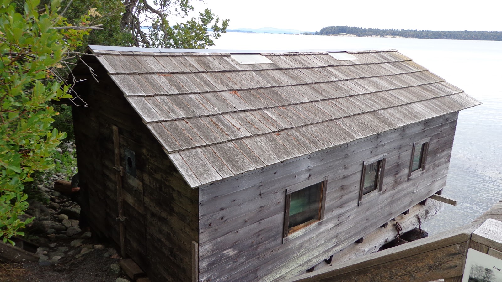
Straight from the fields you take the steps down to the water and find the farm's boathouses housing the farm transport of the time, the boats to take your goods to market.

DAY 2     

We headed down the Patricia Bay Highway south from our hotel and continued picking up caches along the shoreline.Some caches had us on bluffs overlooking the ocean, others had us down in the tidal zone in parks or nature reserves which preserved the ocean side habitat for fish, fauna, and flora alike.
One of the caches was located on a hillside in the middle of a small subdivision. We had to take 3 flights of stairs to get down to the landing where the cache was located. We passed a swarm of small flies on the way down the stairs and I was last in line so I could tell they were stirred up by the time we all went past. We found the cache, enjoyed the view, and then trudged back up the stairs back to the truck. As we past the flies again they were even more agitated and as I was last in line again they took their displeasure out on me. No biggies, they are just flies. OUCH, Jesus H Christ those aren't flies, they are small black wasps and they were given me the what-for! I got 4-5 stings before I could get far enough away from the nest before they left me alone. And of course those other two clowns thought that was all pretty funny! I would too if it was one of them 😎


Another historical cache we came across highlighted the history of the First Nations in the area. It has been determined there has been a summer encampment on this location as far back as 500 AD by the Peoples who called themselves Lekwungen. They are part of the larger Songhee First Nation family which inhabit this part of the south Island.


The low lying headlands here provide easy access to the shore for fishing and capture of crabs and other sea foods that made up their diet. The moderate climate and a rain shadow environment all contributed to this being a perfect place for the summer days.


Black Tail deer are a common sight in the region, and they have no fear of humans. The one thing I did notice was the lack of dogs in the area. In Metro Vancouver, if a deer was walking through your yard five neighbourhood dogs would know about it and would be going crazy. Here, not a single bark was heard. The natural predator of the deer are cougars, and there is a healthy population of cougars in the Victoria area. Every now and then a lost cougar is spotted running through the downtown Victoria area, which gives all concerned quite a startle!

DAY 3         

This was a shorter day of caching as that dreaded automotive swap meet happened this morning, and we had to catch an early afternoon ferry back to the mainland.
Undeterred we crammed as many geocache finds as we could into the day and carried on doing our thing.

We aimed for the easier caches today which meant we concentrated on urban caches which provided shorter distances from the truck. While these caches were not quite as "scenic" as the ocean side caches, they none the less brought us to some pretty locations and provided a driving tour of Metro Victoria.
I guided us over to the the Mt. Douglas Park area which is a high mountainous spit of land ocean side. While we were on the wrong side of the mountain to see the ocean, the goal of the route I picked was to get us out of the city and start geocaching back towards Saanich and the Swartz Bay Ferry Terminal.


One of our last locations was Brentwood Bay, a long time Victoria favourite area of local Victorians. 
The houses in the picture are actually one large complex, hence the uniformity of the housing designs and the lack of space and privacy between residences. While I'm sure all the residents appreciate the ocean views, this was the one place on the tour where we looked and all agreed - "nope, I don't want to live there" !  .


Our very last cache was shore side in Brentwood Bay, and this was one of our favourite scenic caches. We loved the view of Brentwood Bay from this spot, and the rough shoreline itself was dramatic with the rock terrain of the island battling back the ever pounding waves at high tide, all overseen by a Gary Oak tree clinging to the edge of the hill.

After this cache it was a dash up island to Swartz Bay to catch our ferry back to Vancouver. The weekend consisted of three days, a couple of ferry rides, 70 geocaches found, and a lot of tom foolery between brothers enjoying a road trip during which time we were "unmanaged" by our Life Partners. (If I say "wives" they will know I am talking about them .. shhh ...   😁    )

THE COMPLETE SET OF PICTURES, AND YOU HAVE TO LOOK AT THEM, ARE LOCATED HERE ON MY FLICKER  WEB SITE     

Saturday, September 29, 2018

Day 3 Geocaching Merritt Area June 5

Day 3 of the geocaching weekend seen us leave Cache Creek in the morning, cache around Ashcroft on the way down, then hit the Fraser Canyon as our pathway home to the Coast.

In Ashcroft we did some city caches, and a few on the outskirts of the city, one was at a small farm outlet store on the bench land above Ashcroft. They sold their own brand of jams and preserves, as well as other locally produced items.
Always happy to see these small enterprises and we bought a few things to take home as a way of helping them and as a way to say "thanks" for letting a geocacher put a cache in the antique farm tractor on your property.

Another cool stop of interest was in just outside of Lytton. There was an yard artist whom welded all kinds of junk together to make life size art pieces that were easily recognizable. Every thing from eagles to motorcycles to people had been created, you have to watch the video to see how creative this guy was.

The last clip on the video shows an old mile signboard located in the Fraser Canyon. It's a bit faded now and somewhat hidden, however it's heritage goes back to the motor crazy days and hot summers of years gone by.

Many years ago, before there was the Coquihalla Highway, the only route to the Interior of BC was the Fraser Canyon. During the heat of the summer, it heats to 100 degrees in the canyon, and long lines of traffic would flow like snakes around the bends and turns in the Canyon. Very little support services except at Boston Bar, and little in the way to tell how much further to go to your destination.

After a long hot drive on the road you knew you were getting somewhat close to home in Vancouver when you seen the wooden mileage sign telling you the distance to Vancouver, Seattle, and even San Francisco should that be your ultimate destination.

As a young lad driving my first car with many free weekends at my leisure, quite often I could be found doing long day drives to points north of Vancouver. That sign is etched in my mind as a mental signpost to how much further and how much longer to home

I had forgotten all about that signpost until a geocacher placed a cache there as part of the Gold Country series which incorporates story telling of the Gold Rush days in the Interior with geocacches placed at historical locations to help spotlight the area for visitors.

Enjoy the video, it's a short one but shows the never changing scenery of the dry interior and the rivers that carve their way along plateaus that are remnants of mountains ground down by glaciers.
The sharp eyed geologists will pick out the vast glacial tills of sand that the train tracks cut through. One look and you know a land slide is just waiting to happen .


Thursday, July 19, 2018

Day 2 Geocaching Merritt Area June 4


PS - Don't worry if the pictures appear as video. It's a result of exporting a screen snip from the video software tool.

Day2 of the Geocaching adventure would take us from Merritt north through Logan Lake and then west to Ashcroft. This path would take us along a string of caches that paralleled the large Highland Valley Copper Mine, one of the largest open pit mines in Canada.

This string of caches could be considered a "power trail" where the emphasis is on finding as many caches in a row as possible. On the one hand it was fun to grab so many caches so close together. On the other hand we were jumping out of the truck every 600 feet or so. The poor truck would barely get up to speed before you had to pull over again.
And the caches were boring, just small containers hanging in trees or stuck behind a rock.
Having said that, as a cache owner, I know how much work it is to put out 50 or so caches in a row, create the cache pages on geocaching.com, and have to maintain them when one got damaged or went missing.
That is a huge amount of work and kudos to the cache owner for spending that much time so his fellow geocachers could enjoy the day.


The one cache that we really enjoyed finding on this stretch of the way was an old miner's cabin up in the woods. The logging operations had pushed roads close to the cabin so the access to the cabin was made easier. To top it off this was a Gold Country geocache, one where you could gather a sticker from the geocache and count it towards your "collection" of Gold Country caches you need to find to to work towards gettin a "gold" bar geocoin to show you had visited 24 of these historic locations.

This was the highlight of the day, if not the weekend. We were really glad to have taken the time to get off the beaten path and find this tidbit of history. The mosquitoes and biting things were really happy we stopped by as well as they were getting pretty hungry.!


Another one of my favourite caches was another Gold Country cache at Black Canyon. An old farm was on the end butte of the arid hills overlooking the Thompson River. With the sun shining bright on the land below, the greens of the valley stood out in contrast to the arid landscape in the area.

Not a lot to talk about for the caches themselves, the real treat was in the scenery and a chance to explore a bit more of Super Natural BC

Enjoy the video below, you will see what we seen as we traveled through the beauty of the Thompson Plateau region of BC


Saturday, July 07, 2018

Day 1 Geocaching Merritt Area June 3


At least once or twice a year two of my brothers and I wander up to the Merritt area for a three day weekend of geocaching from dawn to dusk, or so it seems.
In reality, we typically find our first cache around 9.00 AM and continue straight through the day having a late lunch and an even later dinner well after the sun goes down.
It's not unusual for us to break out the BFRs (big frigging flashlights) and continue for a couple of hours after dark. A 10.00 PM dinner at the local Boston Pizza seems to be the routine for us boys.

It's a fun weekend for us to be just ourselves and be as carefree as we want with dirty pants, dirty hands, and dirty mouths - well, boys will be boys.
I always find it interesting when siblings get together, they immediately fall into the family dynamics of "first born, second born, last born", etc harking back to their younger years in the family home.
Even though two of us are retired, and the youngest of the bunch just a couple years away himself, it seems like we are all suddenly teenagers for the weekend. There is a certain comfort of the soul that  is felt with being back in the family environment of our youth.

So, Day 1 - here we are heading up from Vancouver to Merritt, a route we have taken many times and pretty well cached out the area on our various times through.
On this trip there were a few new caches along the Coquihalla Highway, mostly at the Coldwater Rd junction.
As we had previously found all the caches in Merritt that would interest us, it was time to start getting off the beaten path and take some of the forest service roads that would lead us in an indirect way to Merritt and our hotel room.

We took the Coldwater Road exit and headed back east along Brookmere Road. Our aim was to follow Brookmere Rd through the small village of Brookmere, an old Kettle Valley Railway stop, and then follow the Voight Valley Rd to meet up with Kane Valley Rd, then follow a trail of geocaches that would lead us out to Hwy 5A and then cruise into Merritt for the night.

These are all easy ranch type roads which wind through high country suitable for cattle and horse grazing. While there were no fantastic views to be had like rushing rivers and snow capped mountains, there was a certain serenity to the open grasslands where you had the feeling time had not changed the landscape much and the local people still worked and lived the same as the generation before them, and probably the one before that as well. 

Considering we left Vancouver around lunchtime, we had enjoyed a full day of caching, picking up the last of the caches just to the west of Merritt in Lower Nicola which was one of the major First Nations population centres in the Nicola Valley in the early days.

Keeping to our established habits, it was now 9.00 PM, sun was going done, caches were done for the day, and Boston Pizza was calling us with promises of a large pizza and a large pitcher of cool beer to share.

Enjoy the video below; it shows Day One as we roamed the ranch land roads south east of Merritt.


Saturday, June 16, 2018

Quick Geocaching Trip To Kamloops Area


British Columbia on the West Coast of Canada is a mountainous region and if you drive on almost any highway in the province you will see these warning signs for truck drivers. To the rest of us, this just means a steep road and spectacular scenic views the mountains afford.

CLICK ON ANY PICTURE TO SEE THE PICTURE FULL SIZE IN THE PHOTO ALBUM


Brothers Ken and Al had to make a business trip to Blind Bay on Shuswap Lake, approx. 45 minutes east of Kamloops. While pondering whether the trip was worthwhile, they decided to turn it into a geocaching trip and that made all the difference in the world.

A quick call to myself, and a couple of days later we were leaving Vancouver on the South West Coast and heading up country to Kamloops.
Bowser98, MrTJ, and TJGUY98 were on the road again ....


It was to be just an overnight trip so I researched around 80 caches, assuming we would be lucky if we hit 50 of them with all the traveling to do.
I picked mostly city caches for the first day as we got into Kamloops after dinner, so our caching time would be limited on Day 1.


.
There is a lot of history in BC but often it is tucked away rather than being on full display. On the south side of Kamloops, on the steep hillside above the city core, we found a cache at a weathered historical sign board. The back alley we just drove down was once part of the Nicola Wagon Road that connected Merritt in the south with Kamloops where the last remaining Hudson's Bay Trading Company outpost was located. The route itself probably followed an ancient trail used by the Shuswap People prior to the arrival of the first fur traders in 1812.


We make an annual geocaching trip to the Kamloops area so this offers us the chance to go back and find some of those caches we could not find last time. We looked for a micro cache in the rock wall for over an hour last year and came up empty. This year we came back and within 7 minutes had the cache in hand - go figure!


On Day 2 we had to get the business part of the trip done, which was to pick up some business materials east of Kamloops in Blind Bay. But that doesn't mean we had to drive straight there; taking the scenic route is always an option.Blind Bay Village is one of the many that line the shore of multi-branched Shuswap Lake. Blind Bay has a small population that swells in summertime when the tourists arrive dragging their boats over the mountains from Vancouver and Alberta to play in the sun.


But in this part of the country all roads eventually lead you back to the Trans Canada Highway. Adventurous tourists with time on their hands can dip their toes in either the Pacific Ocean on the West Coast, or the Atlantic Ocean on the East Coast, and then drive the entire 7,821 kilometres to the other ocean to repeat the feat at the conclusion of their adventure. In doing so they would have driven right down this stretch of highway - "hey, there they go !!


To prove that geocaching is not all hustle and bustle, Bowser98 took a moment in time to hold up a Stop sign for MrTJ while he found and signed a geocache. Teamwork - it makes everything easy. "What was I doing you ask"? Well, taking pictures and chronicling our road trip of course.! Psst - you can't trust either one of those guys with a camera! 👎


Near the highway in a shopping complex on the outskirts of Blind Bay is an old Case Steam tractor and a small wooden covered chuck wagon. Remnants of two different eras of work vehicles used 100 years apart but both an integral part of the work force.


Boating is what Shuswap Lake is all about. The multi pronged lake forms the letter "H" which offers endless boating opportunities for all kinds of boats. The lake is usually calm so houseboats are a big hit on the lake, as are speed boats pulling water skiers and assorted inflatable ride along rafts.


With the warm spring, vegetation had a good head start on the growing season and many of the caches we would look for would be covered over with this year's growth. That's MrTJ in the bush in case you are wondering. Hidden under the bush was the high water level of the lake and MrTJ had to balance on a semi-submerged log to retrieve the cache.


The semi arid landscape of the BC Interior provides good land for growing fruit, with apples being the traditional crop.
I can still see this old pair of work partners working in tandem in an orchard. The McCormick Farmall tractor and it's flat bed trailer would haul the boxes of apples out of the orchards to an access road, then the old Fargo truck would take the load into town. Synchronicity in team work gets the job done. Just like us three geocachers - Bowser98 guides us to the cache site, MrTJ gets all dirty and covered in leaves while he retrieves the cache, and I take the pictures and write up a story to regale our friends of the fun we had while out and about. Like I said "Synchronicity"  !!


We only had time for a few more caches near Sorrento and Chase before we had to head back down to the Coast and our homes in the Vancouver area.
The Coquihalla Highway is one of those mountain pass highways mentioned at the beginning of the story. Average winter snow pack at roadside is 8 feet. The snow that falls during the winter is not measured in inches but in dozens of feet. The highest summit the road crosses is 4,738 feet, which is only 500 feet short of a mile high.


Even in late spring and early summer there is still plenty of snow to be seen. There were patches of snow at the edge of the road 3-4 feet deep in places.The 22 degree weather we enjoyed all day dropped down to 8 degrees as we crossed through the mountains.

Before we knew it Day 2 was over and we were back home late in the evening. Although it was a quick trip we still manged to find 51 caches and seen a lot more of Super Natural BC.
On top of all that, the three brothers got to act like teenagers again instead of respectful husbands and fathers - good times!  :)

ALL PICTURES ON THIS TRIP CAN BE FOUND HERE ON MY FLICKR WEBSITE

MANY MORE PICTURES FROM PREVIOUS TRIPS CAN BE FOUND HERE ON AT MY MAIN FLICKR PAGE