Okay, technically that's not quite true...we were on a mission to Logan Lake....but "On A Mission to Merritt" sounds better as a title than "Lollygagging in Logan Lake"!
The complete set of pictures of this trip and other trips can be seen at my Flickr photo web site here
I had a few days off recently, and with MrTJ and Bowser98 being retired, they had a few days off as well. Bowser98 was toying with the idea of going to Logan Lake to see the automotive swap meet on Saturday and I suggested to MrTJ that we turn it into a two day geocaching road trip hitting Merritt, Logan Lake and places in between.Wow, was it hard to twist their arm! :)
As Merritt is only a 3 hour drive from the Coast, we decided to spend most of the day caching in Abbotsford and Chilliwack, adjusting our schedule as required as we planned our arrival in Merritt to be around dinner time to ensure we secured our motel room.
The first couple of caches were roadside caches, no big deal there but we did start off with that warm fuzzy feeling of going 2 for 2 on the day. One of the caches we looked for had been in place for a while but the area was being over run by black berry bushes. Bowser98 got his whacking tool out of his truck and he and MrTJ took turns whacking back the bushes until we had access to the cache. Some brambles were hurt in the hunt, but they evened out the score by drawing blood in return.
We found a few caches around two side-by-side cemeteries in Abbotsford, which gave us 9 caches in close proximity to each other..always good to save driving time. And as this was June 6, D-Day, it highlighted the sacrifices our men and women made, and continue to make, to ensure our freedom and our way of life.
We then moved out of Abbotsford, slowly making our way towards Chilliwack. One of the fun caches we found was on a farmer's piece of lawn art - an old truck cut down to fit on a corner of the yard fronting the rural road. This was kind of neat to see, and neat to think that the property owner had the whimsical thought of putting this piece of truck out there on display. And kudos to the owner for allowing a geocache to be put there for us to enjoy it as well.
Click on any picture to enlarge it to experience the full magic!
We did a few more caches in Chilliwack, mindful of the time of day and skipping some more from the agenda as time got tight. I really wanted to ensure we caught three caches that were old stone obelisks that were mile markers used way before the freeway came into existence. From the main Canada Post Office on Georgia Street in Vancouver to Hope approx 100 miles away, there was an obelisk every mile that let you know how far you had gone. The ones we would be finding were #58, #59, and #60; I had previously found these but wanted to show them to my brothers for their historical coolness..
We scooted up to Hope to pick up a couple of quick caches that were new since last time we came through town; one of them was at the old train station, (every town has one of these). This one, as many are, is being maintained by a local heritage committee which is determined to preserve the town's history. This station had the double pleasure of seeing George VI and Queen Elizabeth in 1939 as they made a stop here on their cross country tour, and, of seeing Princess Elizabeth and Prince Phillip when they made a stop in October of 1951.
With our reminiscing of royalty over, we headed up one of the new royalty of roads...that being the Coquihalla Highway. A wonder to behold in summer, it's a true nightmare to drive in winter; it's not uncommon for this highway to get 2-3 feet of snow overnight courtesy of winter storms. Lucky for us we were in the beginnings of summer, and while we did see some snow still clinging to the high peaks, we were safe down at road level
We were soon getting close to Merritt, time to start finding some historical caches, and by that, I mean caches that took us to historical locations. A few years back, the BC government through Tourism BC offered funds to the Thompson Valley area, which included towns like Merritt, Logan Lake, Ashcroft, Lytton, Lillooet, and as far north as Cache Creek and Clinton. One of the schemes that came out of this was to lure geocaching tourists to the area with a series of geocaches highlighting the Gold Rush days of BC.
In .Phase 1 there were 72 geocaches hidden at historical locations such as at this last remaining train water tower from the Kettle Valley Railway; this tower was rare as the KVR was the only railway that built 5 sided towers. This one is located in the small village of Brooksmere just off the Coquihalla Highway.
Other locations highlight long-gone mining towns, pioneer farms, and any historical place that was involved with the Gold Rush. The geocaches are well made containers, and stocked with stickers that you collect to put in your Gold Rush book to show you been there - you take a second sticker and send in 24 of them on a sticker page to obtain a collectible gold bar geocoin....so far I have one of them and should be close to qualifying for a second one.
We eventually cached our way into Merritt, popped into our hotel to secure our room for the night, then headed back out on the road to continue caching until we got tired, or hungry, or it got too dark...which ever came first.
One of the series of geocaches I like in Merritt is by a cacher named Mole60 which highlight the back roads around Merritt. These caches lead you to pristine views of rural life where the only sound you hear are the birds around you and the occasional call of livestock on the nearby farms.
Another cache series I like is called "A Taste Of The Valley" done by Dumbo09; this set of caches lead you around Merritt and surrounding areas as you get a taste of the Nicola Valley from early pioneer days through to the last generations childhood memories. Following this set of caches from place to place is like having your very own tour guide sitting in the back seat.
We finished off in Merritt at 9.30 PM, just as the last of the sun's rays were setting...time to hit a local eatery and have a late supper, then head back to the motel for trip planning the next day as we had Logan Lake in our sights.
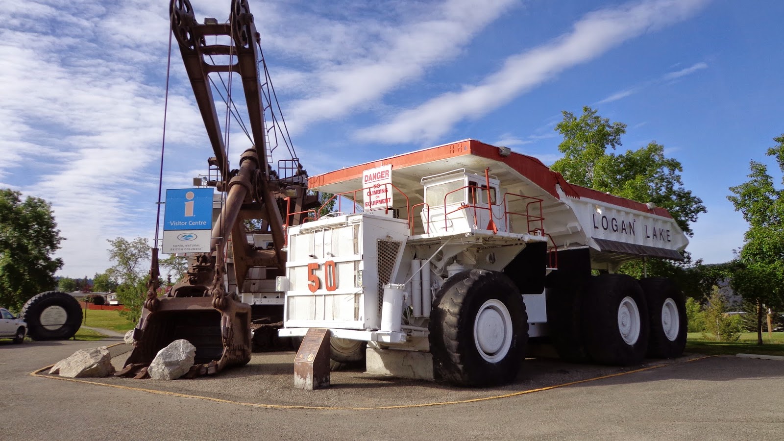
By far the biggest reference point in Logan Lake is the giant mine shovel and it's neighbouring terrain moving mine truck. Both of these "small" units are now retired and serve as the local tourist centre. Many a city folk, (me included), have parked their geomobile next to the truck and snapped a picture to compare the "hugeness" of these mine machines to our tiny on-road vehicles. As it was, this was also the site of our first cache, which was doubly convenient as this was also the site of the community centre where the automotive swap meet (remember me mentioning that) was taking place and the whole genesis of the idea of the road trip!
As the idea of an automotive swap meet bores me to death, I took the opportunity to wander around the show and shine to snap a few pictures of the trucks. Yes trucks...as I am a "Jeep guy" first, followed a close second by being a "truck guy", I was more interested in the old trucks turned out in their Sunday best.
Here's a picture expressly for my "corn binder" loving friend Fred whom has had his old IH sitting in his driveway for longer than my kids have been around (and they are married now) swearing one day he'll get it back on the road! :)
After wandering around the show and shine, I went back to the geomobile and had a nice snooze in the sunshine...ahh, life is good sometimes...
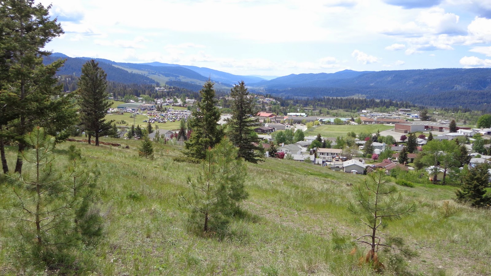
Eventually we started caching again, picking up some of the in-town caches in small parks and a couple of Gold Country caches like the one above called "Birth Place Of Logan Lake". This one provided a good viewpoint of the city and the valley below the hill
.
Here's a good delegation of chores....MrTJ points out the cache to Bowser98, Bowser98 digs the cache out and signs the log, and tjguy98 (me) snaps a picture for posterity.
After Logan Lake, we cached all the way back to Merritt, where we popped into town for a late lunch that we knew would have to hold us over until late at night. We were going to head home to Vancouver today via Spences Bridge and we knew once we got on the road we probably wouldn't be back in Hope until 8.00 or 9.00 PM at the earliest.
The road to Spences Bridge is filled with history, from local First Nations to early European pioneers.who farmed the land, and were eventually buried in that same land.It was a hard life, only a generation or two back from us, but it was a whole different world.
And through it all, the life lines of the day ran non-stop taking produce to markets in the near cities and as far away as Vancouver, transported needed goods to your homestead, and took you away.to places so far away they seemed like travelling around the world. The railway...or railways, as there were many independently owned ones at the time, cut straight lines through the towns and valleys as they worked their magic on our fore fathers. Above is an old railway bridge over the Nicola River, still standing 100 years later.
As we got closer to Spences Bridge it starting getting hotter, like the heat you feel in Lytton in the middle of summer. We had crossed into another geo bioclimatic zone, of which there are 14 in BC, and the heat had us driving with the windows down even at highway speeds. Hoodoos appeared along the Nicola River and with the sun on the decline the walls of the cliffs were bathed in golden light...absolutely the perfect light to show off the sandstone's natural colours.
If you haven't already, click on the above pictures to see them full size and see the natural erosion of the cliffs.
We crossed the Nicola River one last time knowing that just a few miles down the road was Spences Bridge and our last caching stop of the day. We picked up a few new caches that had appeared since our last visit to town, then high tailed it down the Thompson canyon to Lytton, where the Thompson River merged with the Fraser River, and then followed the Fraser River as it ran through picturesque Fraser Canyon all the way to Hope.
A quick stop at the local Timmy Ho's for a bowl of chili and a coffee provided energy for the 90 minute drive back into town. MrTJ and Bowser98 dropped me off at my door at 10.30 PM, and then headed home themselves.
It was a whirlwind two day tour were we combined sight seeing, a swap meet, and geocaching into one big fun trip. We found around 100 geocaches, which isn't a world record by any means, but it was plenty for us as the geocaches took us to beautiful places, all the while teaching us some history about Super Natural BC.
After 18 years of service my 1998 Jeep has taken a rest. In its place is a 2016 Ford Edge. My love of exploring has not changed, and at the root of all my travels is the love of finding something new. It's on these pages I've written travel logs to describe my wanderings. I hope you enjoy the stories ...
Showing posts with label Logan Lake. Show all posts
Tuesday, June 10, 2014
Monday, July 06, 2009
Gold Country Caching - Cache Creek
Had the good fortune to do a road trip to Cache Creek for the kick off of the Gold Rush Event on this past Saturday. Cache Creek is one of 6 B.C. Interior cities that have benefited from government funds to help the local economy recover during this economic downturn.
Cache Creek, Lillooet, Lytton, Clinton, Logan Lake and Merritt were all part of the Gold Rush Geocaching program designed to bring tourism dollars into the cities.
Aprrox 72 caches were placed between the cities and surrounding areas, highlighting the historical locations and at the same time, bringing in a new wave of tourists, in this case geocachers.
I had the pleasure of sharing the day's journey with Scruffster, also known in real life as Stu. I have travelled a fair amount in BC, as have many other cachers, and know the lower part of BC fairly well. Spending a day with Stu is always a treat, first because he's just basically a great guy; second, sharing a road trip with a person who doesn't see this part of the world very often reminds myself of why I like travelling as much as I do. Stu's excitement is contagious, and it leads me into enjoying the trip that much more.
The gawd awful time of 6.00 AM was the pre-arranged meet time in Maple Ridge where Stu would leave his car and jump in the Jeep. That meant I had to get up around 5.00 AM, and Stu was up even earlier....I think Stu was up at 4.00 AM !
We met up, loaded Stu's things into the Jeep, and then set off eastbound and down on the Lougheed Hwy.
We did a cache in Chilliwack just to warm up, but we should have taken this as an omen; it was a real, simple hide, that took Stu and I the better part of 15 minutes! Sadly, our caching skills would not improve much on the day.
We then travelled up the Fraser Canyon, with Stu shooting video for me where possible and firing off his own camera when ever he could. We stopped at the old Alexandra Bridge, then stopped just up the road at the Alexandra Lodge where we took some more shots of the old building and made note of the start of the First Brigade Trail, a Hudsons Bay Brigade Trail that wound over the mountains into the Coquihalla Valley.
Back on the road we stopped again at Hell's Gate to have a look over the edge at the river and building complex down below. While filming here, the gondola cars moved; one went down and one came up; on the one coming up, a woman was sitting out on the structure of the large arm that attached the car to the cable. She was obviously a tech checking the cable for wear and tear; if you think it's scary enough inside the car suspended over the canyon, try sitting outside above the car in a seat barely big enough for your bum! Didn't seem to faze her though....
From there we basically made a bee line for Cache Creek to make it in time for the 11.00 AM dead line where they would hand out the locations of the caches. We arrived at 10.30, which gave us time to sign in, put our name in for door prizes, and eat some of the large geocaching cake made especially for the kick off festivities.
At 11.00 AM precisely, a book was handed out to the cachers; the book contained not just the caches for Cache Creek, but for the other cities as well. Each cache had two pages dedicated to tell the historical significance of the area so that we may appreciate the history presented to us as we looked for the cache.
The cache pages also had parking co-ordinates, and the actual cache co-ordinates, it even gives the cache co-ordinates in UTM. Plus, as an added incentive to those non-cachers, the cache is also designed as a letterbox type. That means, rather than being provided with GPS co-ordinates, you are supplied with a set of instructions such as "walk 10 feet past the last fence post, then turn right and count 20 steps till you reach a large boulder". This way, even non-cachers can still be drawn to the local historical locations and have a chance to re-live the past.
Having this book is a great idea; you can pick up the book from the local tourism office, then as you travel through the Interior of BC following the Gold Rush Trail, you can pick and choose which caches to do, at the same time be educated about the history of the province.
The benefit to the communities is that they have now created themselves as a destination point, rather than a drive-through town. This will pay dividends in time for the local business owners; here's an example I over heard from just one couple this weekend; they arrived Friday night, head a few drinks in one of the local pubs, went over to a restaurant and had dinner, then stayed at a motel. In the morning they got up, had breakfast, started caching, had lunch, gassed up the car, had dinner and then headed home to Vancouver. Each one of those businesses benefitted from the Gold Rush campaign as, more than likely, they would have not even stopped and would have carried on to another destination like Kamloops.
Scruffster and I cached the morning away in Ashcroft and Cache Creek meeting up with several other cachers at various cache locations as we all searched for the elusive treasure hidden by the local Gold Rush group. The morning passed quickly and soon it was after lunch before we knew it.
We met up with another set of Vancouver area cachers called MSthebrain and Pinky, and decided to travel together as we started thinking about a route home. We decided by heading south-east we could hit Logan Lake and Merritt, two other participating cities in the Gold Rush event. This enabled us to pick up 12 event caches on the day; 12 more and we can send away for a special prize which I understand is a gold nugget... "hmmmm....gold......"
We had a great day doing the road trip, we had a ton of fun doing the Gold Rush caches and learning the history of the areas, and we had absolute blast spending time with MSthe brain and Pinky, they made the long trip home seem so much shorter.
AND, we got to share their finding of their 3,000th cache...only we didn't know it at the time and I'm not sure if they did either! :)
The road trip ended up being 750 K and 17 hours long, but I would do it again in a heart beat if I could. It was the two things combined that make up the core of a geocacher; exploring the open road and exploring new areas and finding new caches. In other words, just exploring is what drives a lot of us; that curiosity to see and find something new!
A big thanks to the Gold Rush staff who put this event together, and congrats to their cities for having the foresight to look at a new form of low impact tourism.
I have split the day's journey into two videos loaded up to YouTube. You can see them watch here or by going to my YouTube page here to view them and other geocaching videos I have done.
Cache On!
Cache Creek, Lillooet, Lytton, Clinton, Logan Lake and Merritt were all part of the Gold Rush Geocaching program designed to bring tourism dollars into the cities.
Aprrox 72 caches were placed between the cities and surrounding areas, highlighting the historical locations and at the same time, bringing in a new wave of tourists, in this case geocachers.
I had the pleasure of sharing the day's journey with Scruffster, also known in real life as Stu. I have travelled a fair amount in BC, as have many other cachers, and know the lower part of BC fairly well. Spending a day with Stu is always a treat, first because he's just basically a great guy; second, sharing a road trip with a person who doesn't see this part of the world very often reminds myself of why I like travelling as much as I do. Stu's excitement is contagious, and it leads me into enjoying the trip that much more.
The gawd awful time of 6.00 AM was the pre-arranged meet time in Maple Ridge where Stu would leave his car and jump in the Jeep. That meant I had to get up around 5.00 AM, and Stu was up even earlier....I think Stu was up at 4.00 AM !
We met up, loaded Stu's things into the Jeep, and then set off eastbound and down on the Lougheed Hwy.
We did a cache in Chilliwack just to warm up, but we should have taken this as an omen; it was a real, simple hide, that took Stu and I the better part of 15 minutes! Sadly, our caching skills would not improve much on the day.
We then travelled up the Fraser Canyon, with Stu shooting video for me where possible and firing off his own camera when ever he could. We stopped at the old Alexandra Bridge, then stopped just up the road at the Alexandra Lodge where we took some more shots of the old building and made note of the start of the First Brigade Trail, a Hudsons Bay Brigade Trail that wound over the mountains into the Coquihalla Valley.
Back on the road we stopped again at Hell's Gate to have a look over the edge at the river and building complex down below. While filming here, the gondola cars moved; one went down and one came up; on the one coming up, a woman was sitting out on the structure of the large arm that attached the car to the cable. She was obviously a tech checking the cable for wear and tear; if you think it's scary enough inside the car suspended over the canyon, try sitting outside above the car in a seat barely big enough for your bum! Didn't seem to faze her though....
From there we basically made a bee line for Cache Creek to make it in time for the 11.00 AM dead line where they would hand out the locations of the caches. We arrived at 10.30, which gave us time to sign in, put our name in for door prizes, and eat some of the large geocaching cake made especially for the kick off festivities.
At 11.00 AM precisely, a book was handed out to the cachers; the book contained not just the caches for Cache Creek, but for the other cities as well. Each cache had two pages dedicated to tell the historical significance of the area so that we may appreciate the history presented to us as we looked for the cache.
The cache pages also had parking co-ordinates, and the actual cache co-ordinates, it even gives the cache co-ordinates in UTM. Plus, as an added incentive to those non-cachers, the cache is also designed as a letterbox type. That means, rather than being provided with GPS co-ordinates, you are supplied with a set of instructions such as "walk 10 feet past the last fence post, then turn right and count 20 steps till you reach a large boulder". This way, even non-cachers can still be drawn to the local historical locations and have a chance to re-live the past.
Having this book is a great idea; you can pick up the book from the local tourism office, then as you travel through the Interior of BC following the Gold Rush Trail, you can pick and choose which caches to do, at the same time be educated about the history of the province.
The benefit to the communities is that they have now created themselves as a destination point, rather than a drive-through town. This will pay dividends in time for the local business owners; here's an example I over heard from just one couple this weekend; they arrived Friday night, head a few drinks in one of the local pubs, went over to a restaurant and had dinner, then stayed at a motel. In the morning they got up, had breakfast, started caching, had lunch, gassed up the car, had dinner and then headed home to Vancouver. Each one of those businesses benefitted from the Gold Rush campaign as, more than likely, they would have not even stopped and would have carried on to another destination like Kamloops.
Scruffster and I cached the morning away in Ashcroft and Cache Creek meeting up with several other cachers at various cache locations as we all searched for the elusive treasure hidden by the local Gold Rush group. The morning passed quickly and soon it was after lunch before we knew it.
We met up with another set of Vancouver area cachers called MSthebrain and Pinky, and decided to travel together as we started thinking about a route home. We decided by heading south-east we could hit Logan Lake and Merritt, two other participating cities in the Gold Rush event. This enabled us to pick up 12 event caches on the day; 12 more and we can send away for a special prize which I understand is a gold nugget... "hmmmm....gold......"
We had a great day doing the road trip, we had a ton of fun doing the Gold Rush caches and learning the history of the areas, and we had absolute blast spending time with MSthe brain and Pinky, they made the long trip home seem so much shorter.
AND, we got to share their finding of their 3,000th cache...only we didn't know it at the time and I'm not sure if they did either! :)
The road trip ended up being 750 K and 17 hours long, but I would do it again in a heart beat if I could. It was the two things combined that make up the core of a geocacher; exploring the open road and exploring new areas and finding new caches. In other words, just exploring is what drives a lot of us; that curiosity to see and find something new!
A big thanks to the Gold Rush staff who put this event together, and congrats to their cities for having the foresight to look at a new form of low impact tourism.
I have split the day's journey into two videos loaded up to YouTube. You can see them watch here or by going to my YouTube page here to view them and other geocaching videos I have done.
Cache On!
Labels:
Ashcroft,
Cache Creek,
caching,
coquihalla,
Fraser Canyon,
Fraser River,
geocaching,
Gold Country,
Hell's Gate,
Logan Lake,
Merritt,
TJGUY98
Subscribe to:
Posts (Atom)