Showing posts with label Abbotsford. Show all posts

Sunday, January 10, 2021

Aimless in Abbotsford


Been a while since I have been Out and About, as the saying goes. Between Covid restrictions and the onset of the poor weather, I have been doing a lot of staring at my collection of video and photography equipment hoping I get a chance to use it again.

This Sunday was an unexpected day where we had nothing on the agenda, and pretty well all the chores were up to date. An break in the non-stop chain of rain storms meant a few hours of dry time for me to be out wandering around.

I kept it simple, I picked my trusty point and shoot camera, and headed to the Fraser Valley town of Abbotsford. I knew of a few eye worthy places to snap some pics, and thought I would explore some of the little sides streets I had not been down before.

To see these pictures in a larger format, click on any photo.

Go ahead, you know you want to !


My first side excursion of the day was to poke around Matsqui, a farming community on the north side of the Fraser River. Straight roadways lined with trees planted as windbreaks is a hallmark of farming areas and there were plenty examples to be seen here.

The flat farming terrain also provided views of the low clouds enveloping the low mountains forming the ridge of the Fraser Valley. 


  The clouds clung to the higher mountains on the northside of the valley even more so, blocking out any scenic shots to be had in that direction.


After dawdling in Matsqui I headed over to main main objective for the day, the Township of Abbotsford. And now you are wondering, what's so special about these two buildings in the picture above? Well, if you have ever watched those Hallmark TV movies you would have seen these two buildings in many of those movies. At least, that is what my wife tells me ..  yeah ....

Vancouver is called Hollywood North and it is not uncommon to have two dozen TV/movies shoots ongoing at any given time. One of the most common movie channels to shoot in the area is Hallmark. For some reason they seem to love this two buildings - they are either using the older white building or the larger brick building as a main movie location. Seeing as I was already here exploring Abbotsford,  I naturally had to see for myself where these were actually located.


The Hallmark buildings are located in the old section of Abbotsford, which is roughly five blocks squared. I parked the car and meandered around the side streets and alleys looking for worthy subjects and came across the murals seen here. They encompass the back of the Hemmingway's book store, a very large and popular used bookstore in town. A lot of time was spent by the artists painting these vibrant murals and they look great and add life to a forgotten back alley.


A few years ago the Downtown association commissioned several sculptures to add to the visuals of the area. These three guys are very lifelike and have been in many a tourist photo. I also have snapped them a few times over the years.


The Goose in the Truck adds a touch of whimsy to the scenery, I have to admit, this Goose looks like he has real attitude! I can just imagine him leaning on the horn yelling for people to get out of his way! Must have received his license in downtown Vancouver  :)


The "art" scene is represented as well with a bench in the form of a large easel complete with dripping brush, all supported by a squeezed out tube of paint. Sadly the surface of this bench is in need of some TLC. Would look so much more vibrant if it was cleaned up and resurfaced.


 After exploring more of the downtown side streets, I decided to head towards another historic section of the general Abbotsford area, in the village of Clayburn. As I drifted in that general direction I kept my eye out for anything that caught my eye. And this sure did - Snoopy flying a Sopwith Camel airplane! I spotted this in someone's backyard mounted high for all to see from the street. That was definitely worth a stop to snap a picture - great job by the resident ! 


I took the long way around as I headed into Clayburn as I wanted to reach higher ground to obtain an aerial view of the surrounding area. I had circled back towards the Fraser River and was getting close to the Matsui farmlands again. Clayburn is nestled against those low mountains seen in the first scenic picture of this post. These low mountains have something needed for building construction at the turn of the century - clay. Perfect for molding into bricks and when heated and fired, perfect for building brick buildings.


I have been to the village of Clayburn several times over the years but only to look at the old General Store and the ruins of the brick ovens in the nearby bush. 


Today very little remains of the original town buildings. A few brick bungalows that were workmen cottages, and the General store. The land where the original factory buildings stood seems to have been cleared and is now a soccer field. It is quite possible they have bulldozed away the old kiln ovens. In the past, when I have walked through the bush, you would stumble upon a pile of brick rejects that broke during the firing process, so they were just dumped outside in a pile. I have retrieved a few bricks from those piles, all bearing the Clayburn name. So popular were the bricks, it was not uncommon for me to discover historic buildings in other cities in Southern BC built by bricks bearing the Clayburn name.


Today I spent an hour or so walking the side streets and discovered the original Clayburn School, and the Clayburn Church, which were new to me. These two building were only a block off the main street,  but I had yet to see them in all my travels in the area. Thus proving one of my favourite adages - "take the road less travelled, for there is more to see" 


These two buildings leant an air of charm to the small village and you could imagine the town folk of the day actively using the buildings as part of their daily lives. While the visible remaining structures from the original Clayburn townsite are small, they still allow you envision a time when the brick factory and the local community compromised the entire world for the work force. Vancouver probably seemed a long ways away. In the day, a trip to Vancouver was an all day event using the B.C. Electric train that ran from Chilliwack to Vancouver, with stops at various Fraser Valley communities along the way.


My last stop of the day was back across to the north side of the Fraser River into the town of Mission. Originally a major First Nations community, the first Europeans were Oblate priests whom established a mission high on the hill above the river.


With the coming of the CPR railroad, the city itself was created through a land auction by the stake holders of the railroad. Farming was the original economy of the area, however the salmon industry soon became a driving force as well. Five species of salmon inhabit the Fraser River, providing a large industry to exploit. White Sturgeon are found from the Mission Bridge, upstream to the town of Yale in the Fraser Canyon. The White Sturgeon live for over 100 years and grow up to 20 feet long. The sturgeon are true dinosaurs, as they have not changed much in millions of years.  
Supplementing the fishery industry was the boat and net repair companies. While many of these businesses have died off, the small industrial riverfront area shows its heritage by the businesses along the side streets    


The shore front has been cleaned up allowing for pedestrian access. A large viewing platform has been created for the locals to rest and sit on the benches while they enjoy their coffee watching the comings and goings of the local ship traffic. The local mountains complement the view by providing a scenic backdrop for daily life on the river. Like Abbotsford, Mission City has begun to install pieces of art around the city. With its large First Nations presence, some of the pieces have been created by local native artists. The Bald Eagle sculpture shown here represents the importance of the eagle in First Nations history. The statue also serves as a reminder of when the Bald Eagle congregate in the area each Winter. Just to the east of Mission is the Harrison River.  Each winter thousands of Bald Eagles migrate south from their summer grounds in Alaska and spend the winter feasting on the salmon runs in the Pacific Northwest. The primary winter feeding grounds are; just north of Squamish in the town of Brackendale; in the Harrison River area of the Fraser Valley; and in the U.S. south of the border in the upper Skagit River Valley. I've been to all three locations during the winter feeding times, and by far the Harrison River offers the most accessible viewing of the eagles. 


   By now the day was coming to an end, as daylight was beginning to wane, and the small bits of open skies were being replaced by darker clouds. Another round of rain storms are on the way, but at least I enjoyed a long overdue day of being Out & About in my extended "backyard" compromised of the 100 mile long Fraser Valley. Time to head home, download my pictures and see what I captured of the day.

If you liked the write up please leave a comment below.
A more complete set of the day's pictures can be viewed on my Flickr site here     
   

Tuesday, June 10, 2014

On A Mission To Merritt

Okay, technically that's not quite true...we were on a mission to Logan Lake....but "On A Mission to Merritt" sounds better as a title than "Lollygagging in Logan Lake"!

The complete set of pictures of this trip and other trips can be seen at my Flickr photo web site here

I had a few days off recently, and with MrTJ and Bowser98 being retired, they had a few days off as well. Bowser98 was toying with the idea of going to Logan Lake to see the automotive swap meet on Saturday and I suggested to MrTJ that we turn it into a two day geocaching road trip hitting Merritt, Logan Lake and places in between.Wow, was it hard to twist their arm!  :)

As Merritt is only a 3 hour drive from the Coast, we decided to spend most of the day caching in Abbotsford and Chilliwack, adjusting our schedule as required as we planned our arrival in Merritt to be around dinner time to ensure we secured our motel room.

The first couple of caches were roadside caches, no big deal there but we did start off with that warm fuzzy feeling of going 2 for 2 on the day. One of the caches we looked for had been in place for a while but the area was being over run by black berry bushes. Bowser98 got his whacking tool out of his truck and he and MrTJ took turns whacking back the bushes until we had access to the cache. Some brambles were hurt in the hunt, but they evened out the score by drawing blood in return.

We found a few caches around two side-by-side cemeteries in Abbotsford, which gave us 9 caches in close proximity to each other..always good to save driving time. And as this was June 6, D-Day, it highlighted the sacrifices our men and women made, and continue to make, to ensure our freedom and our way of life.


We then moved out of Abbotsford, slowly making our way towards Chilliwack. One of the fun caches we found was on a farmer's piece of lawn art - an old truck cut down to fit on a corner of the yard fronting the rural road. This was kind of neat to see, and neat to think that the property owner had the whimsical thought of putting this piece of truck out there on display. And kudos to the owner for allowing a geocache to be put there for us to enjoy it as well.

Click on any picture to enlarge it to experience the full magic! 


We did a few more caches in Chilliwack, mindful of the time of day and skipping some more from the agenda as time got tight. I really wanted to ensure we caught three caches that were old stone obelisks that were mile markers used way before the freeway came into existence. From the main Canada Post Office on Georgia Street in Vancouver to Hope approx 100 miles away, there was an obelisk every mile that let you know how far you had gone. The ones we would be finding were #58, #59, and #60; I had previously found these but wanted to show them to my brothers for their historical coolness..


We scooted up to Hope to pick up a couple of quick caches that were new since last time we came through town; one of them was at the old train station, (every town has one of these). This one, as many are, is being maintained by a local heritage committee which is determined to preserve the town's history. This station had the double pleasure of seeing George VI and Queen Elizabeth in 1939 as they made a stop here on their cross country tour, and, of seeing Princess Elizabeth and Prince Phillip when they made a stop in October of 1951.


With our reminiscing of royalty over, we headed up one of the new royalty of roads...that being the Coquihalla Highway. A wonder to behold in summer, it's a true nightmare to drive in winter; it's not uncommon for this highway to get 2-3 feet of snow overnight courtesy of winter storms. Lucky for us we were in the beginnings of summer, and while we did see some snow still clinging to the high peaks, we were safe down at road level


We were soon getting close to Merritt, time to start finding some historical caches, and by that, I mean caches that took us to historical locations. A few years back, the BC government through Tourism BC offered funds to the Thompson Valley area, which included towns like Merritt, Logan Lake, Ashcroft, Lytton, Lillooet, and as far north as Cache Creek and Clinton. One of the schemes that came out of this was to lure geocaching tourists to the area with a series of geocaches highlighting the Gold Rush days of BC.


In .Phase 1 there were 72 geocaches hidden at historical locations such as at this last remaining train water tower from the Kettle Valley Railway; this tower was rare as the KVR was the only railway that built 5 sided towers. This one is located in the small village of Brooksmere just off the Coquihalla Highway.

Other locations highlight long-gone mining towns, pioneer farms, and any historical place that was involved with the Gold Rush. The geocaches are well made containers, and stocked with stickers that you collect to put in your Gold Rush book to show you been there - you take a second sticker and send in 24 of them on a sticker page to obtain a collectible gold bar geocoin....so far I have one of them and should be close to qualifying for a second one.


We eventually cached our way into Merritt, popped into our hotel to secure our room for the night, then headed back out on the road to continue caching until we got tired, or hungry, or it got too dark...which ever came first.


One of the series of geocaches I like in Merritt is by a cacher named Mole60 which highlight the back roads around Merritt. These caches lead you to pristine views of rural life where the only sound you hear are the birds around you and the occasional call of livestock on the nearby farms.


Another cache series I like is called "A Taste Of The Valley" done by Dumbo09; this set of caches lead you around Merritt and surrounding areas as you get a taste of the Nicola Valley from early pioneer days through to the last generations childhood memories. Following this set of caches from place to place is like having your very own tour guide sitting in the back seat.


We finished off in Merritt at 9.30 PM, just as the last of the sun's rays were setting...time to hit a local eatery and have a late supper, then head back to the motel for trip planning the next day as we had Logan Lake in our sights.


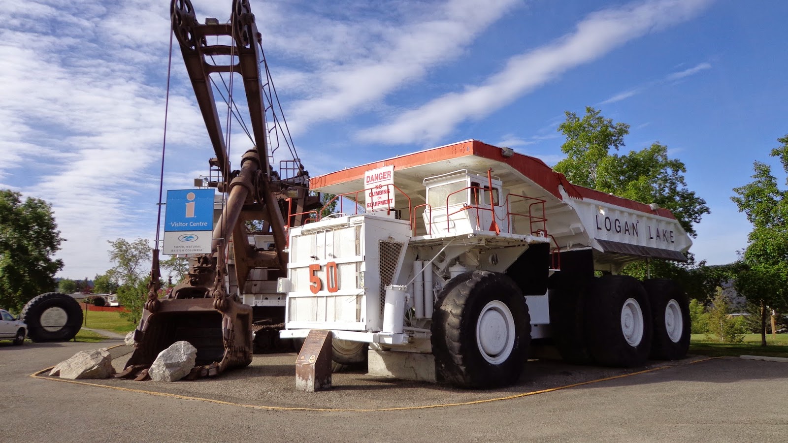
By far the biggest reference point in Logan Lake is the giant mine shovel and it's neighbouring terrain moving mine truck. Both of these "small" units are now retired and serve as the local tourist centre. Many a city folk, (me included), have parked their geomobile next to the truck and snapped a picture to compare the "hugeness" of these mine machines to our tiny on-road vehicles. As it was, this was also the site of our first cache, which was doubly convenient as this was also the site of the community centre where the automotive swap meet (remember me mentioning that) was taking place and the whole genesis of the idea of the road trip!


As the idea of an automotive swap meet bores me to death, I took the opportunity to wander around the show and shine to snap a few pictures of the trucks. Yes trucks...as I am a "Jeep guy" first, followed a close second by being a "truck guy",  I was more interested in the old trucks turned out in their Sunday best.


Here's a picture expressly for my "corn binder" loving friend Fred whom has had his old IH sitting in his driveway for longer than my kids have been around (and they are married now) swearing one day he'll get it back on the road!  :)

After wandering around the show and shine, I went back to the geomobile and had a nice snooze in the sunshine...ahh, life is good sometimes...


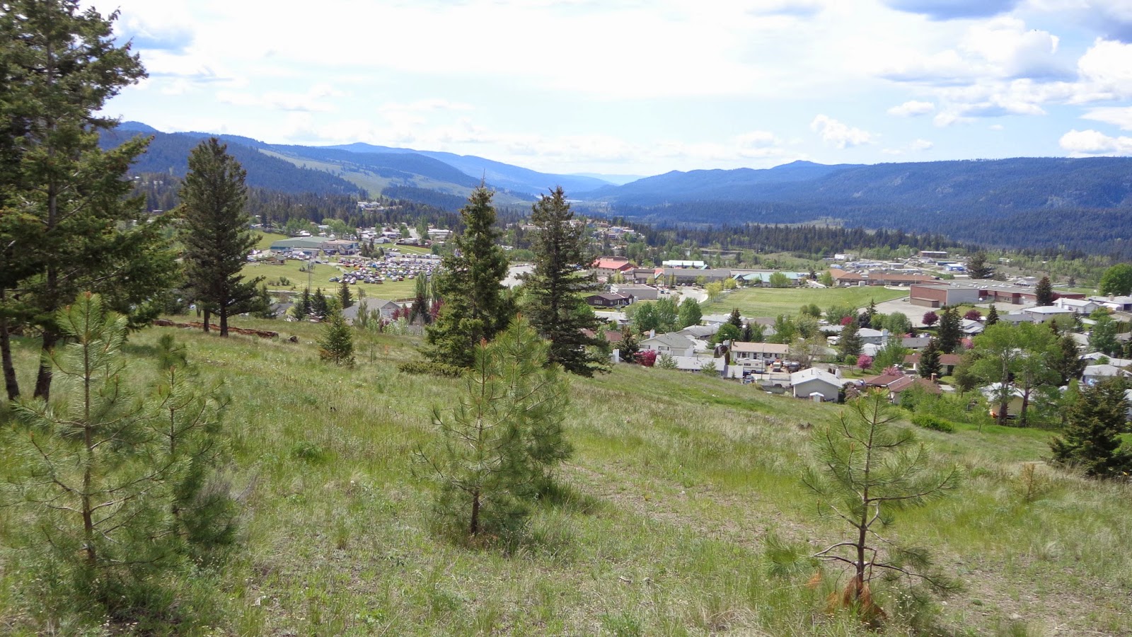
Eventually we started caching again, picking up some of the in-town caches in small parks and a couple of Gold Country caches like the one above called "Birth Place Of Logan Lake". This one provided a good viewpoint of the city and the valley below the hill
.

 Here's a good delegation of chores....MrTJ points out the cache to Bowser98, Bowser98 digs the cache out and signs the log, and tjguy98 (me) snaps a picture for posterity.


After Logan Lake, we cached all the way back to Merritt, where we popped into town for a late lunch that we knew would have to hold us over until late at night. We were going to head home to Vancouver today via Spences Bridge and we knew once we got on the road we probably wouldn't be back in Hope until 8.00 or 9.00 PM at the earliest.


The road to Spences Bridge is filled with history, from local First Nations to early European pioneers.who farmed the land, and were eventually buried in that same land.It was a hard life, only a generation or two back from us, but it was a whole different world.


And through it all, the life lines of the day ran non-stop taking produce to markets in the near cities and as far away as Vancouver, transported needed goods to your homestead, and took you away.to places so far away they seemed like travelling around the world. The railway...or railways, as there were many independently owned ones at the time, cut straight lines through the towns and valleys as they worked their magic on our fore fathers. Above is an old railway bridge over the Nicola River, still standing 100 years later.


As we got closer to Spences Bridge it starting getting hotter, like the heat you feel in Lytton in the middle of summer. We had crossed into another geo bioclimatic zone, of which there are 14 in BC, and the heat had us driving with the windows down even at highway speeds. Hoodoos appeared along the Nicola River and with the sun on the decline the walls of the cliffs were bathed in golden light...absolutely the perfect light to show off the sandstone's natural colours.


If you haven't already, click on the above pictures to see them full size and see the natural erosion of the cliffs.


We crossed the Nicola River one last time knowing that just a few miles down the road was Spences Bridge and our last caching stop of the day. We picked up a few new caches that had appeared since our last visit to town, then high tailed it down the Thompson canyon to Lytton, where the Thompson River merged with the Fraser River, and then followed the Fraser River as it ran through picturesque Fraser Canyon all the way to Hope.
A quick stop at the local Timmy Ho's for a bowl of chili and a coffee provided energy for the 90 minute drive back into town. MrTJ and Bowser98 dropped me off at my door at 10.30 PM, and then headed home themselves.

It was a whirlwind two day tour were we combined sight seeing, a swap meet, and geocaching into one big fun trip. We found around 100 geocaches, which isn't a world record by any means, but it was plenty for us as the geocaches took us to beautiful places, all the while teaching us some history about Super Natural BC.

Thursday, April 24, 2014

Llamas, Horses, and Water - Geocaching in Abbotsford

Brother Ken AKA MrTJ and I spent the day geocaching in the north part of Abbotsford enjoying one of those sunny days that alternate with the rainy days that early Spring brings. Most of north Abbotsford is rural, split between full fledged farms and small hobby farms where people enjoy a bit of freedom to raise chickens, goats, horses and what ever else they fancy.

Click on any picture to see them full sized - then you'll get the full magic!  :)

Many of these hobby farms have a llama or two mixed in with the herds as llamas are excellent protectors against predators like raccoons, coyotes, and other creatures that fancy an easy meal.

We started the day just outside of Fort Langley, well, truth be told we started the day in Fort Langley as MrTJ required some fortitude in the form of a coffee and a cookie. Having got that out the way, we headed just outside of the historic town to find our first cache which was located on a small suburban trail. We had actually been here before finding another cache that has since been archived, so we knew the closest parking and entrance point to the trail. We only had to go a few hundred feet up the easy gravel path, but we took a few minutes to once again enjoy a hobby farm that was situated on a small hill above a pond that came fully equipped with Canada geese, Mallard Ducks, and your own canoe to slip among the water fowl.

  This was a good trail to stretch out the muscles and to get the blood flowing - easy walk to the cache, not far to go, and no coffee was spilt on the way. Best of all, a quick find was an omen of good luck on the day!

The next few caches brought us back down to the Fraser River's edge and took us along River Road as we picked up caches heading east away from Fort Langley.It also brought us down into the Glen Valley region of Langley. This is a pocket of flat land sandwiched between the uplands and the Fraser River. It's also one of the earliest farm land areas utilized by Europeans in conjunction with the operation of Fort Langley when it was a Hudson's Bay Trading Post.

The land is now diked to protect it from flooding, and a long irrigation canal operates as both a source of water for the fields and a drainage mechanism during high water levels. We found a couple of caches in the area and took time to read the nature information boards posted at this popular walking area.Always love reading these as that's how you learn about your local world; not just the present day, but the history of the land and the people that lived here.

 The next cache of significance brought us to Two Bit Bar, site of a historic farm house and now part of the long, linear Glen Valley Park. This cache is called "VTMP # 59 Two Bit Bar"
VTMP stands for Vancouver Transit Memorial Project and it highlights a now defunct type cache known as a "moving cache". The ideas was you would find the cache, pick it up and go hide it in another location within specified geographical boundaries.This one had a wide range - anywhere in the Greater Vancouver area, that's a big area to hide it in! Once you hid it, you would post the co-ordinates on the cache page for the next cacher(s) to race to find it and re-locate it again. I myself have one of these memorial caches hidden in east Maple Ridge at Arnold Falls in Kanaka Creek Regional Park.

 The next cache was deja vu, as it was hidden at a location where I had hid one a few years before. My cache was called "Bob's View" as my work buddy Bob lives right across the river and this is the view he has of the river.
The boat shed in the picture above belongs to Bob - his house is on the hill to the left, partly hidden by the brown building.
My cache lasted for a couple of years before an extremely high spring runoff floated my cache downstream to disappear forever, or so I thought. A year later I received an email from a fellow geocacher, whom worked in New Westminster on the log booms as a log sorter, stating he had found my cache floating in the Fraser River among the log booms! WOW! I met him at a geocaching meet up a couple of weeks later and he returned my cache; he also said that this was the second time he had found a geocache that had run away and ended up in the log booms.

River traffic provided many a picture opportunity and I think MrTJ was getting a bit bored after a while as I was more about the pictures and less about the caching. No worries MrTJ, I can do both "cause I'm a guy"!

We picked up a few more river side caches and then retraced our steps a few miles back to head to the uplands of north Abbotsford known as Bradner.
Bradner was another historic area situated right atop the hill with a commanding view of the Fraser River, and well above the annual flooding I might add.

The area was a small knit community where everyone seems to know everyone and we were decidedly the outsiders. I assume that, as this area is rural and far from the normal patrol area of the police, the Neighbourhood Watch program was in place as every where we went among the rural acreages or hobby farms we got the beady eyeball.

We really liked it around here - it was quiet and peaceful, lots of space between you and your neighbours, you can make a bit of noise or run some machinery in your yard with out the neighbour complaining. We found two caches at the local baseball fields that were part of the school, and the kids whom played in the school yard had a horse as a neighbour - granted he wasn't much on conversation, but he probably found all these rug rats running around mildly amusing  :)

One of the caches had us threading our way on a short trail that ran along the top of a ridge line in a ravine area. Doesn't look like much in the picture (go ahead, click on the picture and make it bigger) but a simple trip over a tree root or your own feet would have you rolling 50 feet down the hill.

This ravine area also showcased why they say Vancouver is in a coastal rain forest area; Muddy slopes and heavy moss on the trees indicated that plenty of rain fell here to keep the flora as green and lush as it is.

 As we headed east through the upland area we transitioned from Bradner to the Mt. Lehman rural region. At the base of one of the old local roads that winds it's way down the escarpment to the Fraser River was the location of a bygone ferry that ran across the river from Abbotsford - Mt. Lehman to the north side of the river taken passengers over to East Maple Ridge - Mission territory. I can honestly say that until I had found a couple of caches down that abandoned road I had no idea that a ferry use to run across the river here. That's one of the wonders of exploring through geocaching - learning all about your historical back yard!
The Mt' Lehman library shares the building with the Mt. Lehman Fire Department - small town efficiency, serving all your needs in one location. :)  In the days of big buildings and big libraries and bug everything, this quaint building in a small part of the world made me smile.

We picked up a few more caches as we wound our way into civilization known as Abbotsford; we had picked up most of the rural caches in the northern sector and as the day was winding down I had planned on picking up a succession of rapid fire caches in the city. One of the caches we found touched on a series of caches along an old rail way path that is now a main road that lazily traverses west from Abbotsford back into the Bradner - Langley area. Ken and I had done a cache along this path way a few years ago but we see now that some one has created a whole series along here. I've marked these ones for a definite re-visit as both Ken and I enjoy caches that highlight areas of local historical significance.

With that in mind, I saved one of my favourite type caches to last........this was another in the Mile marker series that highlights cement obelisk mile markers.

When BC highways were young, there was no Highway #1 from Vancouver to Hope; what you had was a series of local roads that took you east from the city of Vancouver to Hope and the lands beyond.
To help you know how far you had traveled on your path, a series of obelisks counting off the miles were created. Starting at the Vancouver Post Office on Georgia Street in downtown Vancouver, you went along Kingsway Street through Burnaby and crossed into Surrey to follow alternately Old Yale Road and The Fraser Highway as you headed east. Most of these mile markers have disappeared as they became obsolete, but through blind luck and restoration, some of them still exist. This one is at Mile Marker 35 at the edge of Aldergrove; 35 miles from Vancouver and another 65 to go until you reached Hope. I have found a few of these, I think the lowest I have found is Mile 30 and the highest I have found is Mile 98 just outside of Hope.

This was the end of the day for MrTJ and I, we had found 31 caches and a lot more. We had started our day in the first Provincial capital city of BC in the name of Fort Langley, then wandered through the farms that fed those pioneers, traveled along side the original highway in BC in the form of the Fraser River, climbed the hills to meander through small communities content in their quaintness, and ended the day at a relic of car travel from 1931. All in all, a very fun and satisfying day was had by all, and you can't ask for much more than that!  

All pictures of this trip and other trips can be seen here at my Flickr web site. You can also click on the link in the left margin of the blog page.