After 18 years of service my 1998 Jeep has taken a rest. In its place is a 2016 Ford Edge. My love of exploring has not changed, and at the root of all my travels is the love of finding something new.
It's on these pages I've written travel logs to describe my wanderings.
I hope you enjoy the stories ...
I've been caching for 5 years now, (doesn't seem that long ago that I found my first cache), and the thrill of the search isn't as strong as it once was.
What is still there is the love of the drive to the cache location, the walk to the cache along some forested path or along the edge of a hidden stretch of seawall along Burrard Inlet, or a gravel path along the wide open expanse of a dyke running along a river's edge which offers a panoramic vista that surrounds us.
However, the real FUN and THRILL of the hunt can only be seen through a child's eyes. Recently I've been given the privilege of sharing that long lost feeling with a very young lady I know named Janelle. She is all of 8 years old, wide eyed and excited as can be to go out and find the treasures that only special people know about.
Her mom and I met at a couple of local caches just to give her a taste of what it's like to look for hidden treasures in the woods. And darned if it wasn't a good thing we did, as she found a well hidden cache that this veteran cacher was having trouble finding.
Her mom and dad do not have a GPS yet, but that doesn't stop Janelle from wanting to go out to find more. As a way of saying "thanks" to her for showing me what's it's like to feel the intensity of a fun day that only a child can, I placed a cache near her house for her to be the FTF on, as well as for her to maintain. Janelle's FTF prize was a small keychain flashlight for checking those dark crevasses in the forest, as well as a small note book for keeping track of her cache notes while she is on the trail. The ownership of the cache I hope will instill a feeling of being a guardian of treasures for another people to enjoy; a way for her to have fun by way of allowing others to have fun finding her cache.
The cache is named "Janelle's Cache" GC1YR1Z located in Coquitlam BC not far from the Coquitlam Centre Shopping Mall. If you have a chance, stop by, find the cache, and take a minute to remember how exciting everything was when you were a child. Those moments are long gone for us adults; we can only reclaim fleeting glimpses of them when we look through the eyes of a child.
After writing trip reports for various web groups I belonged to, such as the Full Size Jeep club and the BackRoads Driver group, both on YahooGroups.com, I decided that I wanted to have my own site where I could post trip reports and stories that crossed multiple interests.
I was originally thinking of having my own web site, but decided that a blog was easier to do and would fill the need. On Oct 2 2006 I launched my blog and added some trip reports and pictures from my "archives".
Here we are, not quite 3 years later, and I now have 74 entries on my blog, and have had over 8,000 visitors! WOW, that's more that ever thought would visit...to be honest I don't know how many I was expecting to visit when I entered the online world.
Things I did foresee; my still writing of trip reports and putting pictures up on my Flickr site so every one could "come" along the trip with me, in the virtual world if not in the real world. I expected some family members and a few close friends and a few 'Net friends to visit over time.
Things I did not foresee? I certainly did not envision having people from around the world take an interest in my site; I did not foresee hits from over 40 countries on my counter; I did not foresee myself getting into video and making short films about geocaching, off-road exploring and other exploits I get myself into.
What really amazes me is how my simple plan of having a web presence has morphed into a larger world of videos, pictures, and stories supported through various media such as a Video editing tool, a Web blog, two web sites to store pictures, and an account on a video web site.
Not to mention the various web groups I belong to and have posted messages to and uploaded my media presentations to. I have even had one of my pictures of England used on www.Schmap.com This is a web site that is a combination map and picture site...
So here's to the next milestone of 10,000; which now doesn't seem that far away...
PS If you want to know how far back I go with my trip reports on the web, here's a clue. I found one of my original stories archived on a friend's web site; the date I wrote the story is May 26, 1997. Have a look at the early web days of Ed at http://wagoneers.com/FSJ/rigs/Eddie/
Thanks for visiting, and if you've enjoyed the site, please leave a comment at the bottom of this article or any other article you've enjoyed.
Annette and I spent a sunny afternoon wandering around Lonsdale Quay in North Vancouver as a way of enjoying a slow day of holidays. The weather was perfect, nice sunshine, just a little bit of clouds, and not too hot.
The Quay is a great place to visit as it has many food shops located on the lower floor where you may buy fresh ingredients for tonight's dinner. If you want to take home your dinner, or enjoy a lunch now, there are plenty of kiosks in the Food Fair area. As well, there are two levels upstairs that offer higher end stores stocked full of cute and unique gifts, games, and clothes. They even have a "Kid's Alley" devoted to shops just for the rug rats.
We have a family friend who's daughter just had a little boy a month or so ago, and Annette is going to the baby shower in a couple of days; we picked up a cute little jumper in Baby Blue with writing on the front. The writing states: "All Mommy Wanted Was a Back Rub"!
When we seen that, we couldn't stop laughing and just had to buy it as the perfect baby shower gift!
ABOVE: The yacht Attessa owned by Dennis Washington
We went outside to meander the Quay dockside and walk the Burrard Dry Dock pier. We opened the door to go outside and the first thing that filled our vision was this HUGE yacht! This thing was massive, and we could only begin to dream about what it must be like to cruise on this vessel.
We walked over to the Burrard Dry Dock pier, which was the old grounds of the Burrard Shipyards were over 450 vessels were made, many of the BC Ferries came from here as well. The pier runs for 700 feet out into the waters of Burrard Inlet, giving you an excellent view of the Vancouver waterfront on the south shore of the inlet. It also gave us an unobstructed view of the Attessa, in all it's glory.
We walked back towards the Quay just as a twin prop 10 passenger float plane came in for a landing and taxied towards the Attessa. We waited for a few minutes and snapped off some shots of the plane landing and then docking next to the Attessa. It was no coincidence that the plane's colourings matched the Attessa, it was also from the Washington group.
We watched as two older gentlemen and one younger man deplaned and headed up the ramp towards the street. We managed to come around and meet them out on the street; we were very interested to see if we recognized anyone.
Well, we didn't, but Annette managed to snap a couple of photos of them anyways just in case. The young fellow looked like he should be a hockey player; about 6'2' with a good build ready to play the position of a tough defenceman. The older gentlemen we did not recognize, sad to say.
We finished up our walk around the piers and shops in the quay, then joined the rush hour crowd back to Maple Ridge. When we got home, the first thing we did was download the pictures, and then start googling the Attessa.......here's what we found out.
First, one of the older gentlemen we passed was Dennis Washington himself, presumably just back from the island resort. The Attessa is 225 feet long, the 16th biggest yacht in the world; it is owned by Dennis Washington out of Seattle. The billionaire owns, among others, the following enterprises: The Washington Marine Group, (who owned the Fast Cat ferries and just sold them to a Middle Eastern buyer), he owns Seaspan Tugs, which was why he was docked there, and he owns a private island on the BC coast complete with a golf course and guest resort. He also owns several airplanes, one which mainly flies in BC ferrying guests and owner from Vancouver to the island resort and back.
The man loves to live in the luxury he can afford, all the power to him! With dreams of yachts and private islands dancing like sugar plum fairies in our heads, we uploaded a few pictures to our web sites, looked at each other, and sighed....."ahhhhh, if only".
Crazy Canyon Caching is an excellent name for this trip report as the whole day fits into the category - just crazy!
Here's the stats on the day; 22 hours on the road, 770K, 12 Gold Country Caches for Cookie Cacher, 12 more for me to obtain my 24 caches required for the Gold coin, a total of 60 caches for me and 66 for Cookie Cacher!
Videos and the GPS route of the day's trip, uploaded to EveryTrails.com, can be found at the end of the write up.
THE STORY
I had been up the Fraser Canyon two weeks ago with Stu, AKA Scruffster, as we blasted our way through the canyon one early morning on our way to Cache Creek to arrive just in time for the official late morning kick off of the Gold Country Geotourism event. The event was being held in 6 cities, Cache Creek, Clinton, Lillooet, Lytton, Merritt and Logan Lake, all in an effort to promote tourism in the area.
All that morning, we kept on passing caches that just begged us to pull over and find them; with broken hearts we passed them by, knowing full well we would be back here soon answering their call. This Saturday we were back, only instead of Scruffster being in the shotgun seat, it was Jeanine AKA Cookie Cacher.
Cookie Cacher had been asking to go caching with me for quite a while, and today seemed like the right time for me to make good on my promise of a day of caching together.
We met up in Maple Ridge at 6.00 AM, me almost sleeping in and waking up only 20 minutes before we had to meet. We met up, both of us semi-awake, loaded Jeanine's stuff into the Jeep, and cruised east out of Maple Ridge aiming for the Fraser Canyon.
We did a couple of caches just north of Hope as a way of warming up on the day, then made our way to Emory Creek area where 4 caches awaited us.
One of the caches highlighted the Emory Creek area, explaining how there was a townsite here in the 1880s; it boasted of 13 streets, two hotels, nine saloons, a brewery, blacksmiths, a general store, and residences. It soon became evident that the CPR would make Yale the terminus of the railroad, and by the 1890s no sign was to be found of Emory City.
Also in the area is a Provincial historic signpost explaining the significant contribution of the Chinese in building the original Cariboo Road, and later the railroads.
We found the 4 caches in the area, then moved on to Yale to look for caches there. In Yale there are several historic places, suchs as the oldest church in BC still on it's original foundation, Lady Franklin Rock, named after Lady Franklin who toured the world while her husband was on his expedition to the Artic.
Another little know fact is that, in 1868 there was a meeting of 26 delegates from all over the colony of BC who were dissatisfied with the colonial government. This convention did much to stimulate popular support for the idea of the Colony of BC uniting with Canada to become a province of Canada.
We finished up in the Yale area, then moved north on our journey, grabbing various roadside caches that highlighted the best scenic viewpoints in the Fraser Canyon, or otherwise little mentioned historic areas.
Another of the more historic spots was highlighted with a cache placed on a trail; not just any trail, but an HBC Fur Brigade Trail.
This one was placed a short ways up the trail next to Alexandra House. Alexandra House was a road house on the original Cariboo Wagon Road, and the fur brigade trail predates the road house. The original road house was torn down and the current one built, supposedly using one or two of the original road house walls. Hard to determine which ones were used, but even so, the current building is pretty old as is.
The cache was located about a 5 minute walk up the trail from the noisy canyon road, but you might has well been 100 miles from anywhere. The trail leads over the mountains into the Coquihalla Valley, on through the Voight Valley, then cuts across the Douglas Lake Ranch holdings on it's way to Fort Kamloops.
In it's heyday, the pack trains of horses were an incredible site; 500 horses packed with large 80 pound bales of fur on each side, requiring 150 men to run the pack. The First Nations people would watch this procession go by in amazement; never had they seen so many "English" men at one time.
In the Gold Rush days, there were two kinds of white man; those that came from America were called "Boston men", as many of the gold seekers came from Boston. Every one else was called an "English men", as most of the non-Americans were English.
This was a great chance to stretch our legs and provided the wonderful experience of allowing us to step back in time, if just for a few minutes, and imagine the sound of many hooves from labouring horses, intermingled with the voices of the packers encouraging their charges to keep moving.
Northward we continued, stopping at more viewpoints and scenic waterfalls till we got to Boston Bar, the site of a bar in the river first worked by American miners, hence the name "Boston Bar". Here we did a couple of caches aimed at highlighting the old suspended cable car that use to run over the Fraser River from Boston Bar on the east side, to North Bend on the west side.
Many an old folks have used this cable car, and can still vividly recall their trips. Years ago the cable car was replaced with a high level bridge to provide more permanent and improved access for the residents on the west side of the river.
In Lytton we came across our first Gold Country caches, where we started collecting stickers to place in our books. We visited a historic church, The Church of St. Mary and St. Paul, and the Lytton cemetery; we also stopped at the Lytton Jelly Roll, so called because, well...it looks like a giant jelly roll. The roll was created in an ice bound lake during the last glaciation period when an underwater landslide caused the sediment layers to slump away. Rather than breaking up and dispersing, the layers rolled up instead to look like a jelly roll.
With jelly rolls on our minds, we scoured Lytton for as many more caches as time would allow, before we headed north once again.
Next stop, beautiful Nicomen Falls; get ready for a great view of a tall waterfall seemingly coming out of a crack in the hill, and a steep short hike to find the cache. This one I looked forward to doing, and I didn't.....I'm no so good on uphills... :(
But, there was no way I was going to pass on this cache just because I had to huff and puff a little bit; besides, I was hedging my bets......I had Cookie Cacher along to perform CPR in case I over exerted myself... :)
As it was, a short, 2 minute hike brought us to the cache location...."well, that was easy"! "What was I whining about"? With cache in hand and cameras going, we took a few minutes to enjoy the area, before the calls of the caches up the road begged us to continue.
Into Spences Bridge we went, criss crossing the small town while we searched for caches at a cemetery, at the oldest Inn in BC, at a small camp ground on the banks of the Thompson River, and at a small cafe called The Packing House.
Caches found, it was time for a "time check"; it was 5.30 PM-ish.....oh boy, so many more caches to do, so much more ground to cover.
We raced towards Ashcroft picking off caches as we went, taking the time at each cache to enjoy the scenery. As much as we wanted to to the "dash and grab" thing, the vistas where just so beautiful we couldn't help but stop to admire the land and think of what it was like over 100 years ago. It might not be all that different now; the clear blue Thompson River cutting it's way through the surrounding lowlands of glacial till, vast morraines of gravel and sand left by the retreating glaciers 10,000 years ago. The low rainfall, hot sun, and poor soil combine to make this the land of sage brush and rattlesnakes.
We arrived in Ashcroft around 7.30 PM, knowing that we had two, maybe three hours of daylight left before we would have to make a decision; whether to quit at night fall, or break out the flash lights.
We did the Ashcroft caches as quick as we could, then moved up to Cache Creek to pick up the ones there. By now it was around 8.30 PM....what to do, what to do.....we still had a few more caches to do, and I was getting caught up in the Gold Country quest as I only needed 4 more caches to get my 24.
We made the daring decision to push through to Clinton to pick off the caches we could, specifically the Gold Country caches. It was after 9.00 PM by the time we got into Clinton, and we needed to break out the mini mag lights to find the caches around town, all the while trying to not be too suspicious waving flashlights around in a small town.
We grabbed the Gold Country cache at the historic St Peter The Apostle church by the light of the flash lights and got away from the church lest we looked like we were up to no good.
Back in the Jeep, we counted the Gold Country caches, I now had 23, I needed one more! ARRRGGHH.......
Oh well, by now it was after 10.00 PM and it was time to start heading south for the long drive. Visions of completing my Gold Country quest were fading as I realized it was not to be this day, and that I would just have to do another tour to the area.
Heading back to Cache Creek, Cookie Cacher says to me, "you know, there is another Gold Country cache called Hat Creek just 26K west of Cache Creek on Hwy #99"
I ran the logistics through my head, guesstimating how long it would take to drive out west, find the cache, drive back, and then dead head all the way back to Vancouver. I came to the conclusion that it was better to say "enough's enough", and head home.
Cookie Cacher gave me one more assurance that if I wanted to go grab the cache, she was willing......tempting, but nahhh....time to turn towards home. As we approached the turn off for Hwy #99, I was content to know that one more cache was waiting for me some where down that highway.
"Wait, what's this".....that adrenaline rush was starting in the brain and moving down my arms, and then into my hands....and then a 'force' over came me and I turned the wheel hard so that the Jeep's grill was now pointed west ward towards the last remaining cache.
I couldn't see Cookie Cacher in the darkened cab of the Jeep, but I swear she was smiling, knowing that I had felt the irrestible pull of "just one more cache"!
Down the highway we ran, highbeams picking up the curves of the road as it meandered through what I remember is a lovely small valley with farm houses filling in the loneliness of the land.
We arrived at a fork in the road, one sign saying Hat Creek Road....Cookie Cacher says "thaddaway 4K"....off we go on the gravel road, the Jeep's tires hugging the gravel around the corners keeping us safe. We come to one more fork in the road, Cookie Cacher says "Left" on Upper Hat Road, just one more K and then "STOP"!
We park the Jeep on the side of the road, leave the parking lights on to help us find our way back in the dark, break out the BFLs and plunge off into the bush counting down to the treasure 30 metres away. We end up going in circles for a few minutes before Cookie Cacher leads us to a suspicious looking wood pile; we grab the wood off the pile and YES, YES, YES!! there it is!! Number 24 of the Gold Country caches found, the day is now complete!
We sign the log, ensuring we grab the required stickers, I do a little bit of the "Oh Yeah, Oh Yeah" dance singing "uh huh, uh huh, oh yeah, oh yeah, complete with the arms and hip movements! Cookie Cacher is not impressed....actually I think she was trying hard not to laugh at me......
Back in the Jeep, back down Upper Hat Creek Road , then down Hat Creek Road as Cookie Cacher reads about the coal deposits found in the area, back down Hwy #99 to the turn off for Cache Creek, then into Cache Creek for a tank full of gas for the Jeep, and a stomach full of Momma and Sirloin Burgers for us.
We looked back on the day, thinking how 6.00 AM was so long ago, it seemed like yesterday, and it almost was. Stomachs full, we started back through town when I said to Cookie Cacher, "wait, there's one right there you can get".
So, here we are, in downtown Cache Creek, in the middle of the busiest intersection in town, right by the Dairy Queen, at midnight, finding our last cache.
OK, OK, that's really enough now!! Let's put away the GPS' and start home. And we did, back down along the Thompson River, through Spences Bridge, through the Thompson River Canyon, entering back into familiar territory when we once again joined the Fraser River at Lytton.
Down on through the Fraser Canyon we travelled, past caches that we found oh so long ago.... We spit out of the Canyon at Hope, now on flat land, and hightailed it back to where Cookie Cacher had left her car in Maple Ridge.
It was just before 3.30 AM that I dropped her off, I'm sure she didn't get home till after 4.00 AM. 22 hours on the road, a whole day come and gone in the search for little tupper ware containers in the bush...some how it all seems so normal to me! :)
It took me hours to go through and log the caches, and I'm sure it was the same for Jeanine, not to mention the pictures to download.
Still, if you asked me to go up country this weekend and do it again, I'd say sure! That is, if I'm allowed.... LOL
Videos below, as well as the GPS Route I made of the day and uploaded to EveryTrails.com
You can click on the map to go to EveryTrail.com and see more details. You can also change the map type be selecting a different map style from the drop down menu in the upper right.
Had the good fortune to do a road trip to Cache Creek for the kick off of the Gold Rush Event on this past Saturday. Cache Creek is one of 6 B.C. Interior cities that have benefited from government funds to help the local economy recover during this economic downturn.
Cache Creek, Lillooet, Lytton, Clinton, Logan Lake and Merritt were all part of the Gold Rush Geocaching program designed to bring tourism dollars into the cities.
Aprrox 72 caches were placed between the cities and surrounding areas, highlighting the historical locations and at the same time, bringing in a new wave of tourists, in this case geocachers.
I had the pleasure of sharing the day's journey with Scruffster, also known in real life as Stu. I have travelled a fair amount in BC, as have many other cachers, and know the lower part of BC fairly well. Spending a day with Stu is always a treat, first because he's just basically a great guy; second, sharing a road trip with a person who doesn't see this part of the world very often reminds myself of why I like travelling as much as I do. Stu's excitement is contagious, and it leads me into enjoying the trip that much more.
The gawd awful time of 6.00 AM was the pre-arranged meet time in Maple Ridge where Stu would leave his car and jump in the Jeep. That meant I had to get up around 5.00 AM, and Stu was up even earlier....I think Stu was up at 4.00 AM !
We met up, loaded Stu's things into the Jeep, and then set off eastbound and down on the Lougheed Hwy.
We did a cache in Chilliwack just to warm up, but we should have taken this as an omen; it was a real, simple hide, that took Stu and I the better part of 15 minutes! Sadly, our caching skills would not improve much on the day.
We then travelled up the Fraser Canyon, with Stu shooting video for me where possible and firing off his own camera when ever he could. We stopped at the old Alexandra Bridge, then stopped just up the road at the Alexandra Lodge where we took some more shots of the old building and made note of the start of the First Brigade Trail, a Hudsons Bay Brigade Trail that wound over the mountains into the Coquihalla Valley.
Back on the road we stopped again at Hell's Gate to have a look over the edge at the river and building complex down below. While filming here, the gondola cars moved; one went down and one came up; on the one coming up, a woman was sitting out on the structure of the large arm that attached the car to the cable. She was obviously a tech checking the cable for wear and tear; if you think it's scary enough inside the car suspended over the canyon, try sitting outside above the car in a seat barely big enough for your bum! Didn't seem to faze her though....
From there we basically made a bee line for Cache Creek to make it in time for the 11.00 AM dead line where they would hand out the locations of the caches. We arrived at 10.30, which gave us time to sign in, put our name in for door prizes, and eat some of the large geocaching cake made especially for the kick off festivities.
At 11.00 AM precisely, a book was handed out to the cachers; the book contained not just the caches for Cache Creek, but for the other cities as well. Each cache had two pages dedicated to tell the historical significance of the area so that we may appreciate the history presented to us as we looked for the cache.
The cache pages also had parking co-ordinates, and the actual cache co-ordinates, it even gives the cache co-ordinates in UTM. Plus, as an added incentive to those non-cachers, the cache is also designed as a letterbox type. That means, rather than being provided with GPS co-ordinates, you are supplied with a set of instructions such as "walk 10 feet past the last fence post, then turn right and count 20 steps till you reach a large boulder". This way, even non-cachers can still be drawn to the local historical locations and have a chance to re-live the past.
Having this book is a great idea; you can pick up the book from the local tourism office, then as you travel through the Interior of BC following the Gold Rush Trail, you can pick and choose which caches to do, at the same time be educated about the history of the province.
The benefit to the communities is that they have now created themselves as a destination point, rather than a drive-through town. This will pay dividends in time for the local business owners; here's an example I over heard from just one couple this weekend; they arrived Friday night, head a few drinks in one of the local pubs, went over to a restaurant and had dinner, then stayed at a motel. In the morning they got up, had breakfast, started caching, had lunch, gassed up the car, had dinner and then headed home to Vancouver. Each one of those businesses benefitted from the Gold Rush campaign as, more than likely, they would have not even stopped and would have carried on to another destination like Kamloops.
Scruffster and I cached the morning away in Ashcroft and Cache Creek meeting up with several other cachers at various cache locations as we all searched for the elusive treasure hidden by the local Gold Rush group. The morning passed quickly and soon it was after lunch before we knew it.
We met up with another set of Vancouver area cachers called MSthebrain and Pinky, and decided to travel together as we started thinking about a route home. We decided by heading south-east we could hit Logan Lake and Merritt, two other participating cities in the Gold Rush event. This enabled us to pick up 12 event caches on the day; 12 more and we can send away for a special prize which I understand is a gold nugget... "hmmmm....gold......"
We had a great day doing the road trip, we had a ton of fun doing the Gold Rush caches and learning the history of the areas, and we had absolute blast spending time with MSthe brain and Pinky, they made the long trip home seem so much shorter.
AND, we got to share their finding of their 3,000th cache...only we didn't know it at the time and I'm not sure if they did either! :)
The road trip ended up being 750 K and 17 hours long, but I would do it again in a heart beat if I could. It was the two things combined that make up the core of a geocacher; exploring the open road and exploring new areas and finding new caches. In other words, just exploring is what drives a lot of us; that curiosity to see and find something new!
A big thanks to the Gold Rush staff who put this event together, and congrats to their cities for having the foresight to look at a new form of low impact tourism.
I have split the day's journey into two videos loaded up to YouTube. You can see them watch here or by going to my YouTube page here to view them and other geocaching videos I have done.
ABOVE: New fountain at the corner of Kingsway and Edmonds in Burnaby; sybolic as Byrne Creek starts under the roadways in this area
Spent a very full day with MrTJ on the roads of Burnaby, North Delta, North Surrey and Fort Langley before catching the Fort Langley ferry back home to Maple Ridge.
Not much news to talk about in terms of the caches found; more to show in pictures really.
Have a look at some of the pictures posted on my Flickr site here
Ken and I had a great day of caching in the South Surrey area today, visiting some neat places we had been previously, and some we had not.
One of the places we always enjoy going to is Redwood Park; there you can see not just redwoods that the South Coast is well known for, you can also see many imported trees planted by brothers Peter and David Brown when they owned the land in the early years. They cleared the land and planted over 30 exotic species not seen before in BC.
Another place that Ken and I had not known about before, were the Darts Hill Gardens left to the City of Surrey, by owners Edwin and Fransisca Darts. They lovingly worked their large property for over 60 years turning it into an oasis, and now the citizens of Surrey benefit from their passion. Visit the web site for Darts Hill Garden Park here.
The other highlight of the day was visiting historic Hazelmere Church and reading the informational sign describing the age of the building and how the building served multi denominations of worshippers. These were the types of places that we really appreciate cache owners sharing with us...
I have a dozen or so photos from the day's trip listed on my Flickr site which you can view here.
TIPS: Right click on the link and say "Open in New Tab" so you can keep the blog page open _and_ view the write up at the same time.
Don't forget to start the slide show, (upper right corner of the screen) and remember to click on "Show Info" to see the captions with the photos.
ABOVE: Original timbers shoring up KVR tunnel in Princeton
This May Long Weekend was when the Great Coal Rush geocaching event was hosted by the Tulameen Turtles in their home town of Tulameen.
The event area was in a radius of 50 kilometres from Tulameen itself; caches were placed as far south as Princeton and as far north as old railway town site of Brookmere between Hwy 5A and the Coquihalla Highway. A total of 55 caches were on the list of ones to find over the course of the 3 day event.
MrTJ and I did not have the good fortune to be able to attend all 3 days, however we were fortunate enough to be able to attend on Sunday to do some leisurely caching during the day. Our goal was to cache in the Princeton area, then arrive and check in at the Tulameen Turtle lair in the early afternoon. Well, that was our goal....we can now where close with our timing.
We grabbed a few caches on the way to Princeton, then aimed for our first cache at an old Kettle Valley Railway (KVR) tunnel just on the edge of town. Here we met up with some local Vancouver-area cachers in the form of Catapult Jeff and Iron Maiden, Pollywogg, the Wild Wiggly Beanz, the 911Turbos, Scruffster, and Goaliegirl38.
They were just walking back to their vehicles after doing the two caches in the area; we planned on only doing the closest one and then carrying on. We said our "hello's" and said TTYL as they continued on and we went for the cache.
We found the cache quick enough, then headed to the next one on our list; and who did we run into again just as we arrived, and they were leaving? Yep, the "crowd" again..
For the next couple of caches we were a few minutes behind them, and they eventually waited for us to catch up so we could all travel together.
We headed south of Princeton to do 3 caches in the area of the old Allenby mining town; not much is there now but a few old concrete structures of the mill and concentrator. At one time this was a booming town, but like so many mining towns, you would be hard pressed to find much left with a casual look.
The good thing to happen from all this, is that there are indeed many mining areas in the region, and if you look hard enough, you will find many structures still standing, especially in the Blakeburn area in the hills above Coalmont.
The whole idea of this event was to highlight the mining history in this part of the province, and to share the history with fellow cachers. The Tulameen Turtles did an excellent job of that this weekend.....
Back in Allenby, we found the first two caches soon enough, then continued onto the next one down the hill. This one was called "Standing Wall Sinking Shaft" and it was located at the base of a wall of volcanic rock that had extruded from the earth. All around this wall were several mine shafts that were beginning to cave in, making the area a bit dangerous to search in. The shafts just looked like large holes in the ground, but I'm sure there was a lot more of the "hole" beneath the layer of earth that we seen.
ABOVE; wall of volcanic rock
We finished off with these caches, did a couple more in Princeton, then headed for Tulameen while working on a multi cache called "Meet the Cachers". This was a Turtles cache that brought you to cacher's neighbourhoods in Princeton, Coalmont, and ended in Tulameen.
We met several of the cachers along the way, and stopped and had pleasant conversations with them. The final was located on the edge of the Tulameen River, a pretty spot indeed.
Back in Tulameen it was now almost 6.00 PM, and at 6.30 PM the group was scheduled to meet in front of the web cam in beautiful downtown Tulameen to have a group photo done.
Not all cachers were able to make the photo op due to time constraints, but we had a good representation of the weekend gang.
Right next door to the web cam location was the hall were we met to have a pot luck dinner, and man was the food good, and plenty of it. Don't know how all these people staying in tents or pop up campers managed to make such good food, but they did...
Kris and Jordy, AKA the Tulameen Turtles, presided over the night's affair as door prizes were given out, and the poker players in the cacher group turned in their best hand from the envelopes they had picked up at various caches. Each envelope contained playing cards to make up your poker hand.
The prizes were awarded, the night wound down, and the folks in the hall gave Kris and Jordy a very, very well deserved round of applause saying "thanks" for all your hard work on an event that was beyond belief. Every one has been raving about the good time they had searching for caches and learning the rich history of the area.
This event has set a very high bar for any caching events to follow - again congrats to Kris and Jordy on a fantastic event that came off without a hitch.
After the event MrTJ and I said our goodbyes to our caching friends, then began the long haul back down to the Lower Mainland. The trip would take longer going back then coming up, as the mountain roads are not as safe to drive fast in the dark as they are in the day. One of the reasons I was in no rush as the number of deer in the area is high and they all seem to come out at night.
Between Tulameen and Princeton, as space of 18 miles, we counted 55 Mule deer, many wandering on the highway. Wouldn't want to bump into one of those on a blind turn...
We arrived back in Maple Ridge around 1.00 AM; I dropped off MrTJ, then drove home and dropped myself off into bed....the Jeep can wait till morning to get unpacked....
This event did live up to its name...."The GREAT Coal Rush"
ABOVE: floats for fishermen's nets await their turn to bob in the Fraser River
Annette and I took advantage of a nice sunny day and the later daylight hours to take a few photos in the Maple Ridge - Pitt Meadows areas alongside the Fraser River.
One of the places we went was a working dock for fishermen; small fishing boats tied up at the rivers edge and no frills marine shops on the surrounding roads let you know this was a blue collar area.
The second was a new subdivision at the end of Bonson Road in Pitt Meadows; this was the site of an old lumber mill. The site has been reclaimed and the contaminated fill trucked away, to be replaced with cleaner land. Many new smaller homes and townhouses have filled in the landscape; a walking trail at the river's edge, along with an open grassy area provides the families access to the Fraser River to sit and view the working boats go buy. A great view of the new Golden Ears Bridge can be had here as well....
You may view the photos by clicking here to go to my Flickr account.......ensure you click on "slideshow" in the upper right corner to start the show................if you want to see the captions for each picture, move your mouse to the upper right of the picture area and click on "Show Info"
ABOVE: Caboose at Carre Heritage Square in Mallairdville
Had a fun filled day of caching with Bowser98, TRWFAN, and MrTJ in the New Westminister and Surrey areas on this past Sunday, a glorious sunny day on one of the first days of Spring.
We met up in New West at Moody Park to look for a couple of caches there, then we moved through New West picking off several more caches before we headed over the bridge to Surrey.
One of the nicer places we visited was earlier in the morning while MrTJ and I were on our way in from Maple Ridge. We stopped off in Coquitlam in the Mallairdville area so I could grab a cache at the Carre Heritage Square, the centre piece of Mallairdville celebrating the French heritage of the area.
You can find a good write up on the history of the area here
This is a living museum, with several original buildings on site, such as Mackin House and the CPR railway station. The local community have done a wonderful job of presenting the history of the area through means such as informative sign boards on the grounds, plus they have various activities through out the year.
Let's zoom back over to New West where we continued picking off caches around the Royal City, then we caravanned over the Patullo Bridge to continue caching along the Scott Road corridor.
On the trail in a wooded area on our way to the cache called "Hmscherlic Speaks" we came across a male Pileated Woodpecker who let us get very close to him; I took the opportunity to shoot some good close up video of him pecking at a small stump. As for the cache Hmscherlic Speaks, well, that's a whole story to itself....you have to read the log write ups from the various cachers; go to GCZV20 and view the stories written about this cache!
Another of my favourite places to visit during the day was Burns Bog; there are two caches there we had not yet done. And being no fools, we knew it was a lot better to go in the cool weather, than in the warm summer months. The last cache we did here was called "Plasma Bandits", and they lived up to their name. We were swarmed as we searched for that cache, so today was the day we picked to find this one before the little pests awoke from their winter slumber.
On the day we searched for a total of 21 caches, with 19 found and two DNFs where the caches had been muggled...not bad for the amount of driving involved....
As usual, it was more fun to get out and stretch our legs than it was to add up the numbers to our creds; having said that, I was glad to finally get to the 1600 mark. With the poor weather and the snowy winter, I had been hovering around the 1580'ish mark for what seems like forever. Glad to get that minor milestone out of the way....it felt like a little hump I just couldn't get over...not irritating or annoying, but still satisfying to get past it nonetheless....
Video can be viewed by clicking in the centre of the image below: enjoy!!
Hate sticking your hands into dark crevasses looking for a cache and instead find something gooey and warm? EWWW!!
Well then, you would have hated this caching event - it was all about bugs and goo and dead things and squirming live things - some which may have been edible!
The twisted genius of a cacher known as Pearlwind, backed up by his equally sick compatriots The Tulameen Turtles held a caching event called "Fear Caching - 101"!
The event was all about conquering your fears of wiggly, gooey things by making you stick your hand into ammo boxes filled with all kinds of things from broken glass to squiggly worms, and some other substances that defined identification, (I hope it wasn't pureed bug guts)
This was all in an effort to find 10 clues that would lead you ultimately to a cache hidden on the grounds of the hotel where the event was held. In the cache was the secret combo to the small safe back in the meeting room.
Part of the search involved going up to room 239 where a suicide had taken place; a desparate cacher had gone mad from his last DNF and drowned himself in the in-suite jacuzzi. Not sure when he had done this, as all that was left was just his bones. Of course some sick individual had stuck some tags on the poor fellow and made a TB out of him!
Many cachers trooped up to the room to search for clues; once there you had to A) read the suicide note, and B) phone the room's voicemail box to retrieve another clue.
If that wasn't enough for you, there was a scavenger hunt to be done; pretty sure it involved sticking your hand into a small hole in an 8 foot stump; inside the hole was bugs, lots and lots of bugs, all squirming in their own juices.... cough, cough, haaaack....sorry, must have been a bug in my throat.
Not real bugs of course, but those brave enough to try were rewarded with slimy hands that took for ever to wash off...that part was real!
There was a great turn out for this event, as it seemed to strike a chord with all cachers who could honestly say "been there - done that" when it came to the icky, unidentifiable stuff on your hand after you have reached under a rock or in between tree roots.
Of course, the ones that had the most fun were the kids - all that yucky stuff was pure heaven for them, and they were the bravest of the lot.
It was a momentous undertaking by Pearlwind to stage the event, and one had to slow down on the hunt to really appreciate the attention to detail both in the main event room, and up in room 239. That's not to mention the other clues hidden around the hotel in various public areas.
Every one raved about the fun they had in their Attended logs on the cache page, and all agreed that it was one of the most fun events they have been to. Caching is a family sport, and this event was made in heaven...err..hell just for the little ones.
You can view the video by clicking on the image below...
Over the past couple of weekends, the British Columbia Geocaching Association (BCGA) held several meet and greets around the province to welcome, and educate, the newer members of the sport.
MrTJ and myself attended the event in Coquitlam as these events draw not just the new folks, but the long time cachers as well. It's always a good time catching up with the friends you have made through the sport, as well as meeting the new members just coming on board.
The BCGA did a good job of gearing this to the new members as most of the day's events centered around ideas like; how to use your GPSr, what are the different types of caches, what does a cache look like, etc. Plus, there were 10 caches hidden around the area where cachers of all skill level could get some practice on different hides, especially the ones that encouraged you to "think outside the box".
Plenty of people attended the event, but as most of them were outside either looking for the caches or on a learning walk-about with a BCGA member, the first impression was of a poor turnout. Not so....everyone was outside having fun! As it should be....
There were also door prizes to give away, as well as an opportunity to sign up for a membership in the BCGA. Being a member adds your voice to other cacher's voices as we deal with various levels of government on issues that affect our sport.
The laughs for the day came when two keep-away TBs showed up; a keep-away TB is travel bug that's specific mission is to be kept away from another cacher. In this case, the two TBs were required to stay away from the cachers known as "Best Red" and "The Tulameen Turtles".
Best Red's TB is a huge Panda Bear that she had chosen as a door prize at a Christmas event. Unfortunately for her, the Panda Bear was quickly absconded and made a keep-away TB of which she has only had fleeting glimpses since.
Today she got within arms length of her bear, but the poor panda was sternly protected by the current TB holder, and Best Red never had a chance to hold her baby... :)
The other keep-away TB is called RainForest Rudy; Rudy is a small cuddly bear reminiscent of a Paddington Bear. Rudy is outfitted for a safari, sporting appropriate safari clothes, hat, and a tag-along green tree frog that sits on his head.
Rudy was in my posession for a few weeks, and he had the good fortune of spending a day of caching with myself, MrTJ and Bowser98, three brothers whom enjoy a good day's worth of caching. I took along my camcorder and made Rudy the star of the day; his face was in every cache hunt I recorded; of course, I had to tell Kris (Mrs Tulameen Turtle) all about the video!
I don't know how well that went over, as I never heard from her....hmmmm....
Come time for Geocaching 101, it was also time for Rudy to move on and stay with another friend. The cacher known as Scruffster thought he would love to adopt Rudy and carry on the tradition of keeping Rudy away from The Tulameen Turtles.
Well, where I was subtle in the way I went about pointing out the fact that I had Rainforest Rudy and Mrs. TT did not, Scruffster had all the savoir faire of a backwoods hillbilly. A couple of times Scruffster waved Rudy in Mrs. TTs face, and twice Scruffster was forced to run for the hills to avoid a whupping.
By the end of the event Scruffster still had Rainforest Rudy in his posession, locked safely in his car. Rudy went home with Scruffster, and, since then, a mini-Scruffster has been added to Rudy's entourage.
You can view the video of the event by clicking in the centre of the image below:
I uploaded my track from the day of caching in the Surrey Bend area to the web site called EveryTrail.com.
This is where you can view all sorts of GPS routes from skiing to walking to 4X4 trips in many parts of the world. You should check it, you might pick up some future trips for yourself!
You can view the full map and story on the EveryTrail.com websitehere
TIP: When the map draws in, choose a different view from the drop down menu in the upper right corner. I like the "Hybrid" view myself. Then ZOOM in on the map to see the region better....................................
Had the pleasure of getting out and caching today with Bowser98 and MrTJ in the North Surrey area. We tackled the overgrown riverside trail in Surrey Bend Regional Park as we aimed to knock off the four caches along the trail while the weather was somewhat good and the bushes and brambles had fallen back for the winter.
The Surrey Bend Park is accessed from the parking lot of the Barnston Island ferry near the north foot of 176 Street. There are a couple of caches on the small island (to drive around the island is approx 11K), but there is no public parking allowed on the island. These two caches are best done as a bike ride on a warm summer day.
The first two caches we hit were Festive Tree and The Bridge; these caches are in the main part of the park and the trail to the cache areas is flat and more or less maintained. Except for today, the snow on the ground made it a bit of a chore as we walked along the path, slip sliding around on the snow.
After these caches, there is a small creek that empties into the Fraser River and you have to dip down into the creek bed to cross the creek. Sounds easy, except as the creek bed is at river level; when the tide is high, the creek bed is under 3 feet of water. You would need hip waders to get across!
"Tide" you say? "This is a river, there's no tide here"!
Oh, but there is....the Fraser River water levels are affected by the tides all the way up river to the town of Mission; approx 60 miles from the Pacific Ocean.
To help you plan your visit, here is a web site for local Vancouver area tide levels. Click here to go to the web site.
After you cross the creek, the trail is unattended and at best is described as overgrown and unmaintained. In sections the trail can be indiscernable from the surrounding bush, and where the trail skirts the river edge, is eroded away with just the slimmest bits of land for you to walk along. Not a place for the kiddies; in the summer the bushes overgrow the trail making it hard to even see your feet as you stumble along. Ensure you keep your mouth closed, as the spiders just love to build webs across the trail in the dense overgrowth.
Cache #3 is called "Happy New Year", and we were very happy to find this one as it apparently had been moved from it's original location by approx 100'. After we gave up looking for it, Bower98 noticed it further down the trail sitting out in the open; on our return from cache #4 we picked up the cache and took it back to it's original hide.
Cache #4 is called Rivershore by the hider named Fungi (a made up name); there are two large cottonwood trees on the bank of the river that have large fungi growing out from the trunks. It was neat to see how the fungi had colonized the trees.
With #4 found, we retreated our steps the mile back to the cars by the Barnston Island ferry dock, and continued on caching in North Surrey.
Watch the Surrey Bend video by clicking on the image below;
For the rest of the day we were mostly in the Tynehead Park area where the snow was still on the ground; between the snow and the boggy grounds we managed to get our feet wet and they stayed that way for the rest of the day.
Watch the the Surrey - Tynehead video by clicking on the image below:
The Chilliwack Caching group held a mid-winter meet and greet in a local restaurant as a way of keeping cachers in touch with each other. Not many folks have been out for the past few weeks with all the snow and freezing temperatures, so this was a good chance to say "hello" again to old friends and meet some new ones.
They meet was held in Abbotsford to make it a bit more central to Chillwack cachers coming from the east, and Lower Fraser Valley cachers coming from the west.
It was good to see familiar faces again, and it was also good to see some new faces; some folks were just starting out in the sport, and others hadn't attended past events as they were too far away from home.
Oh, if you are wondering why some folks are walking around with towels around their neck, it's part of a challenge cache where you have to find 42 caches in one day, have your picture taken with 42 cachers, find 42 geocoins, etc, and the towel around your neck is part of the challenge..
I made a short video of the day and you can see it by clicking on the arrow in the screen below.
It's always interesting, if not surprising, to see what part of the world my visitors come from. While it's not always possible to identify exactly where they are, here's a sampling of my last 100 visitors.
In Canada; Toronto, Ontario; Churchill, Manitoba; Swift Current, Saskatchewan; Calgary and Lacombe in Alberta; Kelowna, Invermere, Summerland, Squamish, Nanaimo, Chemainus, Victoria all in B.C. as well as many Lower Mainland areas.
In the U.S.; New Hampshire; Kansas; Seattle, Redmond both in WA; Hillsboro, Vancouver and Portland in OR; L.A. in CA;
Around the world: St. Vincent and The Grenadines in the Carribean; Wolverhampton, London, and Dorset in the U.K.; Bern, Switzerland; Venice, Italy; Jordan, Amman; Chendu and Shanghai, China; and Canberra, Australia.
I'm sure not everyone is coming to read about geocaching and back road driving in BC, but I do get a large number of hits from people searching for topics I have covered in my trip reports. I guess I have posted enough subject material on the 'Net that my logs are high up on the search engine's scans.
Still, nice to see that it's not just local folks enjoying my view of Beautiful B.C.!
ABOVE: Cayoosh Creek drains Duffey Lake and heads east towards the Fraser River
Hosted by Ed Pedersen
In Attendance
Cheryl Steele from Everett
Amanda Pedersen from Maple Ridge
Jeanine Albert from Pitt Meadows
Ed Pedersen from Maple Ridge
Rain, sun, then rain, then clouds, then sun, then, well you get the idea...We were hoping for a bright sunshiny day to get the full benefit of the mountain vistas we were to be traveling through today, but that was not to be.
We left our North Vancouver rendezvous point around 9.30 AM after waiting for any last minute stragglers that might appear. As Cheryl ( CJ ) was riding by herself Amanda opted to ride with CJ for the day to keep her company. We traveled west along highway #1 through West Vancouver and turned north at Horshoe Bay to begin our trip on Hwy #99, also known as the Sea to Sky Highway.
For the next twenty miles we were treated to soaring cliffs on one side of us, complete with runaway creeks that often cause road problems during the winter. Even the cliffs themselves have been somewhat tamed; in sections they are covered with wire mesh, or even cemented over to try and control the rock face that crumbles and continually falls onto the road.
On the other side of the highway was an expansive ocean view occasionally limited by one of the Gulf Islands like Saltspring or Galliano. We headed north and made our first stop at the Britannia Mine Museum. Here you can take a short ride on an underground mine train that takes you under the mountain to show you the real life working conditions of a mine, as well as the various types of drills used by hard rock miners.
The actual mine is 2 miles on the mountain above the town site, but here were the various mill buildings that crushed the ore to extract the copper from the rock.As well, a complete town was here to support the mine workers and their families.We walked around the outside of the site, and spent time inside the gift shop/museum viewing the different rock types found in the mine.
ABOVE: Brittania Beach area circa 1974
It was interesting to see the old pictures of the mine from 40, 60 and 100 years ago.
Back on the highway and another ten minutes found us at Shannon Falls, a must see for anyone driving this route. Shannon Falls slides through a narrow gap at the top of a 1200 foot cliff, and crashes noisily down a sheer cliff wall, creating a wall of mists that spreads for hundreds of feet away from the cliff site. Even Shannon Creek that leads the water away from the falls is wide, rough and full of sass as it demands your attention.
ABOVE: Shannon Falls just south of Squamish BC
It caroms down a steep hill side and over the house size boulders that, over time, weathering actions caused them to come loose from the cliff face. I have fond memories of Shannon Falls; as children our parents would come here for a day of picnicking and playing, and my brothers and I would climb right to the base of the falls and try to stand in the torrent of water without getting knocked over. On a hot August day the cool mountain water fresh from the glaciers above was heaven!
Five minutes up the road was the logging town of Squamish, and it looks like every other logging town in the Pacific Northwest. The chosen ride is a pickup truck with a toolbox or huge diesel tank in the bed, all part of the tools of a logger.
Squamish is being rejuvenated by eco-tourists anxious to see some of the remaining pure forests close to Vancouver, as well as those that are brought up from Vancouver by the Royal Hudson, a restored steam train that makes daytrips to Squamish. Plus, all the tourists on their way to Whistler and Blackcomb ski resorts stop in for a coffee, donut and a chance to re-stock their supplies.
A trip to the area wouldn't be complete without a side trip to Brackendale, home to the world's largest winter congregation of Bald Eagles. While we were not in prime viewing time, there were still some juvenile Bald Eagles circling and playing on the thermal currents generated by the warm sun. And in the waters of the Squamish River a harbour seal dived repeatedly for young salmon and trout in the cloudy waters.
All around us the magnificence of the mountain scenery was hidden by the occasional rain shower that seemed to be following us so far this day. A major bummer to miss out on the towering mountains that encircle this small town.
Next stop was the main tourist Mecca of Whistler and it's multitude of ski slopes, shops, restaurants and clubs that make it so popular to the hordes of people. Even in the height of summer the town was buzzing; I swear that there was a million dollars worth of mountain bikes buzzing around the town. Every place you looked there were families, young folks, and professional riders all pedaling away.
Miles out of town we continued to see athletes in training just a-charging up some of the steep hills that the road had to traverse. We left this bustling, scenic resort and traveled another half hour north on Hwy #99 to the tiny town of Pemberton.
This is a REAL, no frills logging town...two blocks of Main Street, the local hotel with the bar in it, and the ever present railway station. A smattering of houses completed the downtown area, everyone else lived in the outskirts where they could park there heavy machinery and logging trucks on their own property.
Now it was time to turn eastward, still on Hwy #99, and travel through the First Nations area of Mt. Currie. This is BC's biggest Indian reserve, and they hold a rodeo every year that is one of the best examples of real life cowboys, no rhinestones here!
Mt. Currie is situated in the small valley surrounded by the Lillooet River on one side, and the Birkenhead River on the other. The large strip of river delta that is formed by the two rivers is very flat and peaceful; I always expect to see orchard of apple trees on either side of the road.
Mt. Currie was also the start of the steady climb into Pemberton Pass that would take us over the divide of the Coast Mountains as we headed forthe dry Interior of BC. The descent coming back down into Mt. Currie is so steep that cars going by us invariably smelt of burning brakes. I shudder to think how motorhomes make it down the hill without some scary moments.
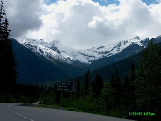
ABOVE: Pemberton Glacier as seen from Pemberton Pass
Gaining elevation into the Pass we noticed the warmer coastal air was being replaced by a cool breeze being swept down the mountains from the glaciers on the surrounding mountains. We stopped at a local Mecca for hikers, a destination called Joffre Peaks. Here you could do easy day hikes, hard day hikes to the upper two lakes in the shadow of the MattierGlacier, or if you were crazy enough you could climb on the glacier itself.
ABOVE: First Lake at Joffre Peaks
Us, we just went 10 minutes down the trail to First Lake,a green gem of a lake in the shadow of Joffre Peak. Even that was rewarding enough, and it required several photos to capture before the mosquitoes chased us back to the cars.
A few more minutes of climbing brought us to the full height of the pass, and the next 20 miles consisted of level travel, with a slight downward trend as we headed for Lillooet. As we went along the vistas had us continually chattering on the CB asking each other if we seen "that mountain", or "this peak", or "the lake back there".
Duffey Lake is the halfway point on the pemberton Pass,and it is a deep glacier carved narrow lake between two mountain peaks, and COLD !! BRRRRRRRR !!
ABOVE: Duffey Lake
Here we pulled out the sweatshirts and hats while we drank in the cool mountain scenery; avalanche chutes stretching from the mountain peaks 3000 feet above us running all the way down the mountain into the lake, reminded us of how truly wild this area was.
Quite often during winter this route is closed due to bad weather, snow accumulations and the danger of avalanches.
ABOVE: Cayoosh Creek (cayoosh is a derivative of the Native word "cayuse", meaning pony)
We continued on along the road still awed by the scenery presented around every new bend of the road. We reached the end of the lake, and drove alongside Cayoosh Creek as it ran angrily beside the road, almost at road level in spots.
Soon enough we started our steep descent from the high mountain pass, down through the sharp switchbacks where 20 miles an hour was too fast for the corner, and if you looked straight down you could see the highway a thousand feet below you.
Before we knew it we were spit out of the narrow valley pass where vertical walls 2000 feet tall were so close you swear you could throw a rock from one side and make it skip across to the other.
Suddenly we were down, no more second gear needed to hold us back.....we had reached the other side and the Fraser River was once again in site. We were now 2/3 of the way through our trip, and a stretch break at Seton Lake presented us with a contradiction of sorts.
We had started off in the cool, rain showered West Coast, right on the ocean with it's rain forest of Western Red Cedars, Douglas Firs and soaring waterfalls; then we climbed through a high mountain pass with peaks covered in year round glaciers that blew a cold wind on us, and now we were back in summer-like weather!!
The hot wind felt like a warm August breeze as it blew along the light green waters of the lake, and we were wondering how half an hour ago we could have felt so so cold even wearing a sweat shirts.
We shed our excess garments and rolled down the windows to let the summer in.The tall rain coast trees had been replaced by Ponderosa and Lodgepole Pines, interspersed with various Birch and Spruce species. The water loving wild ferns of the West Coast forest floor were replaced with bunch grass more conducive to rattlesnake territory.
We were in the rainshadow of the mountains, and the arid landscape was indicative of the low amount of precipitation that made it over themountains. All that water that we had as rain in Squamish was now destined for the glaciers in Pemberton Pass.
Lillooet is the Mile Zero on the Caribou Wagon Road of the Gold Rush Days.70 Mile House, 100 Mile House, 150 Mile House, all exist today due to their beginnings as stage coach stops during the 1890's; their names are indicative of their distance from Lillooet Mile Zero.
ABOVE: Mile Zero of the Caribou Wagon Road
We had a quick tour of the highlights of the town; the Mile Zero cairn, the Hanging Tree where Judge Begbie dispensed frontier justice to 8 men, similar to the legend of Judge Roy Bean; the remnants of gold diggings by the Chinese workers from the railroads; mountains of grave land bedrock all lined up in an orderly fashion; and the museum with it's placer gold mining equipment.
"The Bridge of the 23 Camels"; this is a new bridge named to commemorate the bright soul that thought camels would make an excellent pack animal in the arid land of the Thompson Plateau. Only problem was the soft feet of the camels was ripped apart by the hard rock of the trails.
By now a time check showed it to be 6.00 PM, and we still had many miles to go. We pushed on through the dry country as we now followed the Fraser River high above it on the bench lands formed thousands of years ago from a time when the Fraser was many times it's present size.
The landscape was more desolate then we were used to; sparse Ponderosa Pines with their reddish trunks sparingly covered the hillsides, prime habitat for deer, and we saw one right at the edge of the road feeding 4 feet of the highway. It was so well camouflaged that we did not see it until we were only 20 feet away!
The appearance of more farms and houses indicated that we were approaching Lytton. Here we wanted to see the contrasting colours of two rivers merging. The Thompson River flows a deep blue as it travels through the harder bedrock of it's watershed; cleaner gravel and less sediment means less contamination and a"purer" water column.
By contrast the Fraser's watershed is composed of more sandy and clay like hills and mountains, small particles easily suspended by the mighty river that contribute to it's "muddy" appearance. Where the two mighty rivers meet is a clash of colour and a fight for supremacy. The Thompson resists the embrace of the muddy Fraser for hundreds of feet downriver, but the Fraser eventually wins.
Where the two rivers first meet there is a fine line between blue and mud, just like someone took a pencil and drew a line. But we were denied this treat today..it was now 8.00 PM and the sun was disappearing behind the mountains, and the absence of bright sunlight caused the shadows to hide this exceptional sight. Somewhat disappointed we walked back tothe cars, but in true Backroader fashion we were already planning another day's adventure to this area.
Seeing as that we were about to enter the scenic Fraser Canyon in the twilight, we would be missing all the wonderful sights that this region has to offer. We decided to hold a future trip and take the day to explore the Fraser Canyon at a leisurely pace.
Back on the road we high tailed it south towards Hope and the end of daylight and the end of the tour. We pulled into Hope just as dark was falling, at 9.00 PM and had a late meal at one of the local restaurants that served meals that were too big, and HUGE portions of home cooked pies.
We fed our tummies with food and our brains with coffee, then feeling rejuvenated, we headed back out on the road for our last leg of the trip towards home.
It was an awfully long day that passed way too quickly, and the sights that we had seen continually amazed us, and I think I got a sore neck from whipping it around trying to see everything there was to see. It was an ambitious day, not for the faint of heart, and we made the most of it !!
In true Backroads mentality, knowing we missed a lot, and knowing there is so much more to see, that another Fraser Canyon trip won't wait too long before we are once again racing alongside the Fraser River rubbernecking at the Super Natural Scenery of BC
Went to a caching event tonight hosted by Catapult Jeff and met the usual great group of cachers from around the Lower Mainland.
The event was listed as a chance to bring those travel bugs in need of some TLC to the "hospitable" to get fixed up, cleaned up, and back on the road to complete their mission in life. MrTJ and I, tjguy98 (or as were known as, "The TJ Brothers"), attended the event and enjoyed the evening in the company of cachers we have known for a while. Plus we had the opportunity to meet some new cachers that we had not yet met up with on the trail.
The event was held at the ABC Restaurant in Surrey, and we had our own room for the group, which was nice way to do it.
I decided that I would call this a day of "car caching" in Langley as most of the caches we did seemed to be car related. We found numerous caches in a series named after the cartoon movie "Cars". Even our first cache was called Gomer Pyle and it was located at a private garage where the owner was obviously a nostalgia buff as he had made the garage look like a service station from the 1950's.
The owner has installed two old gas pumps, placed old pop signs and an old temperature gauge near the office door, and had even placed an old roadster racing car from what I would guess is from the 1940s or older on the roof of the garage.
Mixed in among the car caches were a cache at a Starbucks, (always fun to try and be inconspicous there), a cache by the Nicomekl River, another cache in a flood zone along the Nicomekl River, (could not find that one), a skate board park cache, several neighbourhood park caches, and a cache in a green belt area that we have visted a few times before.
Along the way we ran into some fellow cachers and surprised them with the camcorder running. We got the basic reaction of "WHADAYA DOING WITH THAT CAMERA, WHADDAYFILMING US FOR"? Once we explained who we were, Mr and Mrs Bigbopper1 were put at ease, and we had a pleasant conversation with them about caching and other things in life.
ABOVE: The Albion Ferry
We capped the day off by taking a night time cruise across the Fraser River on the Albion Ferry on our way home to Maple Ridge.
I shot video continously during the day and have put togther the more interesting tidbits for you to view.
You can click on the video below to watch it here; you can also scroll down to the bottom of the page to see my other recent YouTube videos. Look for me on YouTube by searching for tjguy98
 I've been caching for 5 years now, (doesn't seem that long ago that I found my first cache), and the thrill of the search isn't as strong as it once was.


