 ABOVE: Brittania Beach area circa 1974
It was interesting to see the old pictures of the mine from 40, 60 and 100 years ago.
Back on the highway and another ten minutes found us at Shannon Falls, a must see for anyone driving this route. Shannon Falls slides through a narrow gap at the top of a 1200 foot cliff, and crashes noisily down a sheer cliff wall, creating a wall of mists that spreads for hundreds of feet away from the cliff site. Even Shannon Creek that leads the water away from the falls is wide, rough and full of sass as it demands your attention.
 ABOVE: Shannon Falls just south of Squamish BC
It caroms down a steep hill side and over the house size boulders that, over time, weathering actions caused them to come loose from the cliff face. I have fond memories of Shannon Falls; as children our parents would come here for a day of picnicking and playing, and my brothers and I would climb right to the base of the falls and try to stand in the torrent of water without getting knocked over. On a hot August day the cool mountain water fresh from the glaciers above was heaven!
Five minutes up the road was the logging town of Squamish, and it looks like every other logging town in the Pacific Northwest. The chosen ride is a pickup truck with a toolbox or huge diesel tank in the bed, all part of the tools of a logger.
Squamish is being rejuvenated by eco-tourists anxious to see some of the remaining pure forests close to Vancouver, as well as those that are brought up from Vancouver by the Royal Hudson, a restored steam train that makes daytrips to Squamish. Plus, all the tourists on their way to Whistler and Blackcomb ski resorts stop in for a coffee, donut and a chance to re-stock their supplies.
A trip to the area wouldn't be complete without a side trip to Brackendale, home to the world's largest winter congregation of Bald Eagles. While we were not in prime viewing time, there were still some juvenile Bald Eagles circling and playing on the thermal currents generated by the warm sun. And in the waters of the Squamish River a harbour seal dived repeatedly for young salmon and trout in the cloudy waters.
All around us the magnificence of the mountain scenery was hidden by the occasional rain shower that seemed to be following us so far this day. A major bummer to miss out on the towering mountains that encircle this small town.
Next stop was the main tourist Mecca of Whistler and it's multitude of ski slopes, shops, restaurants and clubs that make it so popular to the hordes of people. Even in the height of summer the town was buzzing; I swear that there was a million dollars worth of mountain bikes buzzing around the town. Every place you looked there were families, young folks, and professional riders all pedaling away.
Miles out of town we continued to see athletes in training just a-charging up some of the steep hills that the road had to traverse. We left this bustling, scenic resort and traveled another half hour north on Hwy #99 to the tiny town of Pemberton.
This is a REAL, no frills logging town...two blocks of Main Street, the local hotel with the bar in it, and the ever present railway station. A smattering of houses completed the downtown area, everyone else lived in the outskirts where they could park there heavy machinery and logging trucks on their own property.
Now it was time to turn eastward, still on Hwy #99, and travel through the First Nations area of Mt. Currie. This is BC's biggest Indian reserve, and they hold a rodeo every year that is one of the best examples of real life cowboys, no rhinestones here!
Mt. Currie is situated in the small valley surrounded by the Lillooet River on one side, and the Birkenhead River on the other. The large strip of river delta that is formed by the two rivers is very flat and peaceful; I always expect to see orchard of apple trees on either side of the road.
Mt. Currie was also the start of the steady climb into Pemberton Pass that would take us over the divide of the Coast Mountains as we headed forthe dry Interior of BC. The descent coming back down into Mt. Currie is so steep that cars going by us invariably smelt of burning brakes. I shudder to think how motorhomes make it down the hill without some scary moments.
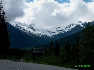 ABOVE: Pemberton Glacier as seen from Pemberton Pass
Gaining elevation into the Pass we noticed the warmer coastal air was being replaced by a cool breeze being swept down the mountains from the glaciers on the surrounding mountains. We stopped at a local Mecca for hikers, a destination called Joffre Peaks. Here you could do easy day hikes, hard day hikes to the upper two lakes in the shadow of the MattierGlacier, or if you were crazy enough you could climb on the glacier itself.
 ABOVE: First Lake at Joffre Peaks
Us, we just went 10 minutes down the trail to First Lake,a green gem of a lake in the shadow of Joffre Peak. Even that was rewarding enough, and it required several photos to capture before the mosquitoes chased us back to the cars.
A few more minutes of climbing brought us to the full height of the pass, and the next 20 miles consisted of level travel, with a slight downward trend as we headed for Lillooet. As we went along the vistas had us continually chattering on the CB asking each other if we seen "that mountain", or "this peak", or "the lake back there".
Duffey Lake is the halfway point on the pemberton Pass,and it is a deep glacier carved narrow lake between two mountain peaks, and COLD !! BRRRRRRRR !!
 ABOVE: Duffey Lake
Here we pulled out the sweatshirts and hats while we drank in the cool mountain scenery; avalanche chutes stretching from the mountain peaks 3000 feet above us running all the way down the mountain into the lake, reminded us of how truly wild this area was.
Quite often during winter this route is closed due to bad weather, snow accumulations and the danger of avalanches.
 ABOVE: Cayoosh Creek (cayoosh is a derivative of the Native word "cayuse", meaning pony)
We continued on along the road still awed by the scenery presented around every new bend of the road. We reached the end of the lake, and drove alongside Cayoosh Creek as it ran angrily beside the road, almost at road level in spots.
Soon enough we started our steep descent from the high mountain pass, down through the sharp switchbacks where 20 miles an hour was too fast for the corner, and if you looked straight down you could see the highway a thousand feet below you.
Before we knew it we were spit out of the narrow valley pass where vertical walls 2000 feet tall were so close you swear you could throw a rock from one side and make it skip across to the other.
Suddenly we were down, no more second gear needed to hold us back.....we had reached the other side and the Fraser River was once again in site. We were now 2/3 of the way through our trip, and a stretch break at Seton Lake presented us with a contradiction of sorts.
We had started off in the cool, rain showered West Coast, right on the ocean with it's rain forest of Western Red Cedars, Douglas Firs and soaring waterfalls; then we climbed through a high mountain pass with peaks covered in year round glaciers that blew a cold wind on us, and now we were back in summer-like weather!!
The hot wind felt like a warm August breeze as it blew along the light green waters of the lake, and we were wondering how half an hour ago we could have felt so so cold even wearing a sweat shirts.
We shed our excess garments and rolled down the windows to let the summer in.The tall rain coast trees had been replaced by Ponderosa and Lodgepole Pines, interspersed with various Birch and Spruce species. The water loving wild ferns of the West Coast forest floor were replaced with bunch grass more conducive to rattlesnake territory.
We were in the rainshadow of the mountains, and the arid landscape was indicative of the low amount of precipitation that made it over themountains. All that water that we had as rain in Squamish was now destined for the glaciers in Pemberton Pass.
Lillooet is the Mile Zero on the Caribou Wagon Road of the Gold Rush Days.70 Mile House, 100 Mile House, 150 Mile House, all exist today due to their beginnings as stage coach stops during the 1890's; their names are indicative of their distance from Lillooet Mile Zero.
 ABOVE: Mile Zero of the Caribou Wagon Road
We had a quick tour of the highlights of the town; the Mile Zero cairn, the Hanging Tree where Judge Begbie dispensed frontier justice to 8 men, similar to the legend of Judge Roy Bean; the remnants of gold diggings by the Chinese workers from the railroads; mountains of grave land bedrock all lined up in an orderly fashion; and the museum with it's placer gold mining equipment.
"The Bridge of the 23 Camels"; this is a new bridge named to commemorate the bright soul that thought camels would make an excellent pack animal in the arid land of the Thompson Plateau. Only problem was the soft feet of the camels was ripped apart by the hard rock of the trails.
By now a time check showed it to be 6.00 PM, and we still had many miles to go. We pushed on through the dry country as we now followed the Fraser River high above it on the bench lands formed thousands of years ago from a time when the Fraser was many times it's present size.
The landscape was more desolate then we were used to; sparse Ponderosa Pines with their reddish trunks sparingly covered the hillsides, prime habitat for deer, and we saw one right at the edge of the road feeding 4 feet of the highway. It was so well camouflaged that we did not see it until we were only 20 feet away!
The appearance of more farms and houses indicated that we were approaching Lytton. Here we wanted to see the contrasting colours of two rivers merging. The Thompson River flows a deep blue as it travels through the harder bedrock of it's watershed; cleaner gravel and less sediment means less contamination and a"purer" water column.
By contrast the Fraser's watershed is composed of more sandy and clay like hills and mountains, small particles easily suspended by the mighty river that contribute to it's "muddy" appearance. Where the two mighty rivers meet is a clash of colour and a fight for supremacy. The Thompson resists the embrace of the muddy Fraser for hundreds of feet downriver, but the Fraser eventually wins.
Where the two rivers first meet there is a fine line between blue and mud, just like someone took a pencil and drew a line. But we were denied this treat today..it was now 8.00 PM and the sun was disappearing behind the mountains, and the absence of bright sunlight caused the shadows to hide this exceptional sight. Somewhat disappointed we walked back tothe cars, but in true Backroader fashion we were already planning another day's adventure to this area.
Seeing as that we were about to enter the scenic Fraser Canyon in the twilight, we would be missing all the wonderful sights that this region has to offer. We decided to hold a future trip and take the day to explore the Fraser Canyon at a leisurely pace.
Back on the road we high tailed it south towards Hope and the end of daylight and the end of the tour. We pulled into Hope just as dark was falling, at 9.00 PM and had a late meal at one of the local restaurants that served meals that were too big, and HUGE portions of home cooked pies.
We fed our tummies with food and our brains with coffee, then feeling rejuvenated, we headed back out on the road for our last leg of the trip towards home.
It was an awfully long day that passed way too quickly, and the sights that we had seen continually amazed us, and I think I got a sore neck from whipping it around trying to see everything there was to see. It was an ambitious day, not for the faint of heart, and we made the most of it !!
In true Backroads mentality, knowing we missed a lot, and knowing there is so much more to see, that another Fraser Canyon trip won't wait too long before we are once again racing alongside the Fraser River rubbernecking at the Super Natural Scenery of BC


